Skip to content

Un Volcan à Rognes ! EarthCache

Hidden : 6/18/2019
Difficulty:
2 out of 5
Terrain:
2 out of 5

Size: Size:   other (other)

Join now to view geocache location details. It's free!

Watch

How Geocaching Works

Please note Use of geocaching.com services is subject to the terms and conditions in our disclaimer.

Geocache Description:


DESCRIPTIF EN FRANCAIS (FR) : (SEE ENGLISH DESCRIPTION (EN) BELOW)

Cette earthcache va vous faire découvrir une singularité géologique : les restes d’un volcan sur la commune de Rognes !

UN VOLCAN EXPLOSIF :

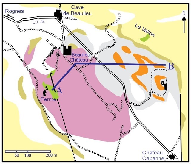
Le pointement basaltique de Beaulieu se situe à 2 km environ au SE du village de Rognes, et à 13 km au NW d'Aix-en-Provence. Il est peu visible dans le panorama des collines de la Trévaresse, aucun cône n’est visible, en raison de son relief peu accusé et des nombreuses cultures (= vignobles et céréales) qui se sont installées sur la lave altérée.

Il faut traverser le domaine de Beaulieu en empruntant la RD14c entre Rognes et Puyricard pour prendre conscience de son existence. La superficie occupée par les laves n'excède pas 5 km2. Néanmoins, c'est un des centres volcaniques les plus importants de la Provence occidentale. De toute part, les terrains sédimentaires d'âge tertiaire l'entourent.

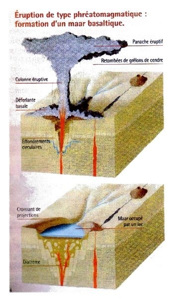
Il s'agit en fait d'un volcan "en creux", effondré, dont l'ancien cratère de forme ovale s'est rempli de lave suite à son éruption explosive de type phréatomagmatique (= causée par le contact de la lave avec un milieu aqueux). Ainsi, l'éruption de ce volcan a eu lieu au coeur d'un ancien lac.

Ces éruptions génèrent un fort dégazage, et des colonnes de cendres composées d'un mélange de vapeur d'eau, de particules et de fragments solides (= cendres, bombes...). Mais aussi des nuées déferlantes basales, horizontales, éjectant des blocs de tailles diverses, souvent anguleux, formés de basalte ou de calcaire provenant des terrains superficiels traversés. 

Le pourtour du volcan finit par s'effondrer et créer un cratère qui se remplira de lave : on appelle cela un Maar. On ne connait pas exactement la profondeur du lac de lave ainsi formé. 7 sondages effectués en 1968 se sont arrêtés à 80 m, ce qui est son épaisseur minimale, mais les volcanologues n'écartent pas une profondeur de 200 m.

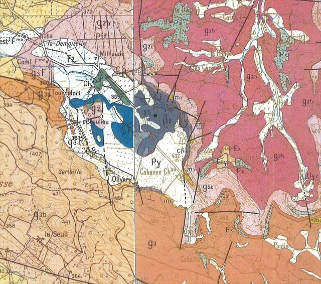
L'analyse de la roche traversée par sondage montre 2 types de basalte : un basalte lourd en profondeur et un basalte léger en surface, représentant la crème du lac de lave.

Le basalte léger est principalement représenté dans la partie N-NE où il a été exploité pour du ballast dans une ancienne petite carrière. L'autre basalte serait lié à une cheminée latérale et la coulée se serait effectuée en partie sous l'eau créant des laves en coussinets. 

Les affleurements intéressants existent grâce à d'anciennes exploitations situées dans le domaine privé viticole de Beaulieu. Ces affleurements permettent d'observer une prismation grossière alors que d'autres montrent une altération en boules.

Tout autour des restes du volcan, on retrouve des dépôts issus de cette explosion, constitués d'un mélange de blocs de tailles diverses, souvent anguleux, formés de basalte ou de roches provenant de la cheminée qui s'est ouverte dans les terrains superficiels calcaires.

Une datation radiométrique à 18,2 +/- 0,5 Ma par la méthode K/Ar (= potassium / argon) sur roche totale permet d'attribuer un âge burdigalien (= Miocène) à ce volcanisme. Cette méthode est idéale pour dater des roches volcaniques.

Le basalte de Beaulieu est un basalte alcalin finement cristallisé renfermant de gros cristaux d'olivine (= péridot, minéral souvent vert) et de pyroxène (= minéral ferromagnésien) dans une gangue composée de petits cristaux de feldspath (= silico-aluminate) et d'olivine. On y trouve parfois des enclaves de péridotite (= roche magmatique ferromagnésienne riche en olivine).

Dans les environs, au droit des formations sédimentaires, de nombreux fossiles ont été retrouvés, notamment des os de mammifères divers et variés, des dents de requins, des carapaces de tortues, et de gros os d'Anthracotherium (= apparenté aux porcs et hippopotames).

LE CONTEXTE GEOLOGIQUE :

L’existence de ce volcan est reconnue depuis la fin du 18è siècle par H. de Saussure (= le premier homme à faire l'ascension du Mont-Blanc), qui y remarqua également la présence de fossiles d'animaux terrestres dans les environs. Mais l'intérêt pour ce volcan ne se manifesta que dans les années 1960.

Au Miocène, le domaine de Beaulieu et ses environs faisaient partie du littoral de la Méditerranée occidentale de l’époque. C’est pourquoi on retrouve, dans la région, des dépôts marins de zone peu profonde, des dépôts lagunaires, et des dépôts palustres (= qui se rapportent aux marais).

Il y a 18 Ma, la mer recouvre Rognes envahissant profondément l'actuelle vallée de la Durance. La mer chaude, peu profonde, abrite une riche faune tropicale : requins, dauphins, baleines, coquillages... Au fond de l'eau se dépose un sable argileux, cimenté par une vase calcaire jaune englobant les restes de cette riche faune marine, c'est le Miocène de Provence. Avec le temps, cette boue durcie donne une roche coquillère jaune facile à travailler : la pierre de Rognes, exploitée en carrières pour la construction, ou comme pierre d'ornementation. Alors que cette mer s'étend à perte de vue, le complexe volcanique de Rognes se met en place à proximité du rivage.

Au début du Miocène, la partie centrale de l'actuel bassin d'Aix a été le siège d'un volcanisme alcalin (= riche en sodium et potassium), qui pourrait être le témoin d'un phénomène distensif enregistré par les formations sédimentaires continentales.

Ce contexte distensif est à l’origine de l’ouverture d'un petit bassin océanique provençal sur une ligne de dislocation profonde, orientée NW-SE, qui a rejoué au Tertiaire. L'éloignement des plaques tectoniques, suivi de la rotation du bloc corso-sarde, a eu pour conséquence l’amincissement de la croûte terrestre et sa fracturation, facilitant la remontée de magma en surface, qui pourrait être notamment à l'origine du basalte du volcan de Beaulieu.

LE VIGNOBLE :

Les 180 ha de vignoble du domaine de Beaulieu, un des plus vastes des Coteaux d'Aix, s'épanouissent depuis plus de 2000 ans, nichés dans l'ancien cratère du volcan éteint de la Trévaresse, à 400 m d’altitude.

Le site, face au Lubéron, qui domine la vallée de la Durance, l’Abbaye de Silvacane et la Roque d’Anthéron, offre un terroir très diversifié.

Outre des terroirs argilo-calcaires, une grande partie du vignoble est plantée en terroir volcanique caractérisé par la présence de basalte, ce qui fonde le développement d'une réelle typicité de ses vins.

Propriété historique des comtes de Provence, érigé en fief par Henri III en 1576, les plus grandes familles provençales s'y succédèrent. Les Alamanon, Agoult, Oraison, Pontleroy, mais aussi les Tournefort et les Candolle y résidèrent attentifs à préserver ce terroir exceptionnel.

UN VOLCANISME MAL AIMÉ :

Ce volcanisme provençal est un "mal aimé" du volcanisme français. On trouve également 3 ou 4 autres petits affleurements de même type en PACA (Beaulieu ; Evenos près de Toulon ; Cogolin près de Saint-Tropez...). Il s'agit d'un volcanisme basaltique, de la série alcaline et d'âge miocène (-14/20 Ma).

Il est en de nombreux points comparable au volcanisme du Massif Central (qui lui a duré plus longtemps que cela), ou d'Alsace. Le problème du volcanisme alcalin mio-plio-quaternaire d'Europe de l'Ouest reste débattu et controversé. Il y a plusieurs écoles et toutes ces hypothèses ne sont d'ailleurs pas contradictoires. Malgré leur ressemblance, toutes ces provinces ne sont peut-être pas reliées aux mêmes causes.

Le moins que l'on puisse dire, c'est que le lien entre ce volcanisme (Miocène, -14/20 Ma) et l'ouverture de la Méditerranée (Oligocène supérieur, -25 Ma) n'est pas manifeste ni clair. Tout au plus on pourra montrer que ce volcanisme de Rognes repose sur de l'Oligocène ; mais celui d'Evenos repose sur du Mésozoique, et celui de Cogolin sur du socle.

On pourra aussi montrer que l'Oligocène est une période où se forme un bassin en extension (Aix, Carpentras et la Méditerranée occidentale), mais ce volcanisme a lieu 5 à 10 Ma après le fonctionnement de cette extension. Montrer le volcanisme de Beaulieu est donc sans doute un bel exercice : on pourra faire de la chronologie relative (il est post-oligocène puisqu'il le recoupe et le recouvre), et montrer laves et péridotites... Mais on ne pourra pas démontrer de façon formelle qu'il est lié à une extension.

SOURCES :

http://www.chateaubeaulieu.fr/lunique-volcan-de-provence/4
http://www.lithotheque.ac-aix-marseille.fr/Affleurements_PACA/13_bassin_aix/13_bassin_aix_central_beaulieu.htm
https://planet-terre.ens-lyon.fr/article/volcanisme-provencal.xml

RECOMMANDATIONS POUR UNE GESTION RAISONNÉE DU PATRIMOINE NATUREL :

Conserver ces lieux intacts, en évitant les mouvements de terrain, les prélèvements de matériaux, les remblais et les déblais. Ne pas faire de publicité particulière autour de la présence de ce site, ce qui suffit souvent à éviter tout acte de vandalisme mercantile.

POUR VALIDER CETTE EARTHCACHE (FR) :

Rendez-vous tout d'abord au PK1 ; Vous effectuerez la balade à pieds, en boucle ;
Rallier le WP1 en direction du NW, en suivant la route mais en marchant le long des vignes pour des raisons de sécurité : Q1 et Q2 ;

Continuez le long des vignes jusqu'au WP2 qui correspond au début du chemin qui vous mènera vers le NE au WP3 : Q3 ;
Suivez ensuite les WP4 à 8, et répondez à chaque fois à la question posée : Q4 à Q7 ;
Depuis le WP8, pour rejoindre le véhicule au PK1, traversez les vignes vers le SW en direction de la route en contrebas ;

Non loin du PK1, rendez-vous au WP9, pour la photo facultative (Q8).
Bonne promenade et bonne découverte !

Pour se conformer aux directives éducatives des Earthcaches, vous devez répondre aux questions suivantes, qui peuvent nécessiter quelques recherches sur le terrain et dans le descriptif ci-dessus.

Loguez cette Earthcache "Found It" et envoyez-nous vos réponses soit par mail via notre profil, soit par la messagerie géocaching (message center), nous vous contacterons en cas de problème. Tout log sans réponses consécutives sera effacé.

QUESTIONS :

PK1- N43°38.048 E05°23.947
Parking en bord de route.

WP1- VIGNOBLE- N43°38.179 E05°23.880 - PZ de la cache.
Q1 : Avec vos mots, décrivez le terroir (le sol du vignoble) et la roche basaltique le constituant.

Q2 : Observer le paysage autour de vous, décrivez-le. Quelle est sa particularité volcanologique d'après les explications données dans le descriptif ? Où vous situez-vous dans un tel contexte ?

WP2- N43°38.345 E05°23.677
Début du chemin vers le WP3.

WP3- PANNEAU VOLCAN- N43°38.385 E05°23.834
Q3 : Qu'y a t-il de représenté sous les carrés jaunes de la photo ci-dessous ?

WP4- VOLCAN- N43°38.427 E05°23.882
Q4 : Décrivez la roche et sa couleur. Selon vous, est-elle d'origine volcanique ? Qu'observez-vous de spécifique sur certains blocs permettant d'en attester ?

WP5- VOLCAN- N43°38.357 E05°23.855
Q5 : Quelle est la particularité de la roche volcanique à cet endroit ? A quel processus géologique correspond-elle selon vous ?

WP6- VOLCAN- N43°38.267 E05°23.878
Q6 : Quelle est la particularité de la texture de la roche volcanique à cet endroit ? Tentez d'expliquer à quoi cela est dû.

WP7- N43°38.212 E05°24.014
Passage vers le WP8.

WP8- VOLCAN- N43°38.218 E05°24.021
Q7 : Décrivez le gros bloc de basalte devant vous. D'après-vous à quoi correspond-il ? Quelle est sa taille approximative ?

WP9- VOLCAN- N43°38.037 E05°23.959
Q8- FACULTATIF : Vous pouvez aller prendre une photo de vous ou de votre GPS devant le panneau "Château Beaulieu".

!! MERCI DE NE PAS PRENDRE DE PHOTOS DES DIFFERENTS WAYPOINTS NI DU PANNEAU VOLCAN AU WP3 !!

***********************
***********************

ENGLISH DESCRIPTION (EN) :

This earthcache will make you discover a geological singularity : the remains of a volcano in the municipality of Rognes !

AN EXPLOSIVE VOLCANO :

The basaltic point of Beaulieu is about 2 km southeast of the village of Rognes, and 13 km north of Aix-en-Provence. It's not very visible in the panorama of the hills of Trevaresse, no cone is visible, because of its relief little accused and the many cultures (= vineyards and cereals) which settled on the altered lava.

You have to cross the Beaulieu area by taking the RD14c between Rognes and Puyricard to become aware of its existence. The area occupied by the lavas does not exceed 5 km2. Nevertheless, it is one of the most important volcanic centers of western Provence. On all sides, Tertiary sedimentary grounds surround it.

It is actually a "hollow" volcano, collapsed, the old crater oval-shaped filled with lava following its explosive eruption type phreatomagmatic (= caused by the contact of the lava with a aqueous medium). Thus, the eruption of this volcano took place in the heart of an old lake.

These eruptions generate a strong degassing, and columns of ash composed of a mixture of water vapor, particles and solid fragments (= ashes, bombs ...). But also basal, horizontal breaking clouds, ejecting blocks of various sizes, often angular, formed of basalt or limestone from the superficial terrain crossed.

The edge of the volcano finally collapses and create a crater that will fill with lava : it is called a Maar. The depth of the lava lake thus formed is not known exactly. 7 holes in 1968 stopped at 80 m, which is its minimum thickness, but volcanologists do not deviate a depth of 200 m.

The analysis of the rock traversed by sound shows 2 types of basalt : a heavy basalt deep and a light basalt on the surface, representing the cream of the lava lake.

Light basalt is mainly represented in the N-NE where it was exploited for ballast in a former small quarry. The other basalt would be linked to a lateral chimney and the casting would have been done partly under the water creating lava in pads.

The interesting outcrops exist thanks to old farms located in the private vineyard domain of Beaulieu. These exposures make it possible to observe a rough prismation while others show an alteration in balls.

All around the remains of the volcano, there are deposits from this explosion, consisting of a mixture of blocks of various sizes, often angular, formed of basalt or rocks from the chimney which opened in the superficial limestone grounds .

A radiometric dating at 18.2 +/- 0.5 Ma by the K / Ar method (= potassium / argon) on total rock allows to attribute a Burdigalian age (= Miocene) to this volcanism. This method is ideal for dating volcanic rocks.

Beaulieu basalt is a finely crystallized alkaline basalt containing large crystals of olivine (= peridot, often green mineral) and pyroxene (= ferromagnesian mineral) in a gangue composed of small crystals of feldspar (= silico-aluminate) and olivine. There are sometimes enclaves of peridotite (= ferromagnesian magmatic rock rich in olivine).

In the vicinity, to the right of sedimentary formations, many fossils have been found, including various mammalian bones, shark teeth, turtle shells, and large bones Anthracotherium (= related to pigs and hippos) .

THE GEOLOGICAL CONTEXT :

The existence of this volcano is recognized since the end of the 18th century by H. de Saussure (= the first man to climb Mont Blanc), who also noticed the presence of terrestrial fossils in the area. But the interest for this volcano did not manifest itself until the 1960s.

In the Miocene, the area of ​​Beaulieu and its surroundings were part of the coast of the western Mediterranean at the time. For this reason, there are shallow marine deposits, lagoon deposits, and marsh deposits (= that relate to marshes) in the area.

18 Ma ago, the sea covers Rognes deeply invading the current valley of the Durance. The warm, shallow sea is home to a rich tropical fauna: sharks, dolphins, whales, shells... At the bottom of the water is deposited a clay sand, cemented by a yellow limestone vase including the remains of this rich marine fauna, it's the Miocene of Provence. Over time, this hardened mud gives a yellow rock easy to work : Rognes stone, quarried for construction, or ornamentation stone. While this sea extends as far as the eye can see, the volcanic complex of Rognes is set up near the shore.

At the beginning of the Miocene, the central part of the Aix current basin was the seat of an alkaline volcanism (= rich in sodium and potassium), which could be the witness of a distensive phenomenon recorded by the continental sedimentary formations.

This distensive context is at the origin of the opening of a small Provençal ocean basin on a line of deep dislocation, oriented NW-SE, which replayed in the Tertiary. The remoteness of the tectonic plates, followed by the rotation of the Corsican-Sardinian block, resulted in the thinning of the earth's crust and its fracturing, facilitating the rise of magma on the surface, which could be at the origin of the basalt of the Beaulieu volcano.

THE VINEYARD :

The 180 ha vineyard of the Domaine de Beaulieu, one of the largest Coteaux d'Aix, has flourished for more than 2000 years, nestled in the ancient crater of the extinct volcano of Trévaresse, 400 m above sea level.

The site, facing the Lubéron, which dominates the valley of the Durance, the Abbey of Silvacane and the Roque d'Anthéron, offers a very diversified soil.

In addition to clay-limestone soils, a large part of the vineyard is planted in volcanic soil characterized by the presence of basalt, which is the basis for the development of a real typicity of its wines.

Historic property of the Counts of Provence, built in fief by Henry III in 1576, the largest Provencal families succeeded one another. The Alamanon, Agoult, Oraison, Pontleroy, but also Tournefort and Candolle stayed there attentive to preserve this exceptional soil.

A NOT LIKE VOLCANISM :

This Provençal volcanism is a "badly liked" French volcanism. There are also 3 or 4 other small outcrops of the same type in PACA (Beaulieu, Evenos near Toulon, Cogolin near Saint-Tropez ...). It's a basaltic volcanism, alkaline series and Miocene (-14/20 Ma).

It's in many ways comparable to the Massif Central volcanism (which lasted longer than that), or Alsace. The problem of mio-plio-quaternary alkaline volcanism in Western Europe remains controversial. There are several schools and all these hypotheses are not contradictory. Despite their similarity, all of these provinces may not be related to the same causes.

The least that can be said is that the link between this volcanism (Miocene, -14/20 Ma) and the opening of the Mediterranean (Upper Oligocene, -25 Ma) is not obvious or clear. At most we can show that this volcanism of Rognes rests on Oligocene ; but that of Evenos rests on Mesozoic, and that of Cogolin on pedestal.

It can also be shown that the Oligocene is a period in which a basin is formed in extension (Aix, Carpentras and the Western Mediterranean), but this volcanism takes place 5 to 10 Ma after the operation of this extension. To show the volcanism of Beaulieu is undoubtedly a good exercise : we will be able to make the relative chronology (it is post-Oligocene since it cuts it and covers it), and to show lava and peridotites... But we will not be able to demonstrate formally that it is linked to an extension.

SOURCES :

http://www.chateaubeaulieu.fr/lunique-volcan-de-provence/4
http://www.lithotheque.ac-aix-marseille.fr/Affleurements_PACA/13_bassin_aix/13_bassin_aix_central_beaulieu.htm
https://planet-terre.ens-lyon.fr/article/volcanisme-provencal.xml

RECOMMENDATIONS FOR A RATIONAL MANAGEMENT OF THE NATURAL HERITAGE :

Preserve these intact spot, avoiding the movements of the ground, the taking of materials, the embankments and the cuttings. Do not advertise people around the presence of fossils on the site, which is often enough to avoid any act of mercantile vandalism.

TO VALIDATE THIS EARTHCACHE (EN) :

Go first to PK1 ; You will walk on foot, in a loop ;
Take the WP1 towards the NW, following the road but walking along the vineyards for safety reasons : Q1 and Q2 ;
Continue along the vineyards until WP2 is the beginning of the path that will take you to the NE at WP3 : Q3 ;
Then follow WP4 to 8, and answer each time the question asked : Q4 to Q7 ;
From WP8, to reach the vehicle at PK1, cross the vineyards towards the SW towards the road below ;
Not far from PK1, go to WP9, for optional photo (Q8).
Good walk and good discovery !

To comply with the educational guidelines of Earthcaches, you should answer the following questions, which may require some research directly on the spot or in the geological description above.

Log this Earthcache "
Found It" and send us your answers either by mail on our profile, or by geocaching message center, we will contact you in case of problems. All unanswered log will be deleted.

QUESTIONS :

PK1- N43 ° 38.048 E05 ° 23.947
Parking by the road.

WP1- VINEYARD- N43 ° 38.179 E05 ° 23.880 - PZ of the cover.
Q1 : With your words, describe the terroir (the soil of the vineyard) and the basalt rock that makes it up.
Q2 : Observe the landscape around you, describe it. What is its volcanological peculiarity according to the explanations given in the description ? Where do you stand in such a context ?

WP2- N43 ° 38.345 E05 ° 23.677
Beginning of the path to WP3.

WP3- PANEL VOLCANO- N43 ° 38.385 E05 ° 23.834
Q3 : What is represented under the yellow squares of the photo below ?

WP4- VOLCANO- N43 ° 38.427 E05 ° 23.882
Q4 : Describe the rock and its color. According to you, is it of volcanic origin ? What do you observe specific about some blocks to attest ?

WP5- VOLCANO- N43 ° 38.357 E05 ° 23.855
Q5 : What is the particularity of the volcanic rock at this location ? Which geological process do you think it corresponds to ?

WP6- VOLCANO- N43 ° 38.267 E05 ° 23.878
Q6 : What is the peculiarity of the volcanic rock texture at this location ? Try to explain what is due.

WP7- N43 ° 38.212 E05 ° 24.014
Switch to WP8.

WP8- VOLCANO- N43 ° 38.218 E05 ° 24.021
Q7 : Describe the large block of basalt in front of you. What do you think it is ? What is its approximate size ?

WP9- VOLCANO- N43 ° 38.037 E05 ° 23.959
Q8- OPTIONAL : You can take a picture of yourself or your GPS in front of the "Château Beaulieu" sign.

!! PLEASE DO NOT TAKE PICTURES FROM DIFFERENT WAYPOINTS OR VOLCANO PANEL ON WP3 !!

***********************
***********************

PODIUM :

Additional Hints (No hints available.)