|

No Princípio, Era Selva
A floresta milenar que revestia inteiramente os 386 km² do atual município de Antônio Prado permaneceu intocável, como ilha inacessível, até pelo ano de 1880. Nem os missionários jesuítas, que fundaram a Vacaria dos Pinhais, e o próprio padre Francisco Ximenes, que em 1633 efetuou o levantamento da região, puseram os pés aqui, assim como não fez a bandeira de Raposo Tavares, em 1863.
Os fazendeiros dos Campos da Vacaria, no século XV, penetravam na mata que circunda o campo, ocupando terras para implantar suas lavouras e invernadas. Entretanto, não ultrapassaram a atual linha divisória do município. Só os indígenas, tape e coroado (caingangue), percorriam as montanhosas paragens, cobertas de imensos pinhais, de cujo fruto se alimentavam.
O Pioneiro Simão David de Oliveira
Simão David de Oliveira foi o primeiro cidadão que, por volta de 1880, se estabeleceu na margem direita do rio das Antas. Viera a pé de São Paulo, penetrando no território gaúcho por Vacaria. A seguir, contornando o rio Vieira, desceu até ao rio das Antas, de onde prosseguiu caminho até encontrar um lugar aprazível para construir seu rancho. Era o único trecho de terras planas, junto à foz do rio Leão e do arroio Tigre, por onde depois, em princípio de 1886, foi aberta a primeira picada que dava acesso à nova colônia italiana chamada Antônio Prado. Essa picada conhecida como Passo do Simão teve seu nome escolhido em homenagem a Simão David de Oliveira.
Fundação e Implantação da Colônia
Antônio Prado foi a sexta e última das chamadas "antigas colônias da imigração italiana", e foi fundada em maio de 1886. A partir daí, criada a nova colônia, começaram a ser destinadas verbas públicas para abertura de estradas, construção de balsas, medição de terras, construção de barracões, transporte e acolhimento dos colonos. Apesar dos importantes acontecimentos políticos pelos quais o país passava, como a proclamação da República e a Revolução Federalista, em 1893, não houve interferência no processo de implantação de imigrantes em terras devolutas e cobertas de matas da Serra do Rio das Antas.
A revolução de 1893, agitando violentamente quase todos os recantos do estado, pouco podia interferir numa colônia recém-fundada, alcandorada entre paredões, sem estradas, animais de transporte e sem outros recursos econômicos, humanos e financeiros. Deixando de lado as agitações políticas que abalavam o país, a inspetoria e as comissões de medição de lotes e as de terras e colonização, prosseguiram seu patriótico trabalho de estabelecer mais de mil famílias no território do atual município de Antônio Prado.
O porquê do nome "Antônio Prado"
Ficou estabelecido em 1885, pelo imperador do Brasil e por outras autoridades, que, durante o período de 1886/87, seria criado um núcleo de colonização na margem direita do rio das Antas. Este núcleo não tinha nome, por isso, o bacharel Manoel Barata Góis, engenheiro-chefe da Comissão de Medição de Lotes, sugeriu e solicitou que fosse dado à nova colônia o nome de Antônio Prado, em homenagem a Antônio da Silva Prado, fazendeiro paulista que, como ministro da agricultura da época, promoveu a vinda dos imigrantes italianos para o Brasil, e instalou núcleos coloniais no Rio Grande do Sul.
Possui uma área de 343,28 km² e sua população estimada em 2004 era de 13 908 habitantes. Tem densidade demográfica de 37 hab/km² e está situada a uma altitude de 658 metros.
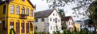
A cidade possui o maior e o mais completo conjunto arquitetônico da colonização italiana no Brasil, com 48 imóveis do centro urbano tombados pelo Instituto do Patrimônio Histórico e Artístico Nacional, desde a década de 1980. Outros imóveis na zona rural de Antônio Prado igualmente sobreviveram ao tempo e se revestem de grande valor histórico e arquitetônico, como marcos da colonização italiana no sul do Brasil.
|
|

In the Beginning, It Was Jungle
The ancient forest that covered the entire 386 km² of the current municipality of Antônio Prado remained untouched, as an inaccessible island, until the year 1880. Neither the Jesuit missionaries, who founded Vacaria dos Pinhais, and Father Francisco Ximenes himself, who in 1633 made the survey of the region, put their feet here, just as did not make the flag of Raposo Tavares in 1863.
The farmers of the Campos da Vacaria, in the fifteenth century, penetrated the forest that surrounds the countryside, occupying lands to implant their crops and wintering. However, they did not exceed the current dividing line of the municipality. Only the natives, tape and crowned (caingangue), traveled the mountainous stops, covered of immense pine-trees, of whose fruit they fed.
The Pioneer Simão David de Oliveira
Simão David de Oliveira was the first citizen who, around 1880, settled down in the right margin of the river of the Antas. He had come on foot from Sao Paulo, penetrating the Gaucho territory by Vacaria. Then, rounding the river Vieira, he descended to the river of the Antas, from where he continued his journey until he found a pleasant place to build his ranch. It was the only stretch of flat land, near the mouth of the Leão River and the Tigre stream, where, in early 1886, the first trail that opened to the new Italian colony called Antônio Prado was opened. This trail known as Passo do Simão had its name chosen in honor of Simão David de Oliveira.
Foundation and Implantation of the Colony
Antônio Prado was the sixth and last of the so-called "former colonies of Italian immigration," and was founded in May 1886. From then on, the new colony was established, public funds for the opening of roads, construction of ferries, of land, construction of sheds, transportation and reception of settlers. In spite of the important political events through which the country passed, such as the proclamation of the Republic and the Federalist Revolution, in 1893, there was no interference in the process of implanting immigrants in vacant lands covered with forests of the Serra do Rio das Antas.
The revolution of 1893, violently shaking almost every corner of the state, could barely interfere with a newly founded colony, nestled between walls, without roads, transport animals, and without other economic, human, and financial resources. Leaving aside the political upheavals that were shaking the country, the province and the commissions of measurement of lots and land and colonization, they continued their patriotic work of establishing more than a thousand families in the territory of the current municipality of Antônio Prado.
The reason for the name "Antônio Prado"
It was established in 1885 by the emperor of Brazil and other authorities that during the period 1886/87 a colonization nucleus would be created on the right bank of the Antas river. This nucleus had no name, so bachelor Manoel Barata Góis, chief engineer of the Lumber Measurement Commission, suggested and requested that the new colony be named Antônio Prado, in honor of Antônio da Silva Prado, a farmer from São Paulo who, as minister of agriculture of the time, promoted the arrival of Italian immigrants to Brazil, and installed colonial nuclei in Rio Grande do Sul.
It has an area of 343.28 km² and its estimated population in 2004 was 13 908 inhabitants. It has a population density of 37 hab / km² and is located at an altitude of 658 meters.
The city has the largest and most complete architectural set of Italian colonization in Brazil, with 48 properties in the urban center registered by the National Historical and Artistic Heritage Institute since the 1980s. Other properties in the rural area of Antônio Prado also survived the time and are of great historical and architectural value, as landmarks of Italian colonization in southern Brazil.
|