Cyklomost slobody
Cyklomost slobody je mostom vedúcim ponad rieku Morava, ktorý prepája slovenský a rakúsky breh, teda územia, ktoré boli donedávna rozdelené politickou bariérou. Je postavený na mieste historického mosta z roku 1771 vystavaného na príkaz Márie Terézie. Pôvodný historický most bol viackrát opravovaný. V roku 1809 ho strhli plávajúce kryhy, v roku 1866 bol vyhodený do vzduchu počas rakúsko-pruskej vojny. Naposledy bol zničený koncom druhej svetovej vojny a k jeho definitívnej skaze prispel nový pohraničný režim spojený so Železnou oponou.
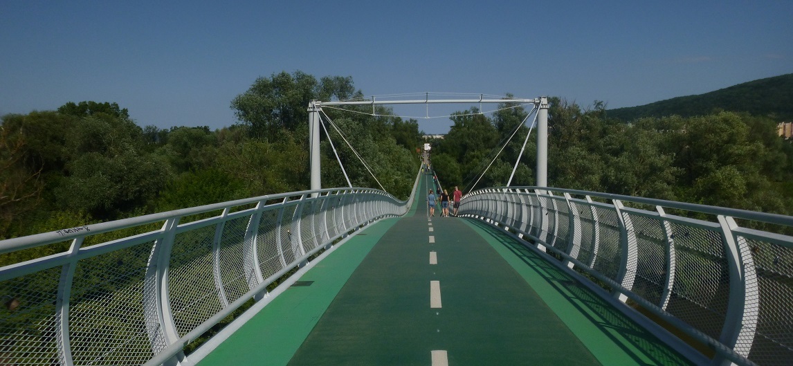
Nová kapitola sa začala písať až programom cezhraničnej spolupráce Slovenska s Rakúskom v rokoch 2007-2013. Základný kameň stavby bol položený 25. septembra 2011. Jeho stavbu komplikovala neustále sa meniaca hladina rieky. Takisto sa musel urobiť aj podrobný archeologický prieskum, lebo pri stavbe boli nájdené pozostatky pôvodného mostného násypu, pochádzajúce z čias vlády Márie Terézie a tiež pilóty pôvodného mosta. Pri výstavbe súčasného mosta sa tieto pôvodné časti nezničili; most bol postavený tak, že vedie ponad tieto historické časti. Jeho celková dĺžka je 955 metrov, z ktorej mostná oceľová konštrukcia má 525 metrov. Most je široký 4 metre a je určený pre peších a cyklistov. Slávnostne bol otvorený 22.septembra 2012.
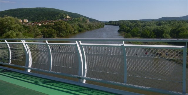
V súčasnosti je most dôležitým spojovacím článkom siete rakúskych a slovenských cyklotrás. Z jeho najvyššej časti sú pekné výhľady na okolie Moravy a smerom na Devínsku Kobylu. Priamo pod mostom sa vlieva do Moravy meandrujúca riečka Mláka. Okrem toho priamo pod mostom nájdete historický bunker z medzivojnového obdobia. V novembri 2013 odhalili pri Cyklomoste slobody pamätnú tabuľu, ktorá pripomína obete Železnej opony - ľudí ktorí tragicky zahynuli pri pokuse o prechod slovensko-rakúskej časti hranice.
Úlohy:
1. Prejdite sa po moste a odhadnite aká dlhá je časť pôvodného mosta z roku 1771 zakomponovaná do novej stavby. A napíšte, či sa nachádza na slovenskej alebo rakúskej strane mosta.
2. Urobte fotku Vás alebo vášho GPS na moste presne na slovensko-rakúskej hranici.
Vašu odpoveď a fotku odosielajte spolu s Vaším Found it! logom. Ak niečo nebude v poriadku, budeme Vás kontaktovať. Logy bez splnených úloh budú vymazané.
Freedom Cycling Bridge
Freedom Cycling Bridge is a bridge over the Morava river, which connects the Slovak and Austrian bank, territories that until recently were divided by a political barrier. It is built on the place of a historic bridge dating back to 1771, built upon the request of Maria Theresa. The original historical bridge was repaired several times. In 1809 it was broken down by icebergs, in 1866 it was blown up during the Austro-Prussian War. The last time it was destroyed by the end of World War II, a new border regime and the Iron Curtain contributed to its final destruction.
The new chapter began with the program of cross-border cooperation between Slovakia and Austria in 2007-2013. The foundation stone of the building was laid on September 25, 2011. Its construction was complicated because of the constantly changing river level. Also, a detailed archaeological survey had to be carried out, since the pillars of the original bridge and the remains of its embankment were found at the construction site, dating back to the reign of Maria Theresa. During the construction of the current bridge, these original parts were not destroyed; the bridge was built over them. Its total length is 955 meters, of which the bridge steel structure is 525 meters long. The bridge is 4 meters wide and it is designed for pedestrians and cyclists. It was inaugurated on 22 September 2012.
At present, the bridge is an important link of the network of Austrian and Slovak cycling routes. From its highest part there are nice views of the surroundings of Moravia and in the direction of Devínska Kobyla. Directly below the bridge there is a meandering river Mláka that flows into Moravia. In addition, there is a historic bunker from the interwar period right under the bridge. In November 2013 a commemorative plaque at the Freedom Cycling Bridge was uncovered, which commemorates the victims of the Iron Curtain – all the people who tragically perished while trying to cross the Slovak-Austrian border.
Tasks:
1. Walk across the bridge and estimate the length of the part of the original bridge from 1771 which is built into the new bridge. Write whether it is on the Slovak or on the Austrian side of the bridge.
2. Take a picture of you or your GPS at the bridge, directly at the Slovak-Austrian borderline.
Send your answer and photo together with your Found it! log. If something is wrong, we will contact you. The logs without the fulfilled tasks will be deleted.
This Virtual Cache is part of a limited release of Virtuals created between June 4, 2019 and June 4, 2020. Only 4,000 cache owners were given the opportunity to hide a Virtual Cache. Learn more about Virtual Rewards 2.0 on the Geocaching Blog.