

🇬🇧 ENGLISH
You are about to take off on a most impressive but challenging hiking tour in beautiful, untouched nature, garnished by many mountain lakes, solitude and perhaps a large ibex colony
The Swiss National Park is one of the best protected areas in the Alps. The visitors are witnesses of the dynamic processes that give this landscape its incomparable character. Help to preserve this unique nature reserve. The lakes of Macun in the National Park are called the pearls of the region and are a real island within the mountains. High alpine hike to the only enclave and youngest part of the Swiss National Park. On the municipal territory of Lavin lies the unique lake plateau of Macun with over 20 larger and smaller mountain lakes. The area has been part of the Swiss National Park since 2000, has the appropriate protection regulations and is inhabited by an ibex colony.
🇨🇭DEUTSCH
Du bist dabei, eine beeindruckende, aber herausfordernde Wanderung in wunderschöner, unberührter Natur zu unternehmen, die durch viele Bergseen, Einsamkeit und vielleicht eine große Steinbockkolonie bereichert wird.
Der Schweizer Nationalpark gehört zu den bestgeschützten Gebieten der Alpen. Die Besucher sind Zeugen der dynamischen Prozesse, die dieser Landschaft ihren unvergleichlichen Charakter verleihen. Helfe mit, dieses einzigartige Naturreservat zu erhalten. Die Seen von Macun im Nationalpark werden die Perlen der Region genannt und ist eine eigentliche Insel innerhalb der Berge. Hochalpine Wanderung zur einzigen Enklave und jüngsten Teil des Schweizerischen Nationalparks. Auf dem Gemeindegebiet von Lavin liegt das einzigartige Seenplateau von Macun mit über 20 grösseren und kleineren Bergseen. Das Gebiet gehört seit dem Jahr 2000 zum Schweizerischen Nationalpark, verfügt über die entsprechenden Schutzauflagen und ist von einer Steinbockkolonie besiedelt.
 Die Seenplatte «Lais da Macun» © Michael Leibacher
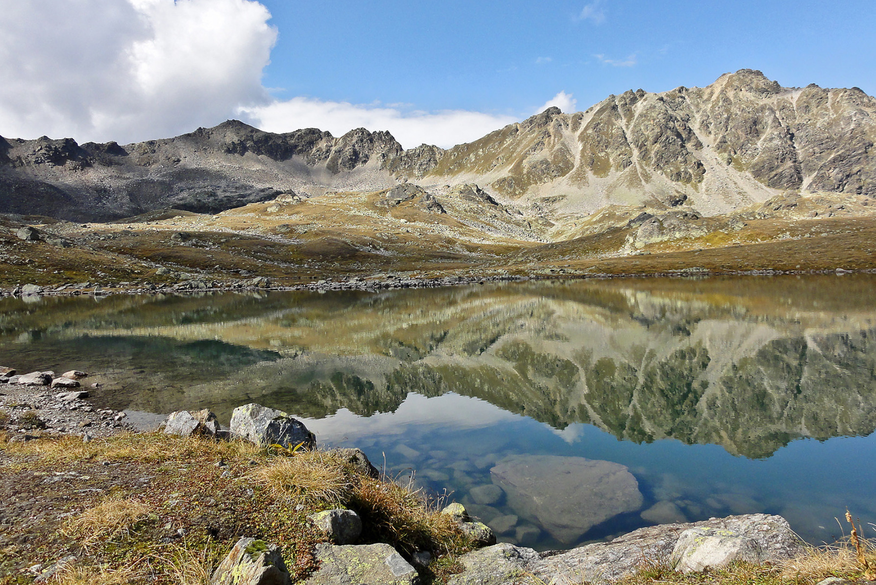 Die Seenplatte «Lais da Macun» © Niculin Meyer
Pictures from the tour, made by various logging geocachers
Tour-Fotos, gemacht von diversen loggenden Geocachern.
LOG REQUIREMENT / TASK 
🇬🇧 ENGLISH
To complete this task you will need to climb the mountain upto the altitude of 2945m / 9662ft and take two pictures in two specific places.
- Go to the coordinates (pictures from other spots will not qualify, but are as addition more than welcome)
- Take a picture as per example picture. The picture MUST contain following elements:
- The triangulation point
- The red cross
- The yellow marking
- Your GPS
- A paper (or the summit book) with your cacher name and date
- View of the lakes (at least 5 lakes visible)
- Seek the shown, distinct Stone in the Macun plateau and make a picture of it together with your GPS (or face)
- Upload the pictures with your log. Logs with no or non-compliant photos will be deleted
🇨🇭DEUTSCH
Um diese Aufgabe zu erfüllen, musst Du auf einen Berg steigen. Dieser hat die Höhe von 2945müM. Du musst zwei Bilder an zwei bestimmten Orten aufnehmen.
- Gehe zu den Koordinaten (Bilder von anderen Orten sind nicht qualifiziert, aber zusätzlich sehr willkommen)
- Mache ein Foto wie auf dem Beispiel. Das Photo MUSS folgende Elemente aufweisen:
- Den Vermessungspunkt
- Das rote Kreuz im Stein
- Die gelbe Markierung
- Dein GPS
- Ein Papier (oder das Gipfelbuch) mit Deinem Cachernamen und Datum.
- Aussicht auf die Seen (wenigstens 5 sollen sichtbar sein)
- Suche den gezeigten, markanten Stein auf der Ebene Macun und mache ein Foto davon mit Deinem GPS (oder Gesicht).
- Lade die beiden Bilder mit Deinem Log hoch. Logs mit keinem oder nicht-konformen Fotos werden gelöscht
🇬🇧 ENG: Logphoto 1 (showing the elements required)
🇨🇭DEU: Logfoto 1 (notwendige Elemente angezeigt)
🇬🇧 ENG: Logphoto 2 showing the stone to find
🇨🇭DEU: Logphoto 2 mit dem gesuchten Stein
ROUTE
🇬🇧 ENGLISH
The tough guys will start their tour in Zernez. Others might choose to use the (paid) transportation means starting at waypoint 01 and leading up to waypoint 02 at approximately 2220m. From there follow the indicated route up to Munt Baselgia / Macun. The route is marked as white-red-white mountain route, and characterized as "demanding". You absolutely need to have good mountain gear with you, and enough food / water as there is no service during all the route (You might find fountains when descending to Lavin)
Upon climbing your last 200m elevation you will find a passage with chains to help secure yourself. Depending on your experience and the weather conditions you might find them exagerated.
Descending we chose to follow the signs to Lavin. After Alp Zezna Dadaint (pt 1958) we turned to the left (west) and were overwhelmed by a beautiful, easygoing trail.
The national park tourist center recommends this tour for children starting 10 years of age, provided they are experienced.
Expect the pure walking time to take 5 - 6 hours. Starting at WP02, the overall metrics measured are about 800m up and 1600 down and 16Km hiking trail.
🇨🇭DEUTSCH
Die harten Jungs und Mädels starten ihre Tour in Zernez. Andere können sich dafür entscheiden, das (kostenpflichtige) Transportmittel vom Wegpunkt 01 bis zum Wegpunkt 02 auf ca. 2220 m zu benutzen. Von dort aus folgst Du der angegebenen Route bis zum Munt Baselgia / Macun. Die Route ist als weiss-rot-weisser Bergweg markiert und als "anspruchsvoll" bezeichnet. Du brauchst unbedingt eine gute Bergausrüstung und genügend Proviant / Wasser, da es auf der ganzen Strecke keinen Service gibt (Beim Abstieg nach Lavin finden sich evtl einzelne Brunnen)
Auf den letzten 200 Aufstiegs-Metern findet sich eine Passage mit Ketten, um sich zu sichern. Abhängig von Deiner Erfahrung und den Wetterbedingungen wirst Du diese als übertrieben empfinden.
Beim Abstieg folgten wir den Schildern nach Lavin. Nach der Alp Zezna Dadaint (pt 1958) bogen wir nach links (Westen) ab und wurden von einem schönen, leicht begehbaren Weg überwältigt.
Das Nationalpark-Touristenzentrum empfiehlt diese Tour für Kinder ab 10 Jahren, vorausgesetzt, sie sind erfahren.
Erwarte, dass die reine Gehzeit 5 - 6 Stunden beträgt. Wenn Du bei WP02 startest, sind es 800 Höhenmeter hoch und 1600 runter die es zu bezwingen gilt sowie 16km Fussmarsch (Start bei WP02)
PROTECTION REGULATIONS / VERHALTENSREGELN 
🇬🇧 ENGLISH
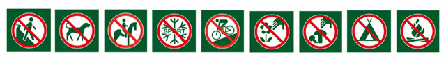
Extract from the National Park regulations:
- it is strictly forbidden to leave the marked paths
- no litter
- no natural object may be picked or removed: animals, plants, sticks, stones, etc.
- dogs are not allowed in the Park, not even on a lead
- no winter sports, cycling or flying of any sort are permitted
- bathing in lakes, pools, streams and rivers is not permitted
- no camp fires
- overnight stays are strictly forbidden, including in parked vehicles alongside the main Pass dal Fuorn (Ofenpass) road
- Nature must be left undisturbed
Park wardens are present to enforce the maintenance of the Park regulations and it is their duty to report any contraventions.
Around 150,000 people visit the Park each year; only if each visitor respects these regulations will everyone have an equal chance to observe the wonders of nature – now and for years to come.
🇨🇭DEUTSCH
Auszug aus dem Nationalpark Reglement
- Die markierten Wanderwege dürfen nicht verlassen werden
- Keinerlei Abfälle liegenlassen
- Naturgegenstände wie Tiere, Pflanzen, Hölzer oder Steine dürfen nicht mitgenommen werden
- Kein Mitführen von Hunden, auch nicht an der Leine
- Keine Wintersportarten (Ski- oder Schneeschuhtouren), Fahrräder oder Fluggeräte
- Kein Baden in Seen und Bächen
- Kein Feuer machen (Waldbrandgefahr!)
- Kein Übernachten, auch nicht in Fahrzeugen entlang der Ofenpassstrasse
- Die Natur darf nicht verändert werden
- Die Verwendung von Drohnen ist ebenfalls verboten
RESOURCES 
🇬🇧 ENGLISH
🇨🇭DEUTSCH

VIRTUAL REWARDS 2.0 - 2019/2020
This Virtual Cache is part of a limited release of Virtuals created between June 4, 2019 and June 4, 2020. Only 4,000 cache owners were given the opportunity to hide a Virtual Cache. Learn more about Virtual Rewards 2.0 on the Geocaching Blog.

 |