To get credit for this earthcache you must message the cache owner the answers to questions 1-3. For task 4, upload the required photo into the cache page gallery.
1.) Examine the full span of the American Falls then speculate as to where you think the next rockslide will occur (left side, center, right side). Describe what you see that leads you to that conclusion.
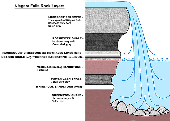
2.) How many different rock layers make up the composition of the American Falls?
3.) What is the talus, which makes up part of the American Falls?
4.) Post a photo in the cache page gallery of you or your signature item in front of the American Falls. This will serve as your log signature.
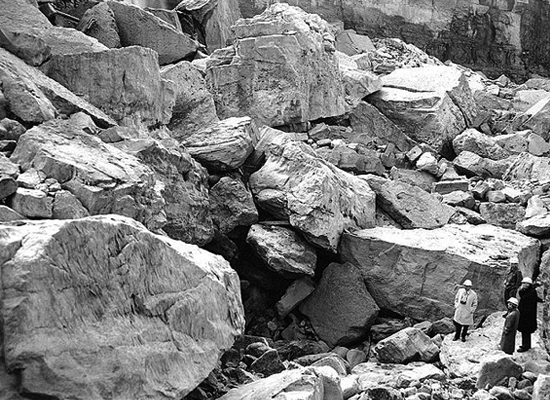
When you view the American Falls, which is located directly across the gorge from Ground Zero , you will see an immense rock pile at its base that was caused by several rockslides over the years. The last 3 slides occurred in 1931, 1954 and 1959 with the 1954 slide being caught on film. (video) Niagara Falls Rockslide 1954
The reason for the frequency of these slides is due to the unstable geological makeup of the Falls. Beneath the flowing waters there are several different types of rock layers. Since the densest of these different layers lies on top with the softer layers below, water erodes the lower layers causing the much harder top layer to break off and fall into the gorge. This sloping pile of rocks formed by the slides is called a talus.
.
.
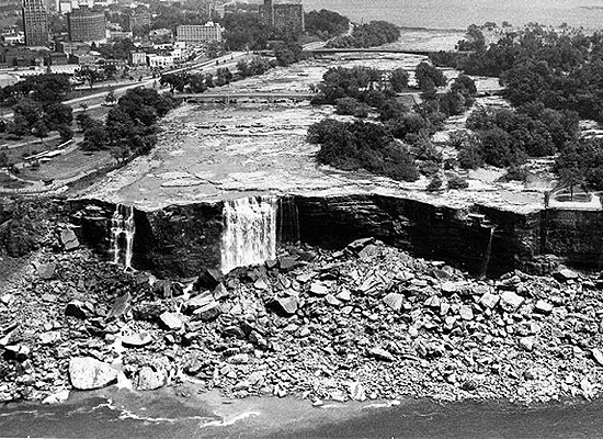
In 1969 the American Falls were temporarily shut off, or dewatered, in order for scientists to study the geological composition and to see if there was a way for them to slow down the aggresive erosion that was taking place. (video) The Stopping of Niagara Falls 1969
.
.
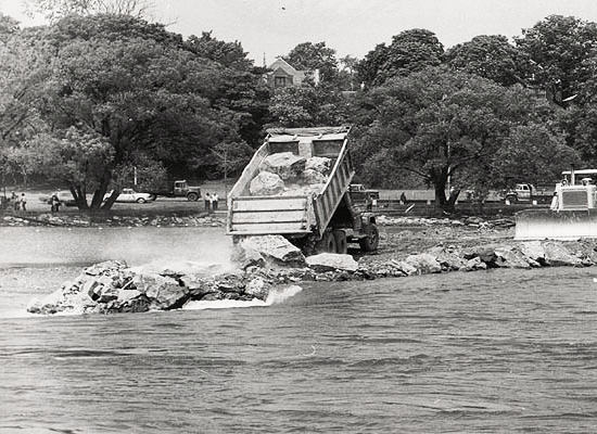
Engineers built a temporary cofferdam using 27,800 tons of rock and earth that was deposited by truck between the City of Niagara Falls USA and Goat Island to achieve the falls dewatering.
.
.
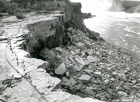
During the shutdown of the water the Rochester Shale on the rock face started to crumble so geologist had 800 feet of water pipe laid in order to water the shale and keep the moist.
.
.
While the water flow was stopped, geologists studied the rock types, which included chemical analysis and microscopic inspections in order to learn reasons why various rock types were susceptible to the weathering process, to determine the strength of the joints between the rocks above the Falls and to study the strength of the rocks at low temperatures. A multitude of core samples were taken during this process.
.
.
After compiling all of the geologic and engineering data, the determination was that it was currently not feasible to persue any specific course of action and to allow nature to take its course. During the project, several sensors were installed to monitor pressure changes and rock movement for future determinations.
CONGRATULATIONS to mweeg for being the First to Find.

Stop by our Geocaching Central web site. It's jam packed with geocaching goodness.
.