English description below
Diese Challenge, zu der ich Euch herausfordere, ist von Hannover aus nicht so einfach zu erfüllen, aber dennoch innerhalb von Deutschland machbar: Eure Aufgabe ist es, genug Caches zu finden, so dass ihr für jedes mögliche Höhenmeterintervall in Eurer project-gc-Statistik mindestens einen Fund geloggt habt.
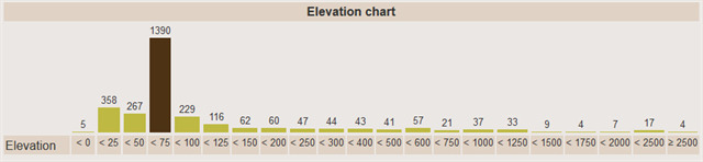
Welche Intervalle dies sind, könnt ihr hier sehen (Snapshot meiner Statistik am Osterwochenende 2019):
Eure Statistik könnt ihr Euch auch so anzeigen lassen. Verwendet dazu die folgende URL:
https://project-gc.com/ProfileStats/Dein Cachername .
Logbedingungen:
- Findet Caches in jedem der oben gezeigten Höhenintervalle.
- Weist dies durch diesen Checker, der bei project-gc gehostet wird, nach. Ihr könnt das Ergebnis in Eurem Log dokumentieren, dies ist keine Pflicht, aber würde mich freuen.
- Findet den Cache vor Ort (gepostete Koordinaten) und signiert das Log.
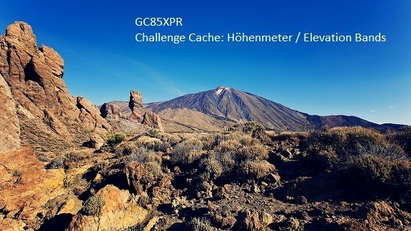
Ich würde mich weiterhin freuen, wenn ihr mir schreibt, welches der höchste Cache, den ihr gefunden habt und wie es dazu kam. Mein höchster gefundener Cache liegt auf dem Pico del Teide (Teneriffa, Spanien), der auf dem Hintergrundbild zu sehen ist.
English description
This challenge, to which you are cordially invited, requires that you find a enough caches so that your project-gc-statistics show at least one find in each height interval (see diagram above).
Your statistic can be accessed via:
https://project-gc.com/ProfileStats/Your cachername .
Logging requirements:
- Find caches in each of the above elevation bands.
- Confirm this by using the provided checker, hosted by project-gc. You may include the output in your log; this is optional but appreciated.
- Then you may log the cache which can be found at the posted coordinates.
I would appreciate if you can name and describe your highest find. My highest find was on Pico del Teide in Tenerife, Spain, which you can see in the background image. I found the traditional cache near the teleferique station at the top.

Banner:
<a href="http://coord.info/GC85XPR"><img src="https://s3.amazonaws.com/gs-geo-images/ab25dba6-457a-4c39-a42f-1aade3b3d00d_l.jpg" /></a>