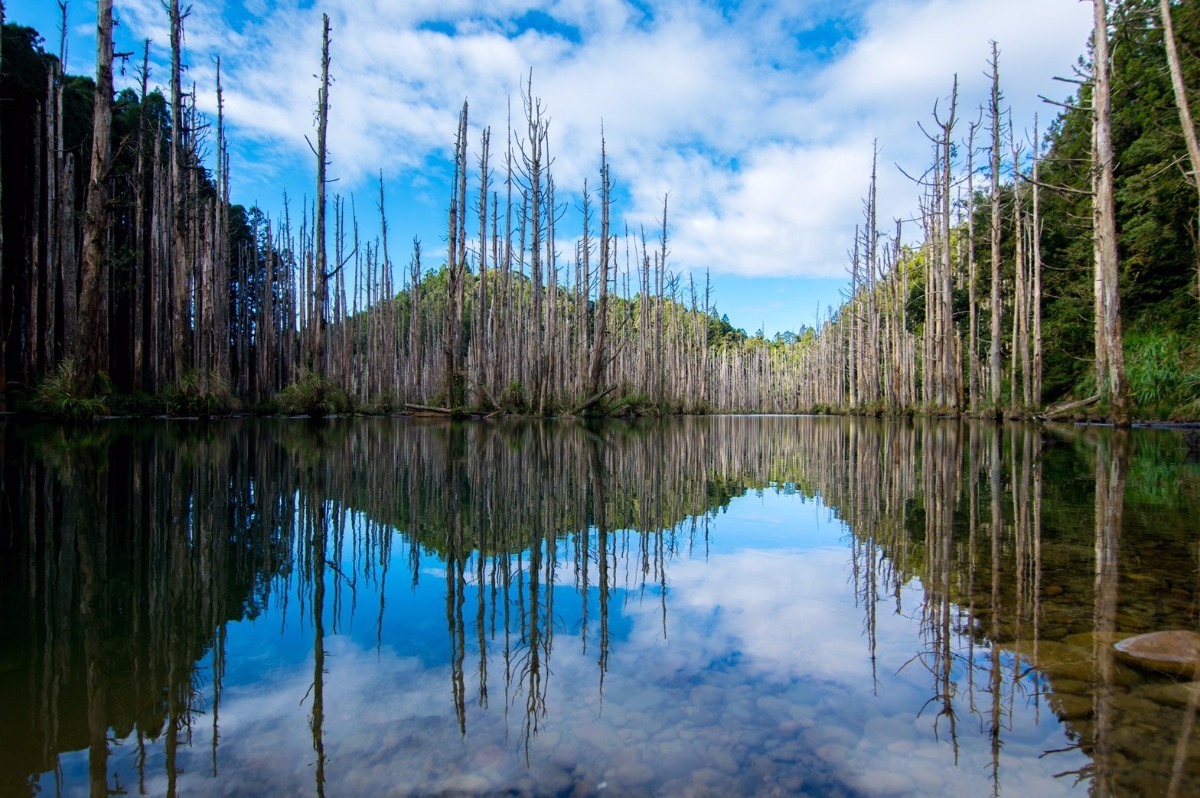
Come see a part of Taiwan reshaped by the forces of Mother Nature;
A lake formed by the power of an earthquake that left lifeless trees a featured.
Sit and take in the beauty before your eyes of this place once a woodland
Reach into that tree there to find another treasure that sits so grand.
Important Information about this Hike:
The Terrain Level for this cache are set at 5 if starting from Waypoint 5. Also, the Attributes reflect the starting point of Waypoint 5 as well. However, if you want a less challenging Terrain Level of 3, you can enter from Waypoint 7. Since my buddy and I hiked from Waypoint 5 on over to Shuiyang, I am keeping the Terrain setting at 5 with the respective Attributes. So even if you follow the "easier" route of entering in from Waypoint 7 and make it to Shuiyang that way to find the Geocache, you will still get credit for finding a T5 Cache. Sweet deal!
Information about the T5 Hike:
The distance from the trailhead (Waypoint 5) to Shuiyang is around 11 kilometers, and can be done anywhere from six to nine hours depending on breaks and other stops to find the Geocaches along the trail. This trail has a lot of steep ascents that require you to use ropes or tree branches to pull yourself up. Also, there are two points along this path that require you to cross rivers — the first one is more of a stream-like body of water that you will come to about two kilometers into the hike. Depending on how much rainfall there has been in this area, the current could be quite strong or just a little trickle. When my buddy and I hiked here on July 13th, 2019, the rocks were very slippery and the current was quite strong and we could not find a safe place to cross since a lot of the rocks were too slippery or too deep under the water so we had to improvise by building our own path to cross the river. We found nearby rocks to throw into the river to create somewhat of a walkway, which helped us eventually get across (with very wet shoes and socks!). So be prepared for some improvisation if you meet the same situation at this point. The second river is quite wide but has huge boulders everywhere that make for a less challenging crossing than the first one. However, those boulders can still be slippery as well so please be careful when crossing. After you cross the second river, there is one final steep ascent up and a little walk before making it to the west side of the lake. Continue to follow the trail banners and you will eventually make it to the northeast part of the lake where you can set up camp. As emphasized before, this entire trail from Waypoint 5 to Shuiyang is quite challenging but is well marked with trail banners tied to trees so make sure to always keep an eye out for these to make sure you are going in the right direction. If you come to a fork in the trail, pay attention to the trail banners as they will guide you in the safest route to Shuiyang. This T5 Hike may seem quite daunting but it is so much fun and so rewarding so please enjoy!
Information about the T3 Hike:
The distance from the trailhead (Waypoint 7) to Shuiyang is around 10 kilometers and can be done in around five to six hours. The first part of the trail follows more of an old road style trail that slowly ascends, and is very well maintained. There are many sections of plant overgrowth, however, that block the trail or make it difficult to see the trail at times but these sections are still easy to just walk through, pushing the plants to the side and making your way past these areas. There will be very small streams here and there to pass but nothing too overly challenging. There will be one steep ascent up and then one steep descent down before getting to Shuiyang. Overall, this trail is less challenging and much more popular than the T5 route. When my buddy and I hiked to Shuiyang, we came in via the T5 way, taking around nine hours to get to the lake, and when we exited, we went through the T3 way, only taking three and a half hours. So, this trail is a much easier way to go. Also, the trail is very well marked with trail banners as well and easily navigable. The T3 route was a pleasant surprise after the experience of doing the T5 hike the day before so you could also consider doing this when you come to Shuiyang — enter from Waypoint 5 and exit from Waypoint 7.
Miscellaneous Information
There are many other trails in this area and also some other routes that lead to Shuiyang. The two that I have referenced (T5 and T3) are the only two that I have done so I am unable to accurately access the condition of those other trails and can only base my understanding of them from what I read about online. I would recommend either of the two routes I have mentioned above. Also, it is strongly advised to download an offline hiking app and plan the route using a hiking program prior to going. My buddy and I did not come across any other hikers at all along the T5 route until we made it to the west side of the lake. However the T3 route had lots of groups coming in. So please plan to come here with a buddy and let people know where you are going. Remember, safety first!
The geocaches along the T5 route were placed as a way to give the adventurous Geocacher somewhat of a tangible reward for undertaking and completing such a challenging hike. I did not place those geocaches there to put people's lives in danger so please be responsible and understand the nature of the T5 hike if you wish to go that same route to Shuiyang. Otherwise, if you feel the T5 route is too much and you may not be physically fit enough for it, by all means do not push yourself to try. The T3 route is much tamer and doesn't require as many challenges.
No matter which route you take, it is strongly suggested to start early and bring enough food, water, and other supplies necessary for an overnight trip. (The trip can be done in a day but you will be pushing it as you'll need 12+ hours to complete it.) Most people will spend one night at the lake so make sure to bring your own tent and sleeping bag too of course. One last thing is you will need to get a hiking permit to enter this area. You can apply for one by clicking on the website here. Unfortunately the website is only in Chinese at the moment so please ask a native speaker of Chinese to assist if you need help applying for a permit. I hope you all enjoy this wonder of Mother Nature as much as I did! Long Live Geocaching!