El Calderon Spring
By Carrot Killer and LadyBlackCat
English
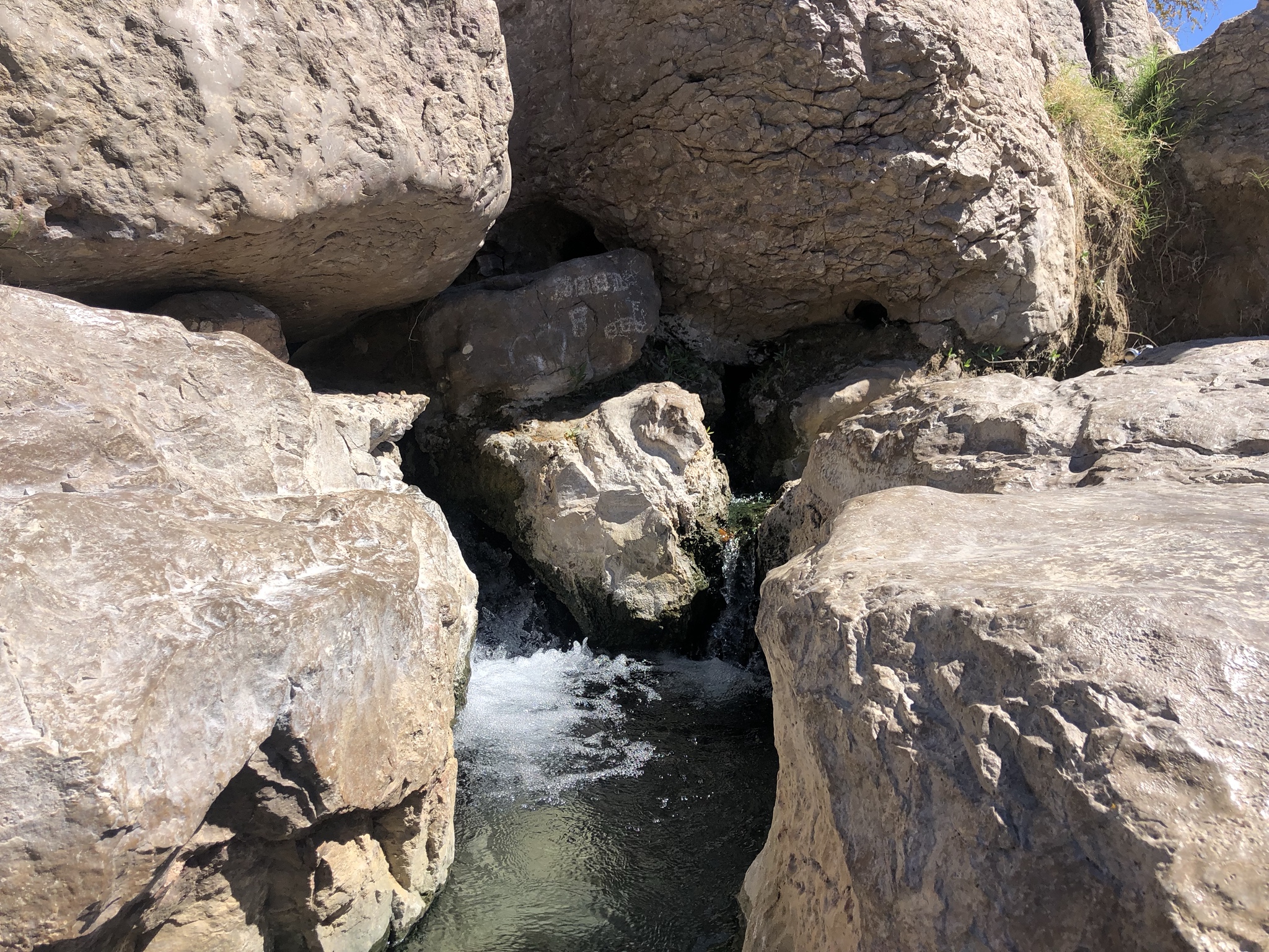
Located just across the Mexican border in the small village of Boquillas you can find a natural hot spring! The spring is fed by geothermally heated ground water which is seeping up from the earth's crust. The source of the heat is basin and range province which is an extension of the Rio Grande Fault. There is deep circulation of ground water in an area of relatively high thermal gradient. Recent volcanism is not a source of heat because, based on both paleontologic and isotopic evidence, the youngest observed igneous activity in West Texas is Miocene. Most hot springs lie on or immediately basinward of normal faults, at the edges of late Tertiary basins formed by east-west extension. This setting implies that faults are permeable channelways which allow thermal water to rise from below. Recharge for the thermal systems probably occurs in adjacent highlands. However, hot springs are not restricted to faults with large displacement or to particular rock types. Many faults do show evidence of recent movement, which may be important in keeping fracture systems permeable. The temperature of this water you will find is much warmer than that of the nearby Rio Grande River. In order to be classified as a hot spring the water which is emitted must be a higher temperature than the air temperature around it. That is easily the case here.
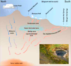
Typically the water from a hot spring gets hotter the deeper it travels down. If there is a "crack" in the earth's crust it can release a tremendous amount of heat. The closer the water gets to magma the warmer the water will be when it returns to the surface. The water will travel up through the rocks and will eventually be emitted out into the surface. Three thermal systems, the two Gulf Wells in Texas and Ojos Calientes in Mexico, have higher subsurface temperatures, ranging from at least 100°C up to possibly 160°C. According to the geologic setting and geothermometry of hot spring systems, the most promising area for geothermal energy is the Presidio Graben, an actively subsiding basin along the Rio Grande. This area has the densest concentration of hot springs and wells and the highest surface and subsurface temperatures(90°C and 160°C, respectively). The high temperatures result from deep circulation of meteoric water in a region with high thermal gradient caused by crustal thinning. Hueco Bolson south of El Paso is in a similar geologic setting, but hot springs are found in only one area and have moderate (approximately 60°C) subsurface temperatures. Other areas are not as promising for geothermal development as Presidio and Hueco Bolsons. Although it has many hot springs, the Big Bend area has low subsurface temperatures and no evidence of recent faulting. Hot springs in Big Bend are probably a result of relatively shallow circulation in an area of normal heat flow. Now the ground water here has a somewhat unique chemistry. You may notice the many bubbles in the water that look almost like a soda when you put it in a glass. These bubbles are not simply the result of gas traveling to the surface. This water contains calcium carbonate, calcium sulfate, sodium sulfate, sodium chloride, and lithium. The presence of these minerals may be the reason these waters were believed to have a healing quality in the past.
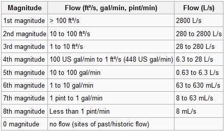
Water flowing from any spring is the result of an underground aquifer becoming so full that the water flows out to the ground. Above you will see the different categories or magnitudes of flow. These can vary quite a bit. Use the chart above to aid you in assessing the magnitude of flow here at this spring.
In order to log this earthcache please answer the following questions.
1) How many sources of the spring can you spot in the surrounding area?
2) What is the greatest magnitude of flow that you witnessed at this site?
3) What do you believe the heat source is for the spring?
4)(OPTIONAL) - Please include a photo of you or your group at the spring!
Thanks for taking time to check out this very cool spot!
Espanol
Ubicado al otro lado de la frontera mexicana en el pequeño pueblo de Boquillas, ¡puedes encontrar una fuente termal natural! El manantial es alimentado por agua subterránea calentada geotérmicamente que se filtra desde la corteza terrestre. La fuente del calor es la provincia de cuenca y rango, que es una extensión de la falla del Río Grande. Existe una circulación profunda de agua subterránea en un área de gradiente térmico relativamente alto. El vulcanismo reciente no es una fuente de calor porque, según la evidencia paleontológica e isotópica, la actividad ígnea más joven observada en el oeste de Texas es el mioceno. La mayoría de las aguas termales se encuentran en las fallas normales o inmediatamente hacia la cuenca, en los bordes de las cuencas terciarias tardías formadas por la extensión este-oeste. Esta configuración implica que las fallas son canales permeables que permiten que el agua termal suba desde abajo. La recarga para los sistemas térmicos probablemente ocurre en las tierras altas adyacentes. Sin embargo, las aguas termales no están restringidas a fallas con grandes desplazamientos ni a tipos de rocas particulares. Muchas fallas muestran evidencia de movimiento reciente, que puede ser importante para mantener los sistemas de fractura permeables. La temperatura de esta agua que encontrará es mucho más cálida que la del cercano río Grande. Para ser clasificado como una fuente termal, el agua que se emite debe tener una temperatura más alta que la temperatura del aire a su alrededor. Ese es fácilmente el caso aquí.
Por lo general, el agua de una fuente termal se calienta cuanto más profundo desciende. Si hay una "grieta" en la corteza terrestre, puede liberar una gran cantidad de calor. Cuanto más se acerque el agua al magma, más caliente estará cuando regrese a la superficie. El agua viajará a través de las rocas y eventualmente se emitirá a la superficie. Tres sistemas térmicos, los dos pozos del Golfo en Texas y Ojos Calientes en México, tienen temperaturas más altas en el subsuelo, que van desde al menos 100 ° C hasta posiblemente 160 ° C. De acuerdo con el entorno geológico y la geotermometría de los sistemas de aguas termales, el área más prometedora para la energía geotérmica es el Presidio Graben, una cuenca que se hunde activamente a lo largo del Río Grande. Esta área tiene la concentración más densa de aguas termales y pozos y las temperaturas más altas de superficie y subsuperficie (90 ° C y 160 ° C, respectivamente). Las altas temperaturas son el resultado de la circulación profunda del agua meteórica en una región con un alto gradiente térmico causado por el adelgazamiento de la corteza. Hueco Bolson, al sur de El Paso, se encuentra en un entorno geológico similar, pero las aguas termales se encuentran en una sola área y tienen temperaturas moderadas (aproximadamente 60 ° C) debajo de la superficie. Otras áreas no son tan prometedoras para el desarrollo geotérmico como Presidio y Hueco Bolsons. Aunque tiene muchas aguas termales, el área de Big Bend tiene bajas temperaturas debajo de la superficie y no hay evidencia de fallas recientes. Las aguas termales en Big Bend son probablemente el resultado de una circulación relativamente poco profunda en un área de flujo de calor normal. Ahora el agua subterránea aquí tiene una química algo única. Puede notar las muchas burbujas en el agua que se ven casi como un refresco cuando lo coloca en un vaso. Estas burbujas no son simplemente el resultado del gas que viaja a la superficie. Esta agua contiene carbonato de calcio, sulfato de calcio, sulfato de sodio, cloruro de sodio y litio. La presencia de estos minerales puede ser la razón por la cual se creía que estas aguas tenían una calidad curativa en el pasado.
El agua que fluye de cualquier manantial es el resultado de un acuífero subterráneo que se llena tanto que el agua fluye hacia el suelo. Arriba verás las diferentes categorías o magnitudes de flujo. Estos pueden variar bastante. Use la tabla de arriba para ayudarlo a evaluar la magnitud del flujo aquí en esta primavera.
Para registrar esta tierra, por favor responda las siguientes preguntas.
1) ¿Cuántas fEl agua que fluye de cualquier manantial es el resultado de un acuífero subterráneo que se llena tanto que el agua fluye hacia el suelo. Arriba verás las diferentes categorías o magnitudes de flujo. Estos pueden variar bastante.
uentes de la primavera puedes observar en el área circundante?
2) ¿Cuál es la mayor magnitud de flujo que presenciaste?
3) ¿Cuál crees que es la fuente de calor para la primavera?
4)) OPCIONAL - ¡Incluya una foto suya o de su grupo en la primavera!
Gracias por tomarse el tiempo para ver este lugar tan genial!