INTRODUCTION
Quarry Knowe is a quiet, picturesque area of Victoria Park famous for containing a group of 325 million year old fossilised lycopod trees from the Carboniferous Period, called the Fossil Grove. The fossils are housed within a small but informative visitor centre which is open, free of charge, at weekends during the summer months and is well-worth visiting if you can.
Although the fossils themselves are undoubtedly the star attraction of this site, the focus of this Earth Cache is on the wider geological history of the area. It will take you on a short walking tour of the site and can be completed in around 20 minutes at any time of day or year.
This EarthCache has been placed in collaboration with the Geological Society of Glasgow, the Strathclyde Geoconservation Group and the Fossil Grove Trust. For further information on the Fossil Grove, please visit: www.fossilgroveglasgow.org and for more general information see: www.geologyglasgow.org.uk/
HISTORY AND GEOLOGY
During the Carboniferous Period, 325 million years ago, Scotland was situated close to the equator and the area now occupied by Quarry Knowe and the Fossil Grove was a swampy forest of lycopod trees. These trees were similar to (though much larger than) modern clubmosses with distinctive hollow trunks and unusual root systems that divide equally and symmetrically. Nearby a major river system existed, comparable in scale and form to the modern rivers draining the Himalayas, with several very wide but interconnected channels.
The trees growing in the Fossil Grove were killed when one of the nearby river channels burst its banks and the area was inundated by a series of fast flowing floods, probably similar in scale to those that affected the city of New Orleans following Hurricane Katrina in 2005. Over time, these river channels (and the associated flood events) deposited layers of sand, silt and mud that were buried to a depth of a few kilometres. The higher pressures and temperatures found at these depths squeezed the water out of the sediments and eventually turned them into sedimentary rocks called sandstone, siltstone and mudstone.
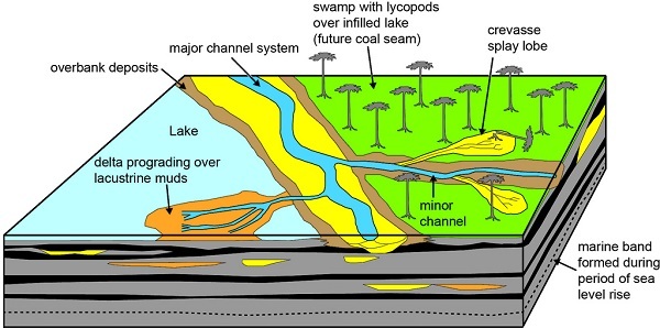
Schematic model of the depositional systems prevalent in the Fossil Grove area 320 million years ago. A minor channel has been breached during a flood and has deposited a sand-bed over the swamp, knocking down trees in the process. This is how the Fossil Grove formed.
Sedimentary rocks often consist of distinct layers, called beds, that are associated with the different layers of sediment that were originally deposited to create them. A detailed examination of these beds, focusing on their orientation, thickness and grain size, can reveal a great deal about the environment in which they were formed and the processes that have shaped them since. For example, although sediments are usually deposited in horizontal layers, it is sometimes possible to see sedimentary beds that are inclined at an angle to what was once the horizontal. One environment where this sloping sedimentary rock can form is along the sloping sides of an ancient river channel. It is also relatively common to see inclined “cross-beds” inside the main beds; these are the result of flowing water (or, sometimes, wind) creating sand dunes.
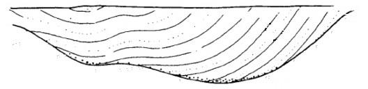
Inclined sedimentary beds lining the sides of an old river channel.
Water flow is in to (or out of) the diagram.
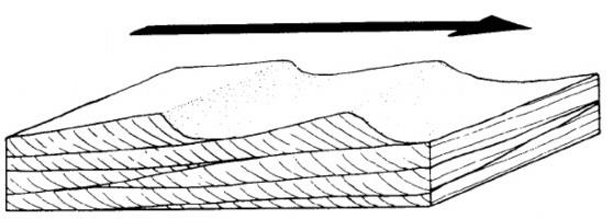
Inclined “cross-beds” inside the main horizontal beds at the bottom of a river.
Water flow is from left to right.
Around 30-35 million years after the deposition of these sedimentary rocks, the Quarry Knowe area became both volcanically and tectonically active. Magma forced its way between some of the pre-existing sandstone beds, eventually solidifying to form layers of buried igneous rock, called a sill. In this area we do not see any surface volcanic features. In addition to this, many fault lines (fractures along which rocks can slip and slide past each other, triggering an earthquake) subsequently developed throughout the Glasgow area as a result of a major mountain building episode which was taking place in southern Britain.
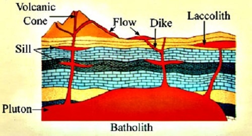
Diagram showing the formation of an igneous sill during a period of volcanism.
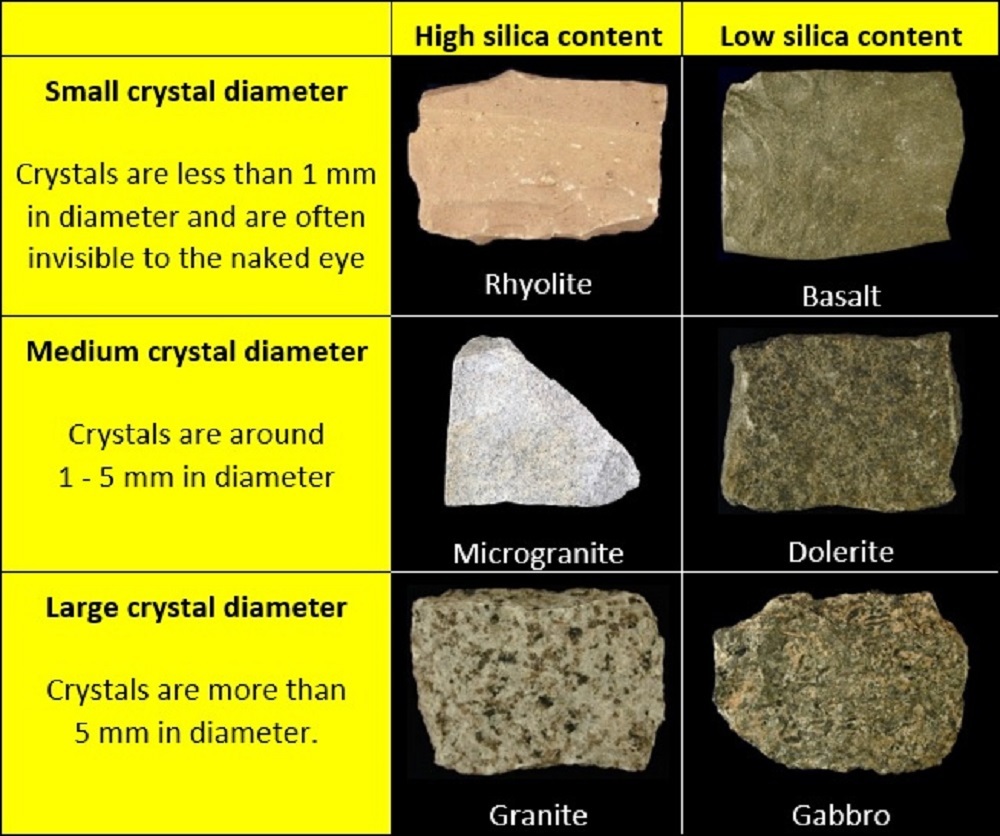
Igneous rocks are generally more resistant to weathering than sedimentary rocks, tend not to have layers, and often contain distinct crystals that formed as the magma cooled. The size and chemical composition of these crystals can reveal a great deal about the history of the magma from which the rock was formed. For example, magma that erupts onto the surface typically cools quickly and forms rock with very small crystals whilst magma that cools underground typically cools slowly and forms rock with much larger crystals. Meanwhile, silica-rich magmas (typically formed at shallow depths, just underneath the Earth's crust) go on to form light-coloured rocks such as granite whilst silica-poor magmas (typically formed deeper inside the Earth's interior) go on to form darker-coloured rocks such as basalt. The size and chemical composition of the crystals found in igneous rocks are related to the major sub-groups of the rock, as shown in the table below:
By the modern age, gradual erosion of the overlaying sandstone layers had exposed some of the igneous sill on the surface and a quarry was opened to extract the igneous material for roadstone. When the quarry closed in the late 19th century, the area was redeveloped as a public park and it was during this redevelopment that the fossilised trees were found. Today, Quarry Knowe is maintained by the Land and Environmental Services Department of Glasgow City Council (with support from the Fossil Grove Trust) and the contents of the Fossil House itself are designated a Site of Special Scientific Interest.
SITE MAP
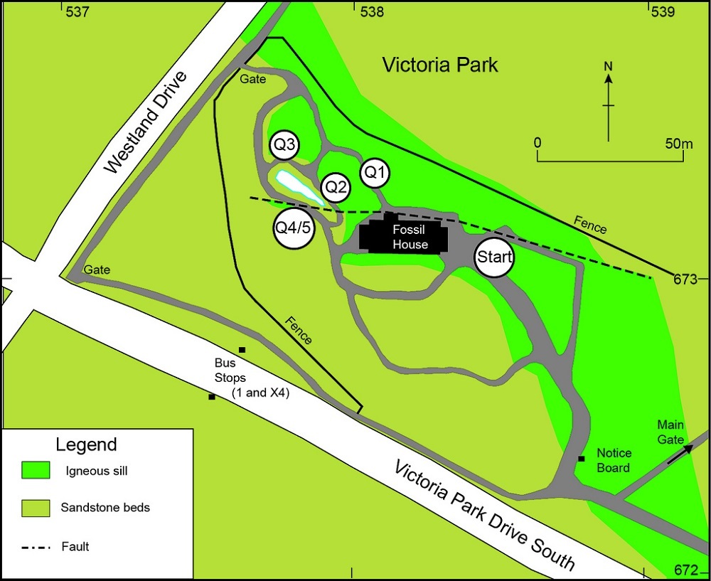
The cache coordinates place you in the middle of the old quarry and near to the main entrance to the Fossil House. Proceed to the right (north) of the building and head down the gorge (or defile) to your right. The gorge cuts straight through the middle of the now-exposed igneous sill, revealing the sill to be (at least) several metres thick.
QUESTION 1
A good place to look at the rock making up the igneous sill can be found at head height, towards the end of the gorge on the left-hand side. If you inspect this area closely, you will be able to see some of its crystal structure. The paler, off-white to buff crystals are of feldspar and the rusty brown ones are pyroxene and olivine - now weathered to iron oxides and other minerals. The small holes are where carbonate minerals have weathered out. The presence of these minerals shows that the rock has a relatively low silica content.
What sub-group of igneous rock do you think the sill is formed of? Explain your answer by referring to the size and chemical composition of the crystals.
QUESTION 2
Continue through to the end of the gorge and turn left at the T-junction, heading down the steps towards the pond. Once you reach the pond, turn left again and proceed along the path about as far as you can. Most of cliff-face here is part of the same igneous sill you have just walked through but, around 1.5 - 2m from the ground there is a 20 cm thick horizontal band of a different type of rock. This band of rock is called a xenolithic raft. These rafts show that the intrusion of the igneous rocks was complex with magma forcing its way between the beds and effectively ‘jacking-up’ the sedimentary strata.
Compare the colour and texture of the rock that forms the xenolithic raft to that of the surrounding sill and, on the basis of your observations, suggest whether the raft is made of igneous or sedimentary rock.
QUESTION 3
Turn around and head back the way you came, passing the steps and continuing onwards to inspect the cliff-face on their other side of the steps. The upper section of this cliff is, again, part of the igneous sill while the lower section is composed of older sandstone. The boundary between the two rock types is well exposed here and the igneous rock immediately above the contact is very-fine grained (i.e you cannot see any crystals). This is a good example of a ‘chilled margin’ where the once-molten rock froze very quickly when it came in contact with the much colder sedimentary rock.
Does the boundary between the igneous and sedimentary rock slope down towards or away from the Fossil House?
If you can't tell which direction the boundary is sloping in, proceed to Q4 and look back at the cliff from the other side of the pond. The boundary line is often easier to see from this vantage point.
QUESTION 4
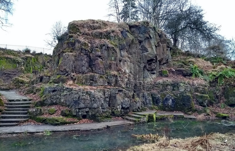
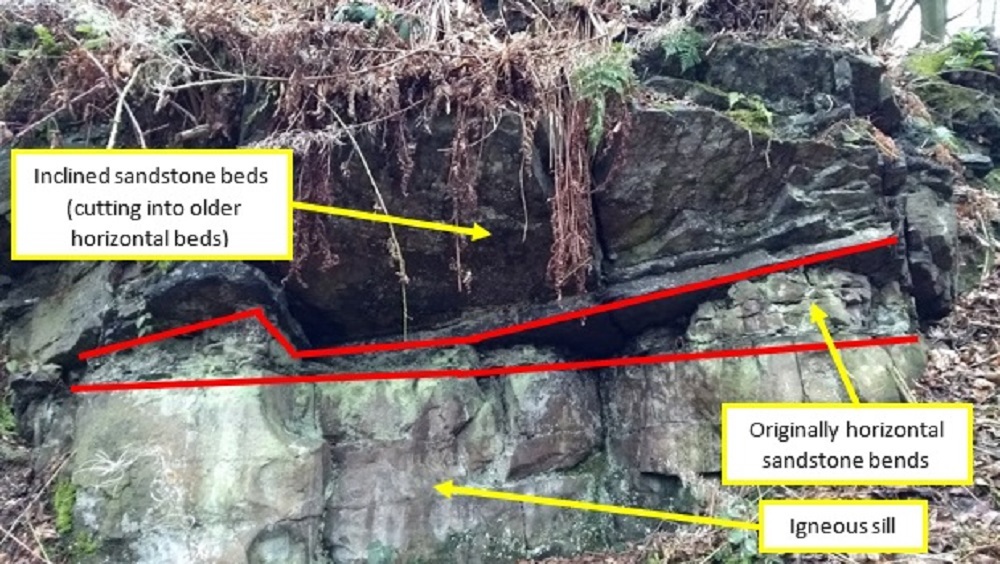
Finally, continue around to the other side of the pond and stop when you are opposite the steps. You are now standing next to another section of the igneous sill, though it can sometimes be hidden by vegetation, hence the accompanying photograph. Directly above the sill are some thin sandstone beds that were once (roughly) horizontal. However, cutting through these, there are some steeply inclined sandstone beds of varying angle. Around 100 metres away to the east, a similar formation has inclined beds that slope in the opposite direction.
What does the structure of the sandstone beds in this area tell you about the environment in which the associated sediments were deposited?
QUESTION 5
The base of the igneous sill in the area of questions 1-3 is around 2-3 metres lower than it is in this area, the Fossil House or the start coordinates for the cache. What do you think the origin of this offset could be?
LOGGING THE CACHE
When you log this EarthCache, feel free to include a photograph of your favourite part of the site (with or without yourself in it) and message the owner, either through email or via the Message Centre, with your answers to the five questions above. If there are any issues with your answers, I will contact you to discuss them. However, logs for which accompanying answers are not received (within 2 weeks of logging) will be deleted.
I hope you enjoy your visit to this EarthCache.