CASTELLANO
(OTHER LANGUAGES BELOW)
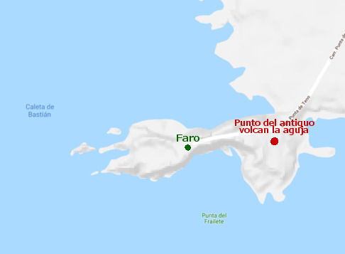
La punta de Teno se sitúa en el extremo mas al oeste de la isla de Tenerife, rodeado de barrancos y agua. En este lugar de difícil acceso se encuentra uno de los mejores lugares para observar la biodiversidad marina de la isla, además si el tiempo es favorable podemos ver las islas de La Palma y La Gomera en el horizonte. En esta punta podemos apreciar su aspecto "lunar" con el terreno volcánico que lo compone.
En este lugar únicamente hay una construcción de un faro, por lo que es importante ir preparados en cuanto a agua, ropa, y comida ya que carece de ningún tipo de tienda cercana. Dispone de parking cercano y si es posible recomendamos llevar gafas de buceo para hacer snorkeling en su playa.

Volcán activo saliendo desde el mar.
La formación de la Punta de Teno se debe a un cono volcánico que hubo hace miles de años, conocido como el volcán "La Aguja", sobresaliendo este desde el fondo marino y empezando a dar forma a este lugar.
Situación antigua del volcán.
El volcán de La Aguja además fue ganando terreno al mar mediante la solidificación de su lava en contacto con el agua, dando a si el inicio de este pico de tierra adentrándose en el mar Atlántico.
El resultado final a día de hoy en el que queda este entorno es debido principalmente a la erosión, ya sea del agua como del aire durante miles de años. Dejándonos un lugar así de espectacular como el que os mostramos en esta ubicación, en el que además se puede apreciar el cambio de color provocado por las olas en la roca.
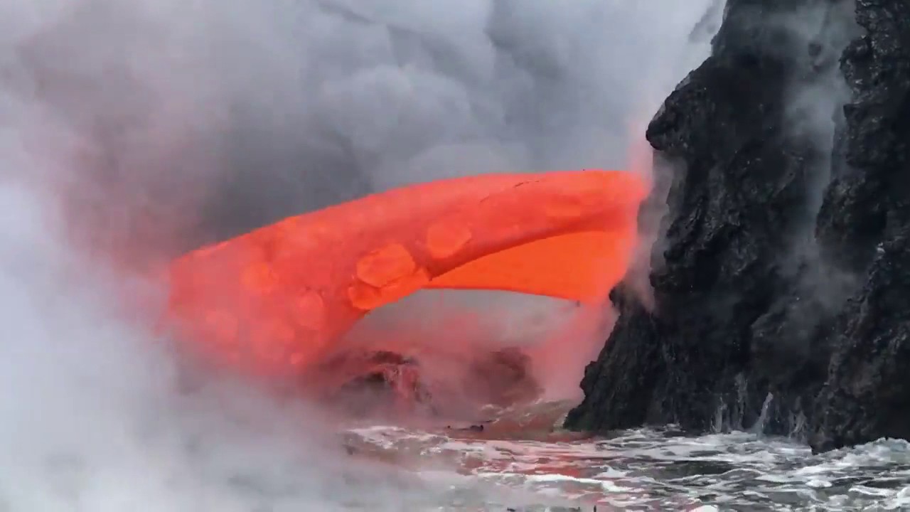 Lava solidificandose en contacto con el agua del mar.
PARA PODER HACER "FOUND IT" EN ESTE CACHÉ TENEIS QUE MANDARME UN MENSAJE PRIVADO CONTESTANDO A LAS SIGUIENTES PREGUNTAS:
1- ¿Cuales son los dos factores que influyeron para formar la Punta de Teno?.
2- Todo el suelo y paredes está formado por roca volcanica, al tacto ¿es suave o abrasiva?.
3- Fijate en uno de los pequeños barrancos donde rompen las olas, uno de los lugares donde mas se nota la erosion del mar, ¿oscurece o aclara la roca?.
4- Por comparación ¿Cuales son los colores que puedes visualizar de roca volcanica en este camino?
5- Opcional. Publica una foto con el faro tuya o algo que te identifique (Gps, papel con tu nick, gorra, muñeco...etc) como que has estado en el lugar, sin que en la foto salga ningún spoiler.
ENGLISH
(DEUTSCH UNTEN)
(FRANÇAIS APRÈS)
The point of Teno is located in the extreme west of the island of Tenerife, surrounded by ravines and water. In this place of difficult access is one of the best places to observe the marine biodiversity of the island, and also if the weather is favorable we can see the islands of La Palma and La Gomera on the horizon. In this point we can appreciate its "lunar" aspect with the volcanic terrain that composes it.
In this place there is only one construction of a lighthouse, so it is important to be prepared in terms of water, clothing, food and it lacks any kind of store nearby. It has parking not so far and if it possible we recommend to take diving glasses to snorkel on the beach.
Active volcano leaving from the sea.
The formation of the Punta de Teno is due to a volcanic cone that existed thousands of years ago, known as the "La Aguja" volcano, standing out from the seabed and beginning to shape this place.
Ancient situation of the volcano.
The La Aguja volcano also gained ground to the sea by solidifying its lava in contact with the water, giving the beginning of this peak of land wich enter the Atlantic Ocean.
Now at day, the final result in which this environment is left is mainly due to erosion of both air and water for thousands of years, leaving us a place as spectacular at it seen. Here we can apreciatte the color changing due to water
Lava solidifying in contact with sea water.
TO BE ABLE TO MAKE "FOUND IT" IN THIS CACHÉ YOU HAVE TO SEND ME A PRIVATE MESSAGE ANSWERING THE FOLLOWING QUESTIONS:
1- What are the two factors that influenced the formation of Punta de Teno?.
2- All the soil and walls are formed by volcanic rock, is it soft or abrasive to the touch?.
3- Look at one of the small ravines where the waves break, one of the places where the erosion of the sea is most noticeable, does it obscures or clarifies the rock?.
4- What are the colors that you can visualize of volcanic rock on this road?
5- Optional. Post a photo with the lighthouse or something that identifies you (Gps, paper with your nickname, hat, toy ... ) as you have been in the place, without any spoiler in the photo.
DEUTSCH
(FRANÇAIS SOUS)
Die Spitze von Teno liegt im äußersten Westen der Insel Teneriffa, umgeben von Schluchten und Wasser. An diesem schwer zugänglichen Ort ist einer der besten Orte, um die Artenvielfalt der Inseln zu beobachten. Wenn das Wetter günstig ist, können wir die Inseln La Palma und La Gomera am Horizont sehen. In diesem Punkt können wir seinen "Mond" -Effekt mit dem Vulkanland, aus dem es besteht, schätzen.
An diesem Ort gibt es nur einen Bau eines Leuchtturms. Daher ist es wichtig, sich auf Wasser, Kleidung und Lebensmittel vorzubereiten. In der Nähe gibt es keine Geschäfte. Es gibt Parkplätze in der Nähe und wenn möglich, empfehlen wir, Schnorchel am Strand mitzunehmen.
Aktiver Vulkan verlässt das Meer..
Die Entstehung von Punta de Teno ist auf einen vor Tausenden von Jahren existierenden Vulkankegel zurückzuführen, der als "La Aguja" -Vulkan bekannt ist und sich vom Meeresboden abhebt und diesen Ort zu formen beginnt.
Alte Situation des Vulkans.
Der Vulkan La Aguja gewann ebenfalls an Boden, indem er seine Lava in Kontakt mit dem Wasser erstarrte und den Beginn dieses Gipfels des in den Atlantik wirkenden Landes bildete.
Das Endergebnis heute, in dem diese Umgebung übrig bleibt, ist hauptsächlich auf die Erosion von Wasser und Luft über Tausende von Jahren zurückzuführen. Wir verlassen uns auf einen ebenso spektakulären Ort wie den, den wir Ihnen hier zeigen.
Lava, die sich in Kontakt mit Meerwasser verfestigt.
UM IN DIESEM CACHÉ "FUND IT" ZU MACHEN, MÜSSEN SIE MIR EINE PRIVATMELDUNG SENDEN, UM DIE FOLGENDEN FRAGEN ZU BEANTWORTEN:
1- Welche zwei Faktoren haben den Punta de Teno geprägt?.
2- Der gesamte Boden und die Wände sind aus Vulkangestein geformt, die Berührung ist weich oder abrasiv?.
3- Schauen Sie sich eine der kleinen Schluchten an, in denen die Wellen brechen, an einer der Stellen, an denen die Erosion des Meeres am deutlichsten spürbar ist, den Felsen verdunkelt oder verdeutlicht?.
4- Welche Farben können Sie auf dieser Straße vom Vulkangestein sehen?
5- Optional. Veröffentlichen Sie ein Foto mit Ihrem Leuchtturm oder etwas, das Sie identifiziert (Gps, Papier mit Ihrem Nick, Hut, Puppe usw.), während Sie an diesem Ort waren, ohne den Spoiler auf dem Foto.
FRANÇAIS
La pointe de Teno est située à l'extrémité Ouest de l'île de Tenerife, elle est entourée de falaises et d'eau. Ce site difficile d'accès est l'un des meilleurs endroits pour observer la biodiversité marine de l'île. Et si le temps le permet, nous pouvons voir les îles de La Palma et de La Gomera à l'horizon. En ce lieu, nous pouvons apprécier l’aspect "lunaire" du terrain volcanique qui le compose.
À cet endroit, il n’y a qu’une construction : un phare ; il est donc important d’être préparé et d’emporter suffisamment d’eau, de vêtements et de nourriture. En effet, il n’y a pas de magasin à proximité. Il y a un parking à proximité. Nous recommandons emmener avec soi des lunettes de plongée pour faire de la plongée avec tuba sur la plage.
Volcan actif sortant de la mer.
La formation de Punta de Teno est due à un cône volcanique qui existait il y a des milliers d'années, connu sous le nom de volcan "La Aguja", qui s’élève du fond marin et façonne cet endroit.
Ancien site du volcan..
Le volcan La Aguja a également gagné du terrain à la mer grâce à la solidification de la lave au contact de l'eau, créant ce pic de terre entrant dans l'océan Atlantique.
Aujourd’hui, l’état dans lequel cet environnement apparait est principalement dû à l'érosion, à la fois de l'eau et de l'air, pendant des milliers d'années. Nous laissant un endroit aussi spectaculaire que celui que vous pouvez découvrir.
Lave se solidifiant au contact de l'eau de mer.
POUR POUVOIR "TROUVER" CE CACHÉ, VOUS DEVEZ M'ENVOYER UN MESSAGE PRIVÉ RÉPONDANT AUX QUESTIONS SUIVANTES :
1- Quels sont les deux facteurs qui ont influencé la formation de la Punta de Teno ?.
2- Tout le sol et les parois sont formés de roche volcanique, au toucher est-ce doux ou abrasif?.
3- Regardez l’un des petits ravins où les vagues se brisent, l’un des endroits où l’érosion de la mer est la plus visible, la roche est-elle plus clair ou plus sombre?.
4- Quelles sont les couleurs de la roche volcanique que vous pouvez observer sur ce chemin?.
5- Facultatif. Publiez une photo avec le phare ou quelque chose qui vous identifie (GPS, papier avec votre pseudo, chapeau, poupée, etc.) pour confirmer que vous avez été sur place, sans faire de spoiler.
GRACIAS POR BUSCAR ESTE CACHÉ
THANK YOU FOR SEARCHING FOR THIS CACHÉ
MERCI DE RECHERCHER CE CACHÉ
DANKE FÜR DIE SUCHE NACH DIESEM CACHÉ
OBRIGADO POR BUSCAR ESTE CACHÉ
GRAZIE PER RICERCA PER QUESTA CACHÉ
СПАСИБО ЗА ПОИСК ЭТОГО КАШЕ
OSOKORBUTO