
A lineament is a linear feature in a landscape, which is an expression of an underlying geological structure such as a fault. Typically, a lineament will appear as a “line” in a satellite image or in the older aerial photos. For example, faults, dykes, lithological discontinuities, a straight coastline are typical.
Very large lineaments (e.g. the Great Glen Fault in Scotland or the San Andreas Fault) can be seen from space with the naked eye.

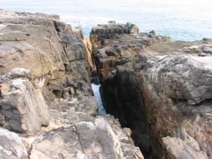
The earthcache that you are visiting has a recognizable linear feature on the landscape but in far more reduced scale than the examples shown above. You will be visiting a WNW-SSE orientated basic dyke with very particular features.
Note that you will need to be careful of the tides. Do not go there at night. On a sunny day take a beach towel and a camera and enjoy the place.
Definition of a dyke:
A dyke (or dike) in geology is a type of sheet intrusion referring to any geologic body that cuts discordantly across planar wall rock structures, such as bedding or foliation (see figure below).
Dykes are the escape routes of hot, molten magma from over pressurised magmatic chambers and provide an insight into the chemical composition of the magma at the time of intrusion into the surrounding country rock.
Intrusive dykes:
This EarthCache deals with intrusive dykes. An intrusive dyke is an igneous body with a very high aspect ratio, which means that its thickness is usually much smaller than the other two dimensions. Thickness can vary from sub-centimeter scale to many meters and the lateral dimensions can extend over many kilometers. A dyke is an intrusion into an opening cross-cutting fissure, shouldering aside other pre-existing layers or bodies of rock; this implies that a dyke is always younger than the rocks that contain it. Dykes are usually high angle to near vertical in orientation, but subsequent tectonic deformation may rotate the sequence of strata through which the dyke propagates so that the latter becomes horizontal.
Morphology of dykes:
Sometimes dykes appear as swarms, consisting of several to hundreds of dykes emplaced more or less contemporaneously during a single intrusive event. The world's largest dyke swarm is the Mackenzie dyke swarm in the Northwest Territories of Canada. Dykes often form as either radial or concentric swarms around plutonic intrusives, volcanic necks or feeder vents in volcanic cones. The latter are known as ring dykes. At times, however, dykes are discrete features that tear through the country rock.
Because dykes are intruded hot into the country rock they actually “cook” the country rock thereby often changing its colour and its chemistry. This zone of contact metamorphism is termed the “Chilled Margin”.
 Composition:
Dykes can vary in texture and their composition can range from diabase or basaltic to granitic or rhyolitic, but on a global perspective the basaltic composition prevails, manifesting ascent of vast volumes of mantle-derived magmas through fractured lithosphere throughout Earth history. Pegmatite dykes are extremely coarse crystalline granitic rocks often associated with late stage granite intrusions or metamorphic segregations. Aplite dykes are fine grained or sugary textured intrusives of granitic composition.
The EarthCache scenario:
This EarthCache is located south of Ericeira in one of the favourite local spots: Foz do Lizandro Beach where surfing is king, the geology is fantastic, the people are friendly and the sundowners out of this world!
Geologically speaking, the dyke is intruded into reef limestones of Lower Cretaceous (Hauterivian – Barremian; 136.4 to 125 M.a.) age striking almost N-S and dipping gently to the S cut occasionally by igneous dykes.
Claiming the found:
- Is the dyke one single piece of rock? Yes? No?.
- Is the dyke a positive relief feature (stands out in the landscape) or a negative relief feature (there is a hole in the ground)?
- Is the thickness uniform or does it vary?
- On the southern side of the dyke (and closer to the cliff face) there is a particular textural feature. Describe it.
- How widespread is this textural feature?
- What total length is the feature (From the cliff face to the sea)?
After sending the answers by e-mail you can log the EarthCache. If there is any doubt regarding the answers you will be contacted to clarify it.
Photos in the log are always welcome, but please do not post photos that show the answers of the EarthCache!
Refs:
Holmes, A. 1981. Principles of Physical Geology (3rd Ed.). Thomas Nelson and Sons limited, 730p.

Um lineamento é uma característica linear numa paisagem, que é uma expressão de uma estrutura geológica subjacente, como uma falha. Normalmente, um lineamento aparecerá como uma “linha” numa imagem de satélite ou nas fotos aéreas mais antigas. Por exemplo, falhas, diques, descontinuidades litológicas, uma linha de costa são exemplos típicos.
Lineamentos gigantes (por exemplo, a Falha de Great Glen na Escócia ou a Falha de San Andreas) podem ser vistos do espaço a olho nu.
A EarthCache que estás a visitar tem uma característica linear reconhecível na paisagem, mas em escala muito mais reduzida do que os exemplos supra. Estás a visitar um dique básico orientado WNW-SSE com características muito particulares.
Nota: precisas de ter cuidado com as marés. Não vás lá à noite. Num dia ensolarado, leva uma toalha de praia e uma máquina fotográfica e disfruta do local.
Um dique em geologia, refere-se a uma formação ígnea intrusiva de forma tabular. A espessura é geralmente muito menor que as suas restantes dimensões e pode variar de alguns milímetros até muitos metros enquanto que a sua extensão lateral pode atingir muitos quilómetros.
Um dique é uma intrusão segundo uma fractura penetrante, significando isto que um dique atravessa camadas ou corpos rochosos pré-existentes, o que implica que um dique é sempre mais recente que a rocha em que está contido. Quase sempre apresentam grande inclinação ou inclinação próxima da vertical, mas deformação de origem tectónica pode provocar a rotação dos estratos atravessados pelo dique de tal forma que este pode tornar-se horizontal.
As intrusões paralelas aos estratos são chamadas soleiras intrusivas.
Os diques frequentemente ocorrem em enxames radiais ou concêntricos em redor de intrusões plutónicas ou junto de zonas de alimentação de vulcões.
Em termos de sua composição e textura, os diques podem variar de diabásicos ou basálticos a graníticos ou riolíticos. Os diques pegmatíticos são constituídos por rochas graníticas de grão muito grosseiro, e encontram-se muitas vezes associados com os últimos estádios de uma intrusão granítica ou com segregações metamórficas. Diques aplíticos são formados de uma rocha de grão fino com composição granítica.
O cenário da EarthCache:
Esta EarthCache está localizada a sul da Ericeira, num local considerado favorito pela população çlocal: Praia da Foz do Lizandro, onde o surf é rei, a geologia é fantástica, as pessoas são amigáveis e os sundowners são fora deste mundo!
Geologicamente falando, o dique é intruído em calcários recifais de idade do Cretácico Inferior (Hauteriviano-Barremiano; 136,4 a 125 M.a.) orientados quase N-S e inclinando suavemente para S, ocasionalmente cortado por diques ígneos.
Para registares esta EarthCache:
- O dique é um único afloramento? Sim? Não?
- O dique apresenta-se como um relevo positivo (destaca-se na paisagem) ou apresenta-se como um relevo negativo (é um buraco na paisagem)?
- A espessura é uniforme ou varia?
- No lado sul do dique (e mais perto da face da arriba) existe uma característica textural particular. Descreve-a.
- Qual é a extensão desta característica textural?
- Qual o comprimento total do dique (da arriba ao mar)?
Depois de enviar as respostas por e-mail, podes registrar a EarthCache. Se houver alguma dúvida sobre as respostas, serás contatado para esclarecê-la.
Fotos no log são sempre bem vindas, mas por favor não carregues fotos que mostrem as respostas do EarthCache!

 The most exciting way to learn about the Earth and its processes is to get into the outdoors and experience it first-hand. Visiting an Earthcache is a great outdoor activity the whole family can enjoy. An Earthcache is a special place that people can visit to learn about a unique geoscience feature or aspect of our Earth. Earthcaches include a set of educational notes and the details about where to find the location (latitude and longitude). Visitors to Earthcaches can see how our planet has been shaped by geological processes, how we manage the resources and how scientists gather evidence to learn about the Earth. To find out more click HERE.