
La Earthcache / The Earthcache
► Contexte géologique local
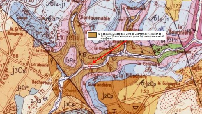
Le site du Puits d'enfer, entre Nanteuil et Exireuil, fait partie du graben de Saint Maixen l'Ecole.
Ce fossé d'effondrement est une vaste dépression d'environ 2,5 km de large où coule la Sèvre Niortaise et plusieurs de ses affluents.
Au sein de ce graben, le ruisseau du Puits d'Enfer a creusé un profond vallon d'environ 50 mètres de hauteur, et à mis à nu des formations géologiques très anciennes du Cambrien supérieur (il y a environ 500 millions d'années), des roches métamorphiques de type métagrauwackes et métapélites.
► Les méta-formations du Puits d'enfer
Ces méta-formations sont des roches métamorphiques, c'est à dire des roches secondaires issues d'un protolithe transformé sous l'influence de fortes pressions et températures.
~ Métagrauwackes
Il s'agit d'une roche métamorphique issue de la transformation de grauwackes, une formation sédimentaire généralement issue de l'érosion d'anciens volcans. On parle de roches volcano-sédimentaires.
Les métagrauwackes ont une granulométrie très variable : on passe constamment, plus ou moins brutalement, de termes gréseux grossiers à tendance microconglomératique à des grauwackes moyennes. Les grains restent cependant assez grossiers, avec des grains visibles à l'oeil nu.
Elles sont généralement de couleur verdâtre, du fait de la présence de chlorite, dans les conditions du faciès schistes verts.
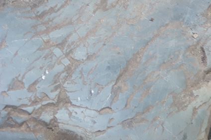
~ Métapélites
Cette roche métamorphique se différencie des métagrauwackes par l'origine des clastes et par la taille des éléments de la roche.
Cette formation provient de la transformation de pélites, des roches sédimentaires argileuses (argilites vertes ou bleues), qui sont au sens strict une classe de roches sédimentaires détritiques dont les éléments ont un diamètre inférieur à 1/16 mm (moins de 63 µm), donc invisibles à l'oeil nu.
Les métapélites sont donc une roche au grain très fin, de couleur bleue-vert, généralement homogène, mais parfois finement laminée. Elle présente une surface mate et sans reflet.
► Altération des formations métamorphiques
L'action des facteurs externes, et particulièrement l'eau d'origine météoritique, entraîne une altération de ces formations géologiques métamorphiques, donnant le relief tourmenté du Puits d'enfer.
Les phénomènes principaux d'altération par l'eau observables sur ces méta-formations sont :
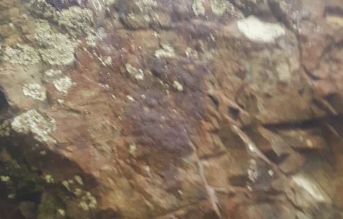
~ Les oxydations
Les oxydations concernent surtout le fer qui passe de l'état ferreux à l'état ferrique.
Elles sont particulièrement visibles dans les couches de métagrauwackes, donnant une coloration rouge voir rouille très prononcée à la roche.
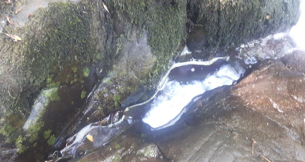
~ L'hydratation et L'hydrolyse
L'hydratation est l'incorporation de molécules d'eau à certains minéraux peu hydratés.
Elle produit un gonflement du minéral et donc favorise la destruction de la roche.
L'hydrolyse se définie comme étant la destruction d'un édifice moléculaire complexe en édifices moléculaires plus simples sous l'influence de l'eau.
Ces formes d'altération impactent principalement les métapélites.
Ces mécanismes sont activés par l'écoulement quasi permanente d'eau de pluie ou de ruissellements et la présence d'eau stagnante souvent chargée en débris végétaux donnant des acides humiques avec un pH très bas.
Cela aboutit sur les surfaces horizontales du bord du cours d'eau, à la mise en place de forme en creux, qu'on appelle des cupules.
► Local geological context
The site of the well of hell, between Nanteuil and Exireuil, is part of the graben of Saint Maixen l'Ecole. This collapse ditch is a vast depression of about 2.5 km wide where runs the Sèvre niortaise and several of its tributaries.
Within this graben, the Well of Hell Creek has dug a deep valley about 50 meters high, and exposed very ancient geological formations of the Upper Cambrian (about 500 million years ago) metamorphic rocks of the metagrauwackes and metapelites type.
► Meta-formations of the Well of Hell
These meta-formations are metamorphic rocks, ie secondary rocks from a protolith transformed under the influence of high pressures and temperatures.
~ Metagrauwackes
It is a metamorphic rock resulting from the transformation of grauwackes, a sedimentary formation generally resulting from the erosion of ancient volcanoes. We speak of volcano-sedimentary rocks.
The metagrauwackes have a very variable granulometry: one passes constantly, more or less brutally, from coarse sandstone terms with microconglomerate tendency to average grauwackes. The grains, however, remain rather coarse, with grains visible to the naked eye.
They are generally greenish in color due to the presence of chlorite under greenschist facies conditions.
~ Metapelites
This metamorphic rock differs from the metagrauwackes by the origin of the clasts and the size of the elements of the rock.
This formation comes from the transformation of pelites, clayey sedimentary rocks (green or blue argillites), which are in the strict sense a class of detrital sedimentary rocks whose elements have a diameter less than 1/16 mm (less than 63 μm), therefore invisible to the naked eye.
The metapelites are therefore a very fine-grained, blue-green rock, generally homogeneous, but sometimes finely rolled. It has a matt, non-reflective surface.
► Alteration of metamorphic formations
The action of external factors, especially meteoritic water, causes an alteration of these metamorphic geological formations, giving the tormented relief of the Well of Hell.
The main phenomena of alteration by water observable on these meta-formations are:
~ Oxidation
The oxidations mainly concern the iron which passes from the ferrous state to the ferric state.
They are particularly visible in the layers of metagrauwackes, giving a red color to see very pronounced rust in the rock.
~ Hydration and Hydrolysis
Hydration is the incorporation of water molecules to some poorly hydrated minerals.
It produces a swelling of the mineral and thus promotes the destruction of the rock.
Hydrolysis is defined as the destruction of a complex molecular edifice in simpler molecular edifices under the influence of water.
These forms of alteration primarily affect metapelites.
These mechanisms are activated by the almost permanent flow of rainwater or runoff and the presence of stagnant water often loaded with plant debris giving humic acids with a very low pH.
This results in the horizontal surfaces of the edge of the stream, the establishment of hollow form, called cups.
► Sources bibliographiques / Bibliographical sources
Les Questions / The Questions
La lecture attentive du descriptif de la cache, ainsi qu'une observation des éléments de terrain et un peu de déduction sont normalement suffisants pour répondre aux questions de cette EarthCache.
A careful reading of the description of the cache, as well as observation of terrain features and some deduction is usually sufficient to answer questions of this EarthCache.
Questions pour valider :"Méta-formations au Puits d'Enfer"
Questions to validate: "Meta-formations at the Well of Hell"
Nous voici au cœur du Puits d'enfer, après une zone plus escarpée donne sur un platier au bord du ruisseau du puits d'enfer.
Observons de plus près le début de ce platier (voir photo WP1_Zone_A_B en utilisant le repère de randonnée blanc et rouge pour repérer les zones à observer).
Here we are at the heart of the Well of Hell, after a steeper area overlooks a flatbed by the brook of the well of hell.
Let's take a closer look at the beginning of this flatbed (see photo WP1_Zone_A_B using the white and red hiking marker to identify areas to observe).
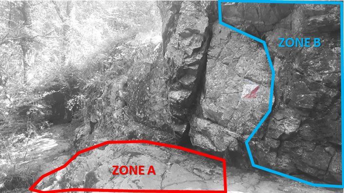
- Question 1 : Décrire la roche de la zone A (fin des "marches" et début du platier). A partir de vos observations, déterminer s'il s'agit de métapélites ou de métagrauwackes.
- Question 1 : Describe the rock in zone A (end of the "steps" and beginning of the plateaus). From your observations, determine whether it is metapelites or metagrauwackes.
- Question 2 : Observation la coloration de la zone B ; qu'est-ce qui en est à l'origine ?
- Question 2 : Observation staining of zone B; what is at the origin?
Avancer de quelques mètres sur le platier en longeant le ruisseau et repérer la zone jaune C (photo WP1_Zone_C).
Advance a few meters on the flat along the stream and locate the yellow area C (photo WP1_Zone_C).
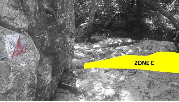
- Question 3 : Décrivez ce que vous voyez sous la zone C. Comme s'appelle cette formation et qu'est ce qui en est à l'origine ?
- Question 3 : Describe what you see under zone C. What is this training called and what is it?
Vous pouvez vous loguer sans attendre notre confirmation,
mais vous devez nous envoyer les réponses en même temps soit par mail via notre profil (
fafahakkai), soit via la messagerie geocaching.com (Message Center).
S'il y a des problèmes avec vos réponses nous vous en ferons part. Les logs enregistrés sans réponses seront supprimés.
Une photo de vous ou de votre GPS avec le cours du ruisseau du Puits d'enfer en arrière plan est la bienvenue, mais n'est pas obligatoire.
You can log this cache without waiting for our confirmation, but you must send us the answers at the same time, by e-mail via our profile (fafahakkai) or by the system of Message Center of geocaching.com.
If there is a problem with your answers we will notify you. The logs recorded without answers will be deleted.
A photo of you or your GPS with the course of the Well of Hell Creek in the background is welcome, but is not mandatory.
Rappel concernant les « Earthcaches »: Il n'y a pas de conteneur à rechercher ni de logbook à renseigner. Il suffit de se rendre sur les lieux, de répondre aux questions ci-dessus et de nous renvoyer les réponses.
Reminder concerning "Earthcaches": there is neither a container to look for nor a logbook to sign. One need only go to the location, answer to the differents questions and send us the answers.