
La Earthcache / The Earthcache
Parce qu'il n'y a pas que le grès vosgien en Alsace...
Cette petite série de caches géologiques a pour objectif de permettre la découverte sur le terrain de la richesse géologique du Centre Alsace et d'avoir un court aperçu de son histoire tumultueuse qui a aboutit à la mise en place de cette diversité de roches et des phénomènes tectoniques majeures dont cette région a été l'objet au travers des Ages.
Ce troisième épisode nous amène dans la colline abrupte du Letzenberg sur les traces des premiers témoins de la formation du Bassin Rhénan, l'un des plus beaux affleurements côtiers de bordure de rift visibles en France.
► Contexte géologique local
L'étude de la carte géologique du Letzenberg permet de distinguer une formation originale épousant parfaitement la forme de la colline.
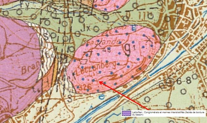
D'après la notice géologique, il s'agit d'une formation notée g1 du Lattorfien : Conglomérats et marnes interstratifiées (faciès de bordure du bassin) .
Largement représentée dans les champs de fractures, cette série est remarquable par son épaisseur, estimée à plusieurs centaines de mètres ; elle comprend de puissantes formations conglomératiques où s'intercalent des marnes rouges, brunes, vertes ou beiges.
► Mise en place de la formation oligocène
Cette formation détritique constituée principalement de conglomérats calcaires, plus rarement par des grès jaunes a été mise en place à la fin de l’Eocène il y a environ 35 million d’années.
Elle est le témoin le plus saillant des premières phases de la formation du fossé (rift) du Rhin.
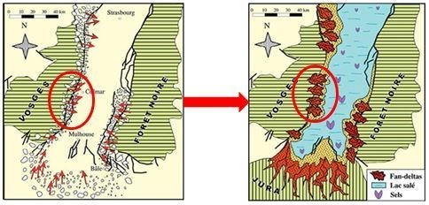
A l'Oligocène la convergence Nord-Sud induit la mise en place du rift Ouest-européen, dont le fossé rhénan fait partie.
Les terrains se trouvant sur les épaules du rift (Vosges et Forêt Noire) sont alors soumis à l'érosion.
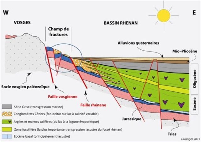
Les produits de leur démantèlement sont transportés dans des canyons dirigés vers le centre du fossé alors occupé par un lac. Au débouché de ces canyons les matériaux transportés sédimentent sous forme de vastes cônes alluviaux.
Cette sédimentation grossière remaniant les terrains des épaules du rift donne naissance aux conglomérats côtiers.
► Conglomérats cotiers et marnes oligocènes
~ Conglomérats côtiers
Ces conglomérats sont des roches sédimentaires détritiques et répondent au principe de la sédimentation inverse : les niveaux les plus récents contiennent les galets de matériel le plus ancien.
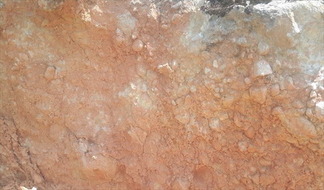
Ils sont constitués par un assemblage d'éléments plus ou moins arrondis, de taille variable (du millimètre au mètre), mal triés, comprenant toute la gamme des terrains sédimentaires anté-oligocènes.
Ce sont les calcaires oolitiques de la formation de la Grande oolite bajocienne qui dominent, avec plus de 70 % des matériaux.
Ce sont eux qui donnent la couleur dominante jaune à la formation.
Les galets peuvent être enrobés dans une matrice gréso-argileuse peu consolidée, ou être fortement liés par un ciment carbonaté.
Ce ciment peut présenter une coloration rouge-ocre en cas de forte présence de fer dans le ciment.
Ces amas de galets sont d'origine fluviatile.
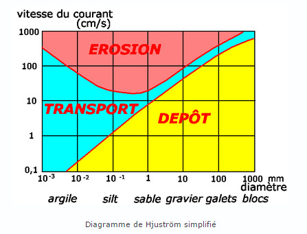
De ce fait, leur condition de dépôt dépend fortement de la vitesse du courant, comme le montre le diagramme de Hjuström qui permet de déterminer la nature du courant (torrentiel ou plus calme).
~ Marnes oligocènes
Les marnes interstratifiées dans les conglomérats sont d'origine différente.
Ce sont des marnes lacustres qui se sont formées par dépôts d'argile (boues) et de débris d'une microfaune liasique remaniée d'âge lattorfien, lors d'incursions marines plus ou moins franches pendant des périodes limitées.
La marne est une roche sédimentaire détritique caractérisée par une taille de grain très faible, inférieure au millimètre, de couleur claire (principalement gris-blanche). Ces sédiments se sont disposés en fines couches.
Because there is not only the Vosges sandstone in Alsace ...
This small series of geological caches is intended to allow the discovery on the ground of the geological wealth of the Alsace Center and to have a brief overview of its tumultuous history which has led to the establishment of this diversity of rocks and phenomena major tectonics of which this region has been the object through the Ages.
This third episode takes us to the steep Letzenberg hill in the footsteps of the first witnesses of the formation of the Rhine Basin, one of the most beautiful rift-edge coastal outcrops visible in France.
► Local geological context
The study of the geological map of Letzenberg makes it possible to distinguish an original formation perfectly marrying the shape of the hill.
According to the geological notice, it is a formation noted g1 of Lattorfien: Conglomerates and marl interstratified (facies of border of the basin).
Widely represented in fracture fields, this series is remarkable for its thickness, estimated at several hundred meters; it includes powerful conglomeratic formations with red, brown, green or beige marls.
► Establishment of the Oligocene Formation
This detrital formation consisting mainly of calcareous conglomerates, and more rarely by yellow sandstone was established at the end of the Eocene about 35 million years ago.
It is the most prominent witness of the early stages of the formation of the Rhine Rift.
At the Oligocene the North-South convergence induces the establishment of the West-European rift, of which the Rhine ditch is part.
The lands on the shoulders of the rift (Vosges and Black Forest) are then subject to erosion.
The products of their dismantling are transported in canyons directed towards the center of the ditch then occupied by a lake. At the outlet of these canyons the transported materials sediment in the form of large alluvial cones.
This coarse sedimentation reshaping the lands of the rift shoulders gives rise to coastal conglomerates.
► Coastal Conglomerates and Oligocene Marls
~ Coastal agglomerations
These conglomerates are detrital sedimentary rocks and respond to the principle of reverse sedimentation: the most recent levels contain the oldest material pebbles.
They are constituted by an assembly of more or less rounded elements, of variable size (from the millimeter to the meter), poorly sorted, including all the range of the pre-Oligocene sedimentary grounds.
It is the oolitic limestones of the formation of the Bajocian Great Oolite that dominate, with more than 70% of the materials.
It is they who give the dominant yellow color to the formation.
The pebbles may be embedded in a weakly consolidated clay-silty matrix, or may be strongly bonded by a carbonate cement.
This cement may present a red-ocher color in case of strong presence of iron in the cement.
These piles of pebbles are of fluviatile origin.
As a result, their deposition condition strongly depends on the velocity of the current, as shown in the Hjuström diagram which makes it possible to determine the nature of the current (torrential or quieter).
~ Oligocene marl
The marl interbedded in the conglomerates are of different origin.
They are lacustrine marls formed by deposits of clay (sludge) and debris of a remastered liasic microfauna of lattorfian age, during marine incursions more or less free during limited periods.
Marl is a detrital sedimentary rock characterized by a very small grain size, less than a millimeter, of light color (mainly gray-white). These sediments are arranged in thin layers.
► Sources bibliographiques / Bibliographical sources
Les Questions / The Questions
La lecture attentive du descriptif de la cache, ainsi qu'une observation des éléments de terrain et un peu de déduction sont normalement suffisants pour répondre aux questions de cette EarthCache.
A careful reading of the description of the cache, as well as observation of terrain features and some deduction is usually sufficient to answer questions of this EarthCache.
Questions pour valider :"Conglomérats et Marnes au Letzenberg"
Questions to validate: "Conglomerates and Marls at Letzenberg"
Point 1 : N 48° 05.505 E 007° 17.267
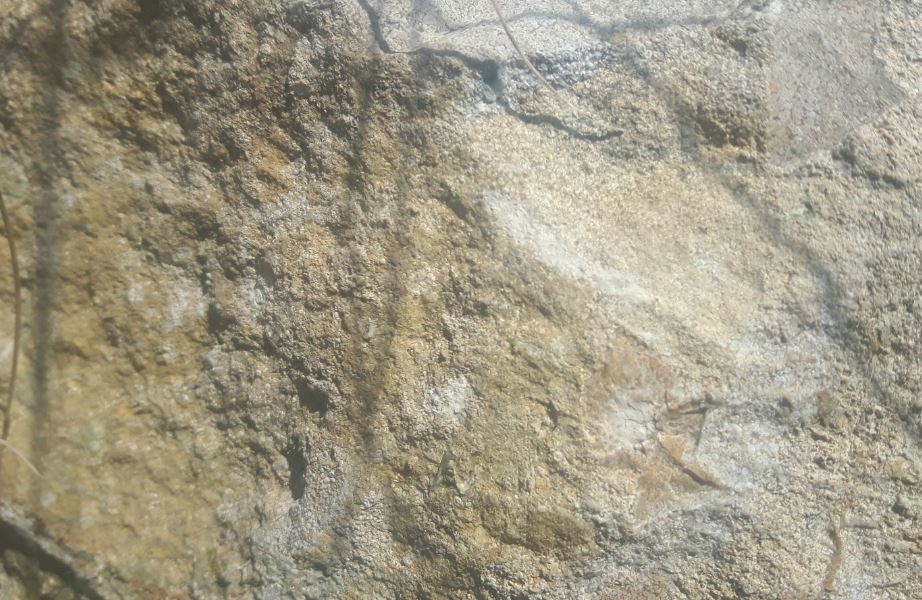
Vous voici devant un premier affleurement, à droite du chemin quand on monte depuis le parking (photo WP1).
Here you are in front of a first outcrop, to the right of the path when you come up from the car park, photo WP1.
- Question 1 : Décrire la roche de cet affleurement sous la zone rouge (couleur, taille des grains, homogénéité des éléments formant la roche). Quelle est la nature de cette formation ?
- Question 1 : Describe the rock of this outcrop under the red zone (color, grain size, homogeneity of the elements forming the rock). What is the nature of this formation?
Point 2 : N 48°05.498' E 007°17.276'

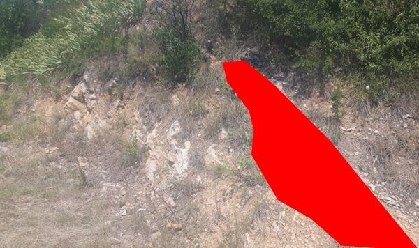
Vous voici devant un second affleurement très coloré, à gauche du chemin quand vous venez du WP1 (ou à droite quand on monte depuis le parking), voir photo WP2.
Here you are in front of a second very colorful outcrop, to the left of the path when you come from the WP1 (or to the right when you come up from the car park), photo WP2.
- Question 2 : Décrire la roche de cet affleurement sous l'avant de la zone bleue (couleur, taille des éléments détritiques, présence d'une matrice, homogénéité des éléments formant la roche). Quelle est la nature de cette formation ?
- Question 2 : Describe the rock of this outcrop of the blue zone (color, size of the detrital elements, presence of a matrix, homogeneity of the elements forming the rock). What is the nature of this formation?
- Question 3 : Quelle couleur très vive présente cette formation ? Qu'est ce qui en est à l'origine ?
- Question 3 : What very bright color overall this formation? What is at the origin?
Point 3 : N 48°05.479' E 007°17.308'
En suivant le chemin, vous arrivez devant une grotte, présentant une ancienne carrière à flan de colline.
Following the path, you arrive in front of a cave, presenting an old quarry on a hillside.
- Question 4 : Depuis le chemin, estimer la taille des plus gros blocs constituant la formation rocheuse. Quelle forme ont ces éléments ?
A partir de ces informations, déduisez en leur condition de dépôt (régime du courant).
- Question 4 : From the path, estimate the size of the largest blocks making up the rock formation. What form do these elements have?
From this information, deduce in their deposit condition.
Vous pouvez vous loguer sans attendre notre confirmation,
mais vous devez nous envoyer les réponses en même temps soit par mail via notre profil (
fafahakkai), soit via la messagerie geocaching.com (Message Center).
S'il y a des problèmes avec vos réponses nous vous en ferons part.
Les logs enregistrés sans réponses seront supprimés.Une photo de vous ou de votre GPS depuis le parking avec la colline du Letzenberg et sa carrière en arrière plan est la bienvenue, mais n'est pas obligatoire.
You can log this cache without waiting for our confirmation, but you must send us the answers at the same time, by e-mail via our profile (fafahakkai) or by the system of Message Center of geocaching.com.
If there is a problem with your answers we will notify you. The logs recorded without answers will be deleted.
A photo of you or your GPS from the parking lot with the Letzenberg hill and its career in the background is welcome, but not mandatory.
Rappel concernant les « Earthcaches »: Il n'y a pas de conteneur à rechercher ni de logbook à renseigner. Il suffit de se rendre sur les lieux, de répondre aux questions ci-dessus et de nous renvoyer les réponses.
Reminder concerning "Earthcaches": there is neither a container to look for nor a logbook to sign. One need only go to the location, answer to the differents questions and send us the answers.