La colline de Lauw-Sentheim est exceptionnelle, car s'y trouvent réunis sur moins d'1 km², des terrains d'âge primaire, secondaire, tertiaire et quaternaire, qui nous permettent de traverser 350 millions d'années d'histoire géologique de la création du massif des Vosges en seulement 3 heures de marche !
Etapes de création du massif des Vosges
-1 milliard d'années
Cette époque est encore mal connue. Il aurait peut être existé un océan avec de la vase et du sable. Des éruptions volcaniques ont lieu sur la région.
-310 à -295 millions d'années (Carbonifère)
La chaîne de montagne hercynienne se forme de l'Angleterre à la Hongrie. Elle est constituée de granite.
-295 à -240 millions d'années (Permien)
Le climat est chaud et aride. L'érosion importante va entièrement démanteler la chaîne hercynienne. Le paysage ressemble à un désert de sable avec des dunes. Ce sable constituera plus tard le grès.
-240 à -205 millions d'années (Trias)
La partie Est s'effondre et devient la Mer Germanique vers laquelle afflue des fleuves provenant de la région parisienne. Du sable et des galets sont alors charriés par des fleuves et torrents. Le sable fin formera le grès Vosgien, le mélange avec les galets le conglomérat et le sable mélangé à de l'argile le grès à Voltzia.
-205 à -135 millions d'années (Jurassique)
La mer recouvre maintenant toute la région. Des dépôts sédimentaires coquilliers s'effectuent au fond de la mer qui donneront le calcaire.
-135 à –46 millions d'années (Crétacé)
La mer se retire. L'érosion commence.
-46 à -23 millions d'années (Eocène Oligocène)
Les Vosges se distendent et le fossé rhénan s'affaisse en même temps. Les Alpes se soulèvent et par contre coup les Vosges et la Forêt Noire aussi mais plus au Sud qu'au Nord.
-23 à maintenant
L'érosion est importante grâce à des climats froids et arides qui se succèdent. Le granite
hercynien affleure sur les Hautes Vosges.
Aux coordonnées de la cache vous pourrez observer une partie d’un pli géologique.
Un pli peu être défini par les charactéristiques suivantes :
Une surface plane courbée admet localement un arc de cercle pour description. L'inverse de ce rayon est nommé ici courbure de la surface. Plus cette surface est proche d'un plan, plus sa courbure est faible et plus le rayon du cercle associé est grand. Cette définition correspond à la notion de courbure. Ainsi la courbure de la terre est plus faible que la courbure de n'importe quel pli observable.
La région du pli où la courbure est maximale est la charnière du pli. La crête du pli désigne le point topographique le plus élevé du pli. Les régions de courbure minimale, situées de part et d'autre de la charnière sont les flancs du pli. Dans le cas d'un pli dans une roche sédimentaire, les charnières de chaque couche définissent un axe du pli sur une coupe. En volume, ces axes définissent un plan axial du pli. Dans un pli, le sens de la courbure est donné par la direction de sa convexité. Ainsi, une Antiforme a sa convexité vers le haut et une Synforme a sa convexité vers le bas. Les expressions anticlinal et synclinal désignent des antiformes et des synformes dans des roches dont on connait l'âge relatif des couches.
La terminaison d'un pli de type antiforme ou anticlinal se nomme terminaison périclinale. La terminaison d'un pli synforme ou synclinal se nomme terminaison périsynclinale.
Un pli anticlinal présente les couches les plus anciennes au cœur du pli, tandis qu'un pli synclinal présente les couches les plus récentes en son centre.

Les plis peuvent avoir différentes allures comme le montre les schémas ci dessous.
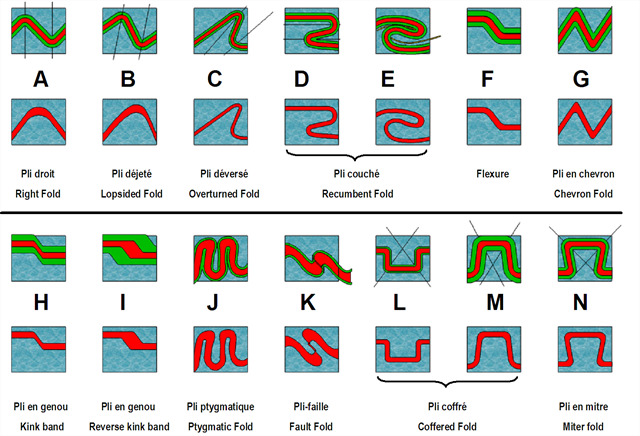
Pour valider cette earthcache rendez vous aux coordonnées, observez et répondez aux questions suivantes :
- Parmi les différents types de plis présentés plus haut lequel se rapproche de ce que vous observez.
- Voyez vous la charnière du pli ? Ce pli de fait est il antiforme ou synforme ?
- A l’aide des étapes de la création du massif des Vosges (voir plus haut) pouvez vous dater la formation du pli.
Loguez cette cache "Found it" et envoyez-moi vos propositions de réponses soit via mon profil, soit via la messagerie geocaching.com (Message Center), et je vous contacterai en cas de problème.
Pleated limestone of the Bajocian
The Lauw-Sentheim hill is exceptional, because there are gathered on less than 1 km ², primary, secondary, tertiary and quaternary, which allow us to cross 350 million years of geological history of the creation of the Vosges mountains in just 3 hours of walking!
Stages of creation of the Vosges massif
-1 billion years
This time is still poorly known. It might have been an ocean with mud and sand. Volcanic eruptions occur in the area.
-310 to -295 million years ago (Carboniferous)
The Hercynian mountain range is formed from England to Hungary. It is made of granite.
-295 to -240 million years ago (Permian)
The climate is hot and arid. The significant erosion will completely dismantle the Hercynian chain. The landscape looks like a sand desert with dunes. This sand will later be sandstone.
-240 to -205 million years ago (Trias)
The eastern part collapses and becomes the Germanic Sea to which flows rivers from the Paris region. Sand and pebbles are then carried by rivers and torrents. The fine sand will form the Vosges sandstone, the mixture with the pebbles the conglomerate and sand mixed with sandstone clay in Voltzia.
-205 to -135 million years ago (Jurassic)
The sea now covers the whole region. Sedimentary sedimentary deposits are carried out at the bottom of the sea which will give the limestone.
-135 to -46 million years ago (Cretaceous)
The sea is withdrawing. Erosion begins.
-46 to -23 million years (Eocene Oligocene)
The Vosges distend and the Rhine ditch collapses at the same time. The Alps rise up and the Vosges and the Black Forest, but more to the South than to the North.
-23 to now
Erosion is important because of the cold and arid climates that follow each other. Granite
Hercynian outcrops on the High Vosges.
At the coordinates of the cache you can observe part of a geological fold.
A fold can be defined by the following characteristics:
A curved flat surface locally admits a circular arc for description. The inverse of this ray is here named curvature of the surface. The closer this surface is to a plane, the lower its curvature and the greater the radius of the associated circle. This definition corresponds to the notion of curvature. Thus the curvature of the earth is weaker than the curvature of any observable fold.
The area of the fold where the curvature is maximum is the hinge of the fold. The crest of the fold designates the topographic point of the fold. The regions of minimum curvature, located on both sides of the hinge are the flanks of the fold. In the case of a fold in a sedimentary rock, the hinges of each layer define an axis of the fold on a section. In volume, these axes define an axial plane of the fold. In a fold, the direction of the curvature is given by the direction of its convexity. Thus, an Antiform has its convexity upwards and a Synform has its convexity downwards. The anticlinal and synclinal expressions denote antiforms and synforms in rocks whose relative ages are known.
The termination of an antiform or anticlinal type fold is called a periclinal termination. The termination of a synformal or synclinal fold is called a perisynclinal termination.
An anticlinal fold presents the oldest layers at the heart of the fold, while a synclinal fold presents the most recent layers in its center.
The folds can have different speeds as shown in the diagrams below.
To validate this earthcache go to the coordinates, observe and answer the following questions:
- Among the different types of folds presented above which is close to what you observe.
- Do you see the hinge of the fold? This fold of fact is it antiform or synform?
- Using the steps of the creation of the Vosges massif (see above) can you date the formation of the fold.
Log this cache "Found it" and send me your suggestions for answers either through my profile or via the messaging geocaching.com (Message Center), and I will contact you in case of problems.