
Géologie d'oued Ziz - résumé français via translator (Sorry, I can't speak french)
Le Maroc est l'une des terres les plus fascinantes au monde pour l'étude de la géologie. La plupart du Maroc La Méditerranée beingsituated Dans ces zones climatiques sub-saharienne, avec une moyenne n-Nual Précipitations Allant de 300 à 600 mm, il offre des paysages larges, avec des roches sous-surface exposée dans les affleurements splendides. Last but not least, le Maroc est situé à une triple jonction entre continent et (Afrique), un océan (l'Atlantique) et une zone de collision de plaque active (système de ceinture alpin). Il en résulte une ruggedtopography d'un grand choix de affleurantes archéennes terranes couvrant d'un Cenozoic l'âge, ainsi que des systèmes tectoniques différents de bassins sédimentaires tometamorphic plier la ceinture. Les minéraux et les fossiles du Maroc sont conservés dans les musées du monde entier. Enfin, il convient de souligner que les ressources naturelles extraites du sous-sol marocain sont importantes pour l'économie nationale (phosphate, Ag, Pb, Zn, barytine, fl uorspar, etc.). À l'heure actuelle, il existe également une exploration offshore active pour le pétrole et le gaz.
La rivière Ziz jaillit près de Rich City et mène au bord du Sahara, à travers Merzouga, et Touz jusqu'à disparaître quelque part dans le désert. 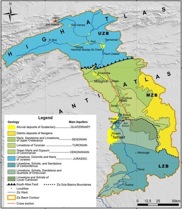 Oued Ziz Dans les temps anciens, la vallée était un passage pour les caravanes de l'Afrique subsaharienne vers la mer Méditerranée. Le tunnel du Légionnaire, construit pendant la colonisation française en 1930, créa un passage des montagnes à la vallée de Ziz. Ensuite, la rivière descend de la plate-forme vers le canyon et environ 80 km ne sont que des palmiers. La route est bordée par les villages, et quand on regarde la route, on a l’impression que c’est une rivière de palmiers, pas une rivière avec de l’eau. En face d'Erfoud, il y a une plate-forme qui mène à l'oasis, qui continue jusqu'à Rissani, où le désert commence déjà. Ziz Valley a beaucoup de palmiers et est probablement le plus important des oasis marocaines dans la région de Tafilalt qui est en fait un énorme Palm Grove baignées par l'eau de l'IRS. Il dit que l'eau de la rivière Ziz favorise la fertilité des femmes ... Oued Ziz Dans les temps anciens, la vallée était un passage pour les caravanes de l'Afrique subsaharienne vers la mer Méditerranée. Le tunnel du Légionnaire, construit pendant la colonisation française en 1930, créa un passage des montagnes à la vallée de Ziz. Ensuite, la rivière descend de la plate-forme vers le canyon et environ 80 km ne sont que des palmiers. La route est bordée par les villages, et quand on regarde la route, on a l’impression que c’est une rivière de palmiers, pas une rivière avec de l’eau. En face d'Erfoud, il y a une plate-forme qui mène à l'oasis, qui continue jusqu'à Rissani, où le désert commence déjà. Ziz Valley a beaucoup de palmiers et est probablement le plus important des oasis marocaines dans la région de Tafilalt qui est en fait un énorme Palm Grove baignées par l'eau de l'IRS. Il dit que l'eau de la rivière Ziz favorise la fertilité des femmes ...
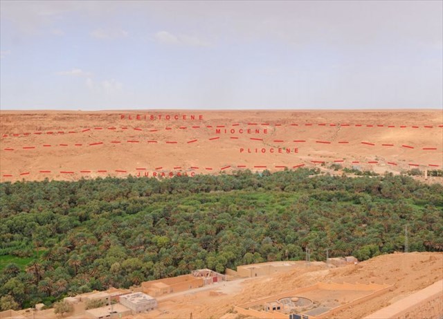
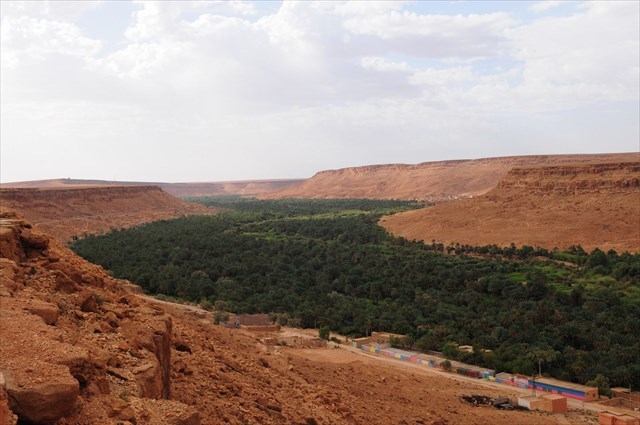
La vallée entière de la rivière Ziz est l'une des plus grandes oasis du Maroc. D'après les vues ci-dessus, il ressemble à un énorme serpent vert de palmiers dataux dans une campagne par ailleurs totalement aride. Les plus belles vues de la vallée de Ziz sont justes de ce point de vue. Sauf le serpent vert des palmiers, vous pouvez voir le profil profond typique du stockage de la roche. Ceci est typique pour ce que l'on appelle la "superposition" (les roches plus anciennes sont plus profondes et les plus jeunes sont en haut). Ces roches étaient principalement formées pendant le mésozoïque (jurassique) - les parties inférieures, tertiaires (paélogène, néogène) et quaternaires (pléistocène) - les parties supérieures.
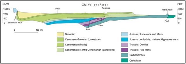
La vallée de Ziz est juste au bord du Haut Atlas et de l'Anti-Atlas et c'est pourquoi, à l'aigle des roches de calcaire et de grès. La vallée et toute la région de la rivière Ziz souffrent d'une grande érosion. La matière des parties supérieures de la rivière est acheminée vers les parties inférieures et le processus de sédimentation se produit.
Tout en haut, il y a des plaines droites typiques sans autres élévations, mais certaines formations rocheuses intéressantes peuvent parfois apparaître ici. Dans certaines parties, il y a plusieurs rochers caractéristiques ressemblant à des champignons, créés par l'altération du vent.
Il existe peu de sources sur la géologie marocaine et la géologie de la rivière Ziz. Si vous avez des informations intéressantes sur Ziz River, s'il vous plaît contactez-moi, je l'ajouterai à la liste.
Resources:
internet
---------------------------------------------------------------------------------------------------------------------------------------------
Your tasks are:
1) Aux coordonnées initiales, estimez la largeur du canyon et estimez la profondeur du canyon au même endroit. Essayez de calculer combien de matériau en mètres cubes, la rivière a dû enlever sur ses 100 mètres de long. Essayez de convertir en tonalités. Pour cette tâche, considérez que les parois du canyon sont verticales et non inclinées. Cette tâche est une simple quête de la géométrie de l'école primaire.
2) Ecrivez-moi les noms de 3 autres canyons similaires dans le monde.
3) Quelle est l'altitude sur votre GPS?
4) Tâche facultative - Veuillez joindre des photos de vous ou de votre GPS à la vallée.
Your Les bonnes réponses m'envoient via mon centre de messagerie ou par e-mail via mon profil, que vous pouvez enregistrer votre visite. Si vos réponses ne sont pas correctes, je vous donnerai un écho. S'il vous plaît respecter une règle - 1 log = 1 email avec les réponses. Dans ce cas, je vais être intransigeant, qui se connectera sans envoyer de réponses, il sera supprimé. C'est une preuve pour moi que tu étais là et que tu fais quelque chose pour un point.
|