Geologists classify a Breccia as a rock composed of broken fragments of minerals or rock cemented together by a fine-grained matrix that can be similar to or different from the composition of the fragments. The word has its origins in the Italian language, in which it means either "loose gravel" or "stone made by cemented gravel". A breccia may have a variety of different origins, as indicated by the named types including sedimentary breccia, tectonic breccia, igneous breccia, impact breccia, and hydrothermal breccia.
Sedimentary breccia - is a type of clastic sedimentary rock, which is made of angular to subangular, randomly oriented clasts of other sedimentary rocks.
Fault or tectonic breccia - results from the grinding action of two fault blocks as they slide past each other. Subsequent cementation of these broken fragments may occur by means of the introduction of mineral matter in groundwater.
Igneous clastic breccia can be divided into two classes – 1. Broken, fragmental rocks associated with volcanic eruptions, both of the lava and pyroclastic type; 2. Broken, fragmental rocks produced by intrusive processes, usually associated with plutons or porphyry stocks.
Impact breccias - are thought to be diagnostic of an impact event such as an asteroid or comet striking the Earth and are normally found at impact craters. Impact breccia, a type of impactite, forms during the process of impact cratering when large meteorites or comets impact with the Earth or other rocky planets or asteroids. Breccia of this type may be present on or beneath the floor of the crater, in the rim, or in the ejecta expelled beyond the crater.
Hydrothermal breccias - usually form at shallow crustal levels (<1 km) between 150 and 350 °C, when seismic or volcanic activity causes a void to open along a fault deep underground. The void draws in hot water, and as pressure in the cavity drops, the water violently boils. In addition, the sudden opening of a cavity causes rock at the sides of the fault to destabilise and implode inwards, and the broken rock gets caught up in a churning mixture of rock, steam and boiling water. Rock fragments collide with each other and the sides of the void, and the angular fragments become more rounded.
The EarthCache:
Look at the breccia in front of you and answer the following questions. Send me your answers via my profile.
- Based on the types of breccias above, which do you think fits the description best? Sedimentary, tectonic, igneous, impact or hydrothermal)
- What is the range in fragment size?
- What colour are the fragments? (are they yellow, bluish, or grey – You are excused from this one if you are colour blind)
- Look at the internal structure of the fragments. Are they homogeneous? Not homogeneous? Describe them.
Geomorphological setting
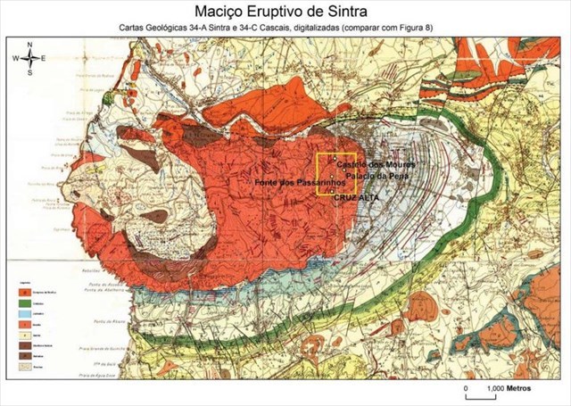
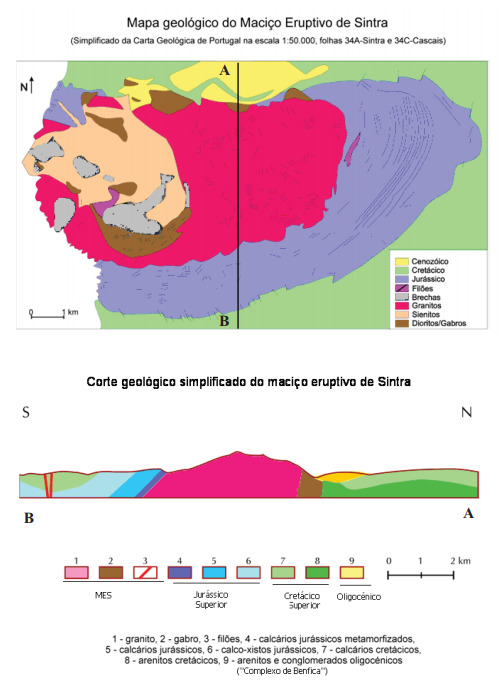
The Sintra Eruptive Massif (SEM) represents a small intrusive body of igneous rocks today exposed thanks to the combined work of alteration / erosion that over many millions of years first removed the initial sedimentary cover and later with the exposure of the igneous body produced (and still produces) the profile that is characteristic of it, a sharp edge, rising in the landscape whatever the point of approach to the Sintra Mountain. "Here where the Earth ends and the sea begins ..." (Luís de Camões, Os Lusíadas, canto III, stanza 20) we can apply this to the most western point of continental Europe, Cabo da Roca, an integral part of the massif that forms elliptical (5 per 10 km) and extends under the sea (-100m), with a maximum height of 529m at Cruz Alta.
The spectacularity of the relief results from the E-W orientation of the massif, its place of insertion, the coast, and the nature of the igneous rocks that compose it, which, however resistant to weathering processes (harder rocks), provide the magnificent profile seen today. Also spectacular is the chaos of blocks observed in particular in the area corresponding to the granites, which results from the conjugation of a previous lattice (consequence of a dense network of fractures that cuts the massif) with the continuous action of alteration / erosion processes.
Geological setting
The Sintra Eruptive Massif (SEM) is installed by cutting a dome structure formed by layers of sedimentary rocks (limestones and sandstones), of the Upper Jurassic and early Cretaceous. The igneous intrusion not only metamorphoses these country rocks; originating a narrow halo of metamorphic rocks, but also strongly deforms the sedimentary layers. In fact, in the north contact of the massif (Praia Grande do Rodízio) the sedimentary layers are vertical or almost so, while in the south, in the Guincho area, they dip south at about 45º.
The sedimentary formations up to the beginning of the Upper Cretaceous are deformed by the intrusion, which constrains the installation of the SEM until the end of the Cretaceous (approx. 66 M.a.). The radiometric ages obtained for different rocks of the massif established an interval of ages between 80 and 75 million years confirming the installation of the massif in the Upper Cretaceous.
Eruptive breccias
The significant expression of these type of outcrops are in Peninha-Monge, Moínho da Atalaia, Azóia, Rebolões and Camarinheira. These rocks are closely associated with the intrusion mechanisms of the various lithologies that make up the SEM, are located mainly in the interior and the periphery of the syenitic nucleus, except for the outcrops of the Camarinheiras inside the granites. The breccias are polygenic rocks composed of fragments representative of the various lithologies of the massif, from granular rocks to veins, where elements belonging to the metamorphic host can also be observed. The whole set is aggregated by an intermediate to mafic cement of igneous nature.
O que é?
Brecha é uma rocha clástica formada de fragmentos grandes e angulosos, em meio de uma massa de cimentação composta de material mais fino. Pode ter origem ígnea, sedimentar ou metamórfica.
Brecha sedimentar - é um tipo de rocha sedimentar clástica, que é feita de clastos de outras rochas sedimentares de formas angulares a sub-angulares, aleatoriamente orientados.
(Falha ou) brecha tectónica - resulta da ação de moagem de dois blocos de falha à medida que passam um pelo outro. A subsequente cimentação desses fragmentos quebrados pode ocorrer por meio da introdução de matéria mineral na água subterrânea.
A brecha clástica ígnea pode ser dividida em duas classes - 1. Rochas quebradas e fragmentadas associadas a erupções vulcânicas, ambas do tipo lava e piroclástica; 2. Rochas quebradas e fragmentadas produzidas por processos intrusivos, geralmente associadas a plutões ou rochas porfiríticas.
Brechas de impacto - acredita-se que sejam diagnósticas de um evento de impacto como um asteróide ou cometa atingindo a Terra e são normalmente encontradas em crateras de impacto. A brecha de impacto, um tipo de impactita, se forma durante o processo de colisão de impacto quando grandes meteoritos ou cometas impactam com a Terra ou outros planetas rochosos ou asteróides. Brechas deste tipo podem estar presentes no solo ou abaixo dele, na borda ou na ejeção expelida para além da cratera.
Brechas hidrotermais - geralmente se formam em níveis rasos da crosta (<1 km) entre 150 e 350 ° C, quando a atividade sísmica ou vulcânica faz com que um vazio se abra ao longo de uma falha no subsolo. O vazio atrai a água quente e, quando a pressão na cavidade cai, a água ferve violentamente. Além disso, a abertura repentina de uma cavidade faz com que a rocha nos lados da falha desestabilize e imploda para dentro, e a rocha quebrada é pega em uma mistura agitada de rocha, vapor e água fervente. Fragmentos de rocha colidem entre si e com os lados do vazio, e os fragmentos angulares se tornam mais arredondados.
A EarthCache:
- Olha para a brecha à tua frente e responde às seguintes perguntas. Envia-me as respostas para AQUI para validar o teu registo:
- Com base nos tipos de brechas acima, qual se encaixa melhor na descrição? Sedimentar, tectónica, ígnea, impacto ou hidrotermal)
- Qual é a gama de tamanhos dos fragmentos?
- Quais são as cores predominantes dos fragmentos? (eles são amarelos, azulados ou cinza?
- Olhe para a estrutura interna dos fragmentos. Eles são homogéneos? Não são homogéneos? Descreve-os.
Enquadramento geomorfológico
O Maciço Eruptivo de Sintra (MES) representa um pequeno corpo intrusivo de rochas ígneas hoje exposto à observação graças ao trabalho conjugado da alteração/erosão que ao longo de muitos milhões de anos retirou primeiro a cobertura sedimentar inicial e posteriormente com a exposição do corpo ígneo produziu (e ainda produz) o perfil que lhe é característico, um gume afiado, elevando-se na paisagem qualquer que seja o ponto de aproximação à Serra de Sintra. “Aqui onde a Terra se acaba e o mar começa...” (Luís de Camões, Os Lusíadas, canto III, estrofe 20) podemos aplicar ao ponto mais ocidental da Europa, o Cabo da Roca, parte integrante do maciço que apresentando forma elíptica (5 por 10 km) e se prolonga sob a mar (-100m), tendo cota máxima a 529 m na Cruz Alta.
A espectacularidade do relevo resulta da orientação E-W do maciço, do seu local de inserção, no litoral, e da natureza das rochas ígneas que o compõem que, por mais resistentes aos processos de desgaste (rochas mais duras), proporcionam o magnifico perfil. Também espectacular é o caos de blocos que se observa, em particular, na área correspondente aos granitos, que resulta da conjugação de um reticulado prévio (consequência de densa rede de fracturas que corta o maciço) com a acção continuada de processos de alteração/erosão. (Fonte: AQUI)
Enquadramento Geológico
O Maciço Eruptivo de Sintra (MES) instala-se cortando uma estrutura em abóbada formada por camadas de rochas sedimentares de calcários margosos, calcários e arenitos do Jurássico Superior e início do Cretácico Superior. A intrusão ígnea não só metamorfiza, originando uma estreita auréola de rochas metamórficas, como deforma fortemente as camadas sedimentares encaixantes. De facto, no contacto norte do maciço (Praia Grande do Rodízio) as camadas sedimentares estão erguidas, próximo da vertical, enquanto a sul se encontram pouco inclinadas.
As formações sedimentares até ao início do Cretácico Superior são deformadas pela intrusão o que constrange a instalação do MES até ao fim do Cretácico. As idades radiométricas obtidas para diferentes rochas do maciço estabeleceram um intervalo de idades entre os 80 e os 75 milhões de anos confirmando a instalação do maciço no Cretácico Superior.
As Brechas eruptivas
A expressão significativa deste tipo de afloramentos são exemplo Peninha-Monge, Moínho da Atalaia, Azóia, Rebolões e Camarinheira. Estas rochas estão intimamente associadas aos mecanismos de intrusão das várias litologias que compõem o MES, situam-se principalmente no interior e na periferia do núcleo sienítico com excepção do afloramento das Camarinheiras no interior dos granitos. As brechas são rochas poligénicas contituídas por fragmentos representativos das várias litologias do maciço, desde rochas granulares a filões, onde se observam também elementos pertencentes ao encaixante metamórfico. Todo o conjunto é agregado por um cimento de natureza ígnea, intermédio a máfico. (Fonte: AQUI)