***Click or scroll down for the English version***
Geocache ‘de Pijp in de 20e eeuw’
Wat is het?
Deze Multicache van circa 5,5 km laat je de historische ontwikkeling van de Pijp zien. Je zou er denk ik een halve dag voor uit kunnen trekken, zeker wanneer je en passant de drie traditional caches wilt scoren, waar je onderweg zo’n beetje langskomt en nog een hapje gaat eten op één van de vele terrassen. De ervaring heeft geleerd dat de snellere Geocachers er op de scooter of fiets anderhalf uur over doen. Onderweg verzamel je gegevens waarmee je vanaf het eindpunt op zoek gaat naar de cache. Eenmaal moet je hiervoor iets opzoeken op internet. De cache container is groot genoeg om een kleine trackable in te stoppen.
Super korte inleiding
In het jaar 1874 werd in het noordwesten van de wijk de eerste steen gelegd, waar de route begint. Vóór dat jaar was hier slechts een polderlandschap waar koeien graasden en waar windmolens hout verzaagden langs de in het landschap gegraven afwateringssloten. Deze polder heette de ‘Binnendijkse Buitenveldertse polder’ en was rond 1630 drooggelegd. Tot die tijd, was dit, net als het hele gebied rondom de Amstel en zelfs een groot deel van west-Nederland een drassig landschap bestaande uit veenmoerassen. Wel al stonden er fantastische buitenhuizen langs de Amstel, die als tweede woning voor de rijke Amsterdammer dienden, en wat boerderijen in de toenmalige wijk ‘Meerhuizen’.
Meerhuizen was een wijk die oorspronkelijk viel binnen de gemeente ‘Nieuwer-Amstel’, dat weer bestuurd werd door Ouderkerk aan de Amstel. Ouderkerk aan de Amstel op haar beurt, was de eerste nederzetting van aanzien, en bestuurde het gehele gebied inclusief Amsterdam, voordat onze hoofdstad machtig genoeg was om de touwtjes zelf in handen te nemen. De gemeente Nieuwer-Amstel is in de loop der tijd gereduceerd tot het huidige Amstelveen. Even een paar jaartallen; de oudste vermelding van Amsterdam is in een document uit 1275 gevonden, maar opgravingen tijdens de Noord-Zuid lijn hebben het ontstaan van Amsterdam met honderd jaar vervroegd. Ouderkerk aan de Amstel zou zo’n honderd- tot tweehonderd jaar eerder dan Amsterdam al hebben bestaan.
Vraag je je af waar die mensen überhaupt vandaan kwamen? De eerste kolonisten kwamen o.a. vanuit de regio Utrecht, dat op een natuurlijke wijze veel hoger ligt op stevige zandgronden. Dit heeft alles te maken met ‘de Grote Ontginning’; Google hier maar eens op. Een typisch Nederlands fenomeen waarmee het ondoordringbare, laag gelegen veenmoeras in het westelijk deel van Nederland langzaam maar zeker gecultiveerd werd. Een proces dat rechtstreeks terug te zien is in het stratenpatroon van de Pijp dat je zo gaat ontdekken...
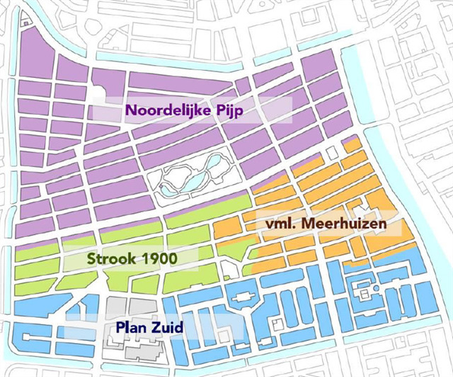
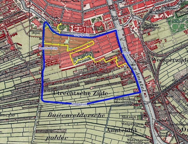
Vanaf 1874 is de Pijp in vier fases bebouwd geraakt, waar je gedurende de Geocache doorheen loopt. Iedere periode kent een eigen architect, visie en bouwstijl. De eerste woningen in het Noordwesten waren nog relatief grote woningen. De toenmalige architect had grootse plannen met de Pijp; op de plek waar nu in het midden het Sarphatipark is, had het centraal station van Amsterdam moeten komen! De straten in deze uiterste hoek lopen van noord naar zuid (zie kaartje), haaks op de bestaande afwateringssloten en looppaden binnen de oorspronkelijke polder.
Al snel bleek dit plan een onhaalbare kaart; bovendien waren er eenvoudigweg zo snel mogelijk heel veel nieuwe woningen nodig omdat het Amsterdam van binnen de Stadhouderskade (de laatste grachtengordel) uit haar voegen barste en continue te kampen had met epidemieën. Naast scheurbuik en syfilis heerste er onder andere pokken, dysenterie, griep, tyfus, tuberculose en cholera, in de volksmond ‘de blauwe dood’ genoemd. Daarom werd de rest van de Noordelijke Pijp snel volgebouwd met goedkope arbeiderswoningen, waar ook veel studenten en kunstenaars een kamer huurden. Straten volgen hier de oorspronkelijke afwateringssloten; dat was een stuk makkelijker te organiseren. Dichters en schrijvers hebben de treurige huisvesting uitgebreid beschreven, waar tegenover de gezellige reuring van het straatleven staat.
Halverwege de Pijp werd vanaf 1900 verder gebouwd, met een volgende architect. De oorspronkelijke plannen werden voorgezet, maar er werd al wel wat dynamischer gebouwd, de straten zijn hier wat meer gebogen, er zijn meer pleinen en er is meer groen, en de arbeider kreeg net wat meer ruimte. Er worden meer huizenblokken naast elkaar in dezelfde stijl gebouwd. Ook kwam er steeds meer aandacht voor de hygiënische omstandigheden waardoor her en der badhuizen verrezen. Men hoopte dat de arbeider hier minimaal éénmaal per maand een douche zou nemen. In het zuidelijke deel van de pijp kreeg de arbeider echt betere woonvoorzieningen met de architectuurstijl van de Amsterdamse school. Iedere individuele woning kreeg een eigen douche! Maar aangezien het water nog niet verwarmd werd, werden de meeste doucheruimtes door de bewoners gebruikt als aanvullende opslagruimte.
Uitleg opdrachten
Wanneer je ervaren bent, ken je deze sectie. De opdrachten zijn bewust eenvoudig gehouden, bij ieder punt vind je in de buurt van het opgegeven coördinaat (je volgende waypoint) een tekst. In een zin is een woord weggelaten. Vul hier het juiste woord in. Schrijf de letter op de positie ‘X’ in. Op welke plaats in het alfabet staat deze letter? Vul dit in.
Als voorbeeld: “A= hier woonde vroeger de _ _ X _ _ _ _ _.” (3de letter)
Op het bordje vind je ‘hier woonde vroeger de schilder’. De gezochte letter is H, de derde letter in het gezochte woord (die staat er steeds achter), en de 8ste letter in het alfabet (dat moet je zelf uitzoeken). Dat betekent: A= 8. Het underscore-streepje ‘_’ staat altijd voor een letter; dus geen spaties invullen. Zo ga je de waarden van de 16 letters A t/m P zoeken, die bij 16 gegeven waypoints horen. Deze letters zijn niet uniek, dus sommige letters krijgen hetzelfde getal, dat is niet erg. Daarna geven deze in formules de waarden voor Q t/m Z, die op hun beurt de coördinaten van de uiteindelijke cache geven. Op de plaats van die cache moet je nog aan de gang met een aanvullende code….
Startpunt
Je kunt vanaf diverse tramhaltes starten, en sinds augustus 2018 ook met de metro vanaf centraal station de Pijp bereiken. Vanaf het centraal station kun je de metro of tram 24 nemen tot aan de Vijzelgracht, net ten Noorden van de Pijp; dit is een mooi startpunt langs de kop van de Pijp, op weg naar [WP01]. Je kunt dan direct de eerste traditional cache meepikken. Starten vanaf het Rijksmuseum om [WP01] te bereiken is ook een prima optie.
[WP01] Magisch realisme
Je zult overal in de Pijp verwijzingen tegenkomen naar schilder. Dit is de eerste. Je bevindt je op het Carel Willinkplantsoentje. Carel Willink wordt gezien als de belangrijkste schilder van het magisch realisme, een schilderstijl die met licht, kleur, vorm en diepte een vervreemdende sfeer schept. Zelf noemde hij zijn stijl liever imaginair realisme waarbij hij probeerde om ‘de verbeelding’, ‘zo realistisch mogelijk’ te schilderen….een mooie onmogelijke uitdaging.
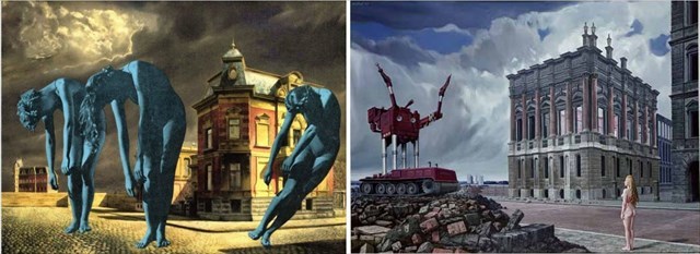
[Opdracht WP01]: A= Het beeld is gemaakt door ‘_ _ _ X _ _ Willink’ (4de letter)
Wanneer je richting [WP02] loopt kom je de woning tegen die als eerste is gebouwd in de Pijp, het toont het jaar 1874 op de gevel. Als je daar even de hoek omgaat ben je dicht bij een leuke traditional cache.
Al snel zijn de woningen van minder luxe voorzien en is er gebouwd om de vele arbeiders, kunstenaars, studenten en ook prostituees te huisvesten. Met deze rijke pluimage werd het echter wel super gezellig in de Pijp. Er ontstond veel horeca en er was cabaret. Zodoende wordt dit deel van de Pijp ook wel het Quartier Latin genoemd, als referentie naar de studentenwijk in Parijs.
[WP02] Mineralen en fossielen
Hygiënisch wonen
Enkele woningblokken in dit deel van De Pijp zijn gebouwd in opdracht van de ‘Vereeniging ten behoeve der Arbeidersklasse’. Deze vereniging legde zich als eerste toe op het bouwen van hygiënische woningen voor arbeiders tegen een redelijke huur om de verspreiding van ziektes zoals cholera, tyfus en tuberculose tegen te gaan.
Ook de architectuur kreeg de nodige aandacht. P.J. Hamer was de ‘huisarchitect’ van de vereniging. Hij hield zich intensief bezig met volkshuisvesting en ontwierp, vaak samen met zijn zoon Willem, vele woningblokken in De Pijp en de Jordaan, onder andere het symmetrische complex uit 1874 op de hoek van de Ruysdaelkade (nr. 57) en de Eerste Jacob van Campenstraat (nr. 3-21).
Klein wonen
In het complex waren oorspronkelijk 130 arbeiderswoningen, éénkamer woningen of woningen van het rug-aan-rugtype, die door een dunne scheidingswand in twee kleine halve woningen waren verdeeld. Beide hoeken van de Eerste Jacob van Campenstraat met de Ruysdaelkade zijn van oudsher ingericht als winkelruimte.
Een buste van Jacob van Campen, de vermaarde architect van het als stadhuis gebouwde Koninklijk Paleis op de Dam, hangt boven de deur van:
[Opdracht WP02]: B = ‘Mineralen en fossielenwinkel _ _ _ _ _ _ _ X’ op nummer 2 (8ste letter)
[WP03] Amsterdam Street Art

Fabrice is een bekende Nederlandse beeldend kunstenaar. Fabrice maakt schilderijen, tekeningen en sculpturen. Hij heeft in Amsterdam bekendheid gekregen met het beschilderen van muren en dergelijke, zoals hier in de Quellijnstraat en iets verderop de zuil op het Marie Heinekenplein. Fabrice heeft zijn eigen Galerotiek aan de Jacob van Lennepkade en heeft zijn eigen website:
[Opdracht WP03]: C = ‘www.fabrice._ X’ (2de letter, is de laatste letter)
[WP04] Marie Heineken
Je bent op het Marie Heinekenplein, met wederom een kunstwerk van Fabrice. Op de plek van het plein stond oorspronkelijk een deel van de Heinekenbrouwerij. Dit deel van de brouwerij werd in 1988 gesloopt, en in 1993 sloeg Freddy Heineken de eerste paal voor het huidige plein, dat dus ‘Heinekenplein’ was gedoopt.
De naam van het plein zorgde voor veel discussie vanwege de regels dat straten in Amsterdam niet naar bedrijven of naar nog levende personen vernoemd mogen worden. Bovendien ligt het plein in het deel van de Pijp waar de straten zijn vernoemd naar Nederlandse schilders en kunstenaars, alhoewel je natuurlijk het brouwen van bier ook tot kunst kunt verheffen. Maar er kwam een eenvoudige oplossing waar iedereen zich in kon vinden. Het plein is uiteindelijk in 1994 vernoemd naar Marie Heineken, een schilderes en nicht van Gerard Adriaan Heineken, oprichter van de brouwerij Heineken.
[Opdracht WP04]: D = ‘Op de Rijksakademie van _ _ X _ _ _ _ _ _ kunsten (3de letter)
[WP05] Gerard Douplein
Dit plein is een uitgaansgebied met tal van horecagelegenheden, van café tot snackbar. Op het plein staat een kunstwerk bestaande uit drie verlichte pilaren (Zuilen van Henk Duijn, 1996). Een vierde pilaar wordt even verderop gevormd door een peperbus. Frederik van Eeden heeft op een hoek van het plein een gedicht hangen: ‘Avond in de Stad…’
[Opdracht WP05]: E = ‘…brengt een vaag en wonderlijk _ _ X _ _ _’ (3de letter)
Op weg naar [WP06] loop je door een deel van de wijk dat aansluit op de noord-zuid straten van de eerste bebouwing. Kijk even achterom naar de hoekwoningen die ook wel de ‘taartpunten’ van de wijk worden genoemd.
[WP06] Synagoge
Een beetje onopvallend tussen de huizen staat hier een synagoge. De eerste synagogen in Amsterdam werden gedurende de zeventiende eeuw gebouwd in de buurt van het Waterlooplein, waar toen de Jodenbuurt was. De synagoge hier aan de Gerard Doustraat is in 1892 gebouwd; in die tijd waren de eerste joden in de toen nog nieuwe buurt De Pijp komen wonen. In de synagoge is plek voor 250 mannen en 70 vrouwen.
[Opdracht WP06]: Ok, hier moet je bepalen wat de waarde van ‘F’ is. Dit loopt even anders.
F = Het huisnummer waar de synagoge gevestigd is. Tel de individuele getallen waar dit huisnummer uit bestaat bij elkaar op, en je hebt F. Hint; als je op ongeluk uitkomt heb je geluk.
Nadat Hitler in 1933 in Duitsland aan de macht was gekomen, vluchtten er opnieuw veel joden naar Amsterdam. Ze waren bang voor vervolging door de nazi’s. Een aantal van hen vestigde zich in Zuid, vooral in de Rivierenbuurt. Toen de Duitsers Nederland bezetten, merkten ze de synagoge in de Gerard Doustraat niet op. De diensten konden er tot in 1943 doorgaan. Direct na de Tweede Wereldoorlog werd de synagoge weer in gebruik genomen.
[WP07] Albert Cuyp & Andre Hazes
Je bent nu op de Albert Cuyp markt. Deze loopt van de van Woustraat tot de Ferdinand Bolstraat. Voordat de Pijp bebouwd werd, was dit de Zaagmolensloot. Een afwateringsloot van de Binnendijksche Buitenveldersche polder, waar vanaf 1640 zaagmolens werden geplaats.
De Albert Cuypmarkt bestaat sinds 1905. Het is met zijn 260 kramen de grootste dagmarkt van Europa. Loop een stukje over de Albert Cuyp tot de Eerste Sweelinckstraat. Op deze hoek staat een standbeeld van onze bekendste volkszanger van Nederland, André Hazes.
[Opdracht WP07]: G = ‘Heel bijzonder, Heel _ _ _ X _ _’ (4de letter)
Pssst: hier ligt ook een traditional cache op je te wachten…
[WP08] Sarphatipark gemaal
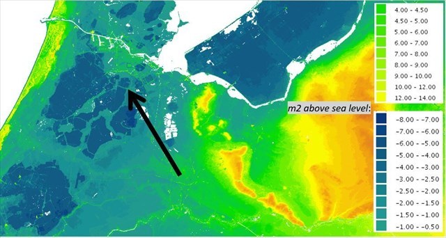
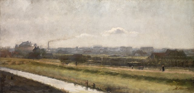
De Binnendijksche Buitenveldersche polder, waar nu de Pijp ligt, lag op sommige plekken wel 7 meter onder het zeewaterniveau en werd drooggehouden met vier windmolens. Deze zijn in 1877 vervangen door stoomgemalen. Tijdens de bebouwing is de grond echter flink opgehoogd, en zijn er ontelbaar veel palen de grond ingeslagen ter ondersteuning van de fundering. Denk aan de inleiding dat we te maken hebben met moerassig landschap bestaande uit veengronden, in plaats van stevige zandgronden.
Het Sarphatipark is echter niet opgehoogd. Met deze reden staat in het kleine huisje bij de ingang aan de westkant van het park waar je bent binnengekomen, nog steeds een gemaaltje te draaien. Deze voert vers water in vanuit de Singelgracht en voert vervuild en overtollig water af naar diezelfde waterweg. Het is ook een plek waar bewoners van De Pijp planten, stekken en zaden uit hun tuin of geveltuin kunnen ruilen of weggeven.
[Opdracht WP08]: H = ‘…dat druipendbruin in ’t _ _ _ _ _ _ _ _ _ _ _ X _ _ zonnetje lag’ (12de letter)
[WP09] Sarphatimonument
In het jaar 1885 werd begonnen met de aanleg van dit park. In het Park staat een monument met een borstbeeld van Samuel Sarphati.
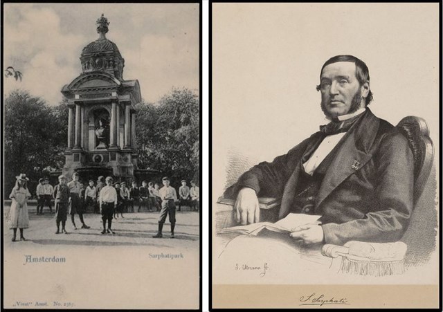
[Opdracht WP09]: I = ‘Stichter _ X _ ’t Nieuw Amsterdam Sarphati’ (2de letter)
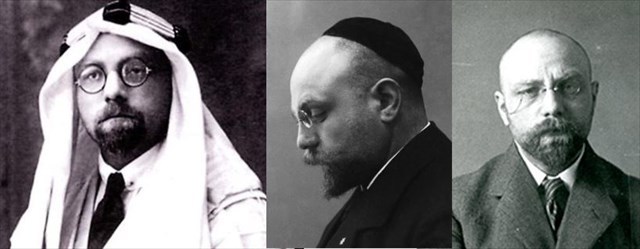
De goede man (1813 - 1866) was een Joods arts, chemicus, weldoener en broodfabrikant die een belangrijke rol speelde in de ontwikkeling van het onderwijs, de volksgezondheid, de stedenbouw en de nijverheid van Amsterdam in het midden van de 19e eeuw. Sarphati was van alle markten thuis en liep met zijn initiatieven vaak vast in de Amsterdamse bureaucratie.
Tijdens de Duitse bezetting van Nederland in de Tweede Wereldoorlog kregen alle straten en dergelijke die vernoemd waren naar Joden een andere naam en zo werd het Sarphatipark omgedoopt tot Bollandpark, naar een Nederlandse filosoof en taalkundige. Uit het monument werd het borstbeeld van Sarphati verwijderd.
Een traditional cache is hier in 2019 geplaatst als onderdeel van een 'Amsterdam-trail' van individuele caches.
[WP10] Kabouterhuis
Wanneer je het Sarphatipark uitloopt in het oosten, is dit het uitzicht in 1926 langs de Ceintuurbaan, in de richting van [WP10]. Links het hoekhuis Sarphatipark 137. Op de achtergrond de Sint-Willibrorduskerk die helaas in de jaren 60 van de vorige eeuw werd gesloopt.
Over het waarom van de groene kabouters doen verschillende verhalen de ronde. Die verhalen variëren van de achternaam van de opdrachtgever (Van Ballegooyen) tot de manier waarop de bouw van de huizen tot stand is gekomen: de samenwerking tussen twee aannemers die elkaar ‘de bal toespeelden'. De kabouters hebben altijd aantrekkingskracht gehad op de kinderen uit de Pijp. Het lijkt namelijk een mysterie te zijn welke kabouter de bal heeft. De bal zou stiekem door de kabouters worden overgegooid, maar onduidelijk is of dat gebeurt om middernacht, met oudjaar of in schrikkeljaren.
[Opdracht WP10]: J = ‘De combinatie van neogotische elementen als spitsbogen en _ _ _ X _ _ _ met kruiskozijnen….’. (4de letter)
Steek de weg over en loop een stukje terug om uiteindelijk [WP11] te bereiken.
[WP11] Jacob de Haan
Sint Willibrordusstraat 29:
Hier woonde de Nederlands joodse schrijver en onderwijzer Jacob Israël de Haan vanaf februari 1903. In 1904 publiceerde Jacob Israël de Haan de roman Pijpelijntjes, een van de eerste Nederlandse boeken waarin een homoseksuele relatie openlijk beschreven staat. Homoseksualiteit was in die tijd een schokkend onderwerp. De Haan betaalde daarom ook een prijs voor de publicatie. Hij mocht geen les meer geven, en hij werd ontslagen bij de krant waarvoor hij werkte.
Het boek gaat over de moeizame liefdesrelatie tussen de studenten Joop en Sam, die in De Pijp wonen. Sam worstelt met zijn homoseksualiteit. Hij is vaak gemeen tegen Joop. Uiteindelijk verlooft Sam zich met een vrouw en verbreekt hij zijn relatie met Joop.
[Opdracht WP11]: Schuin aan de andere kant van de weg is een fietsenzaak. Welk beroep had de persoon wiens naam deze straat draagt? Ps: dit is een Google zoek actie! Tip: hij oefende dit min of meer muzikale beroep uit op het Stadhuis op de Dam. Het beroep begint met een ‘k’ en eindigt op een ‘t’.
K = _ _ _ _ _ X _ _ _ _ (6de letter)
Loop tussen de huizenblokken door op weg naar [WP12], ergens links aan de muur vind je een gedenksteen voor Jacob de Haan.
[WP12] Polderhuis
Het Polderhuis in de Amsterdamse Pijp is een bijzonder arbeiderswoninkje, dat in 1865 werd gebouwd in het dorpje Meerhuizen. Meerhuizen lag toen in de gemeente Nieuwer-Amstel, dat door Ouderkerk aan de Amstel in het zuiden werd bestuurd. Sterker nog, Ouderkerk aan de Amstel was de allereerste nederzetting in dit hele Amstelgebied, ver voordat Amsterdam überhaupt bestond (zie de interessante Geocaches die daar liggen). Maar Amsterdam was veel groter en sterker geworden en raakte in de 18de eeuw overbevolking en kampte met epidemieën. Tijdens de uitbreiding werden steeds meer stukken van Nieuwer-Amstel geannexeerd, opgehoogd en volgebouwd. Dit oudste huisje heeft de tijd overleefd; je ziet dat het gebouwd is op het originele polderniveau. Nieuwer-Amstel werd in 1964 omgedoopt tot het huidige Amstelveen.
Zie je de toenmalige grens tussen Amsterdam en Nieuwer-Amstel als stippellijn op het kaartje vermeld staan? Bij 'Tol' moest tol betaald worden. Hier werd later het raadhuis gebouwd dat je zo zult passeren, in een poging de verdere uitbreiding van Amsterdam tegen te gaan. Je kunt ook het dorpje Meerhuizen, een stoomgemaal en twee buitenhuizen langs de Amstel vinden. Geocache GC3P3R8 vertelt je meer over deze buitenhuizen.
[Opdracht WP12]: L = ‘Autoschade J. _ _ X _ _ _ _ & Zn.’ (3de letter)
Mocht je je afvragen wat deze tekst hier doet? Het is een in 2002 gerestaureerde reclameschildering van een autoschadebedrijf dat tot circa 2000 in een gebouwtje achter het polderhuis was gevestigd.
Volg op weg naar [WP13] de Amstel, je passeert het oude raadhuis van de hiervoor genoemde gemeente Nieuwer-Amstel.
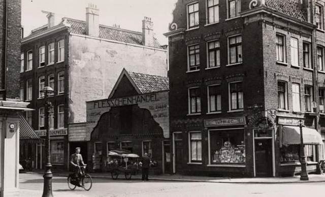
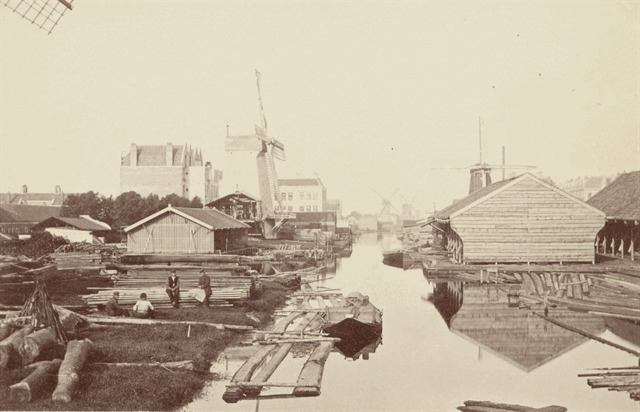
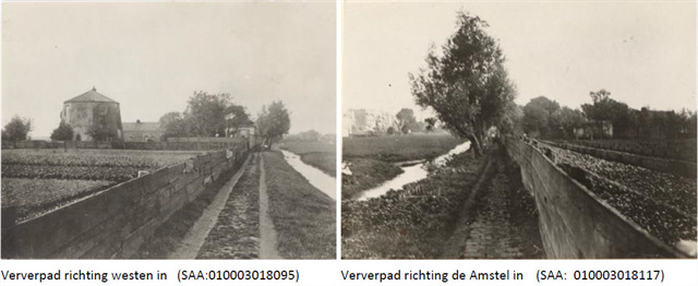
Zo veel glorie als de buitenhuizen en het raadhuis langs de Amstel uitstraalden, zo eenvoudig was het leven in het achterland van de polder. Je slaat nu de Tolstraat in op weg naar [WP13]. Het achtergebied van de Amsteldijk was tot de bebouwing van de Pijp in gebruik voor warmoezerijen (groentekwekerijen), veeteelt en door molens opgewekte industrie (zoals de houtzagerijen aan de huidige Albert Cuyp). Er liepen, zoals je inmiddels weet, van oost naar west afwateringssloten, maar ook weggetjes (‘ontsluitingswegen’). Langs die wegen woonde het gepeupel, de arme, hardwerkende, noeste arbeider. De Rustenburgerstraat, waar je het Polderhuis zag, heette vroeger het ‘Rust en Werkpad’. De Ostadestraat welke je eerder bent overgestoken heette ‘Het Hoedemakerspad’. De Tolstraat waar je nu bent, een naam die verwijst naar de tol die betaald moest worden wanneer je Amsterdam binnentrok, was het belangrijkste pad naar het achterland. Het heette toen ‘Het Verwerspad’. Zo zag dit pad er rond 1900 uit (herken je de romp van de molen?):
[WP13] Diamantslijperij
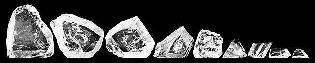
De Joodse gemeenschap houdt zich al eeuwen bezig met het slijpen van diamanten, waar een boek over geschreven kan worden, wat dan ook veelvuldig is gedaan. Ergens in de 14de eeuw is het diamantslijpen uitgevonden. Eerst waren het Antwerpen en Brugge waar de belangrijkste diamanthandel zich concentreerde, daarna verhuisde dit naar Amsterdam. In Amsterdam bestond er geen gilde voor de diamantslijperij wat maakte dat het voor de Joodse bevolking mogelijk was om in deze industrie te gaan werken. In Amsterdam waren er zo’n 9000 mensen werkzaam in deze industrie.
Deze diamantslijperij bouwde in het begin van de 20e eeuw een internationale reputatie op met een belangrijke splijt/slijp-techniek, een opvallende achthoekige slijpvorm die meteen erg in trek was. In 1907 werd de fabriek geopend waar je nu voor staat. De diamantslijperij valt op door de vele ramen en de kantelen op het dak waardoor het gebouw wel iets heeft van een kasteel of een middeleeuwse kerk.
Diamanten krijgen namen. ‘De Cullinan’ is de grootste diamant ooit gevonden (meer dan een halve kilo), en is door dit bedrijf gekloofd in 105 afzonderlijke diamanten, die daarna zijn geslepen. Deze stenen prijken in de Britse kroonjuwelen; de eigenaren mochten de kleinere stenen houden als loon.
[Opdracht WP13]: M = ‘Diamantslijperij I.J. _ _ _ _ X _ _ ‘ (5de letter)
Het blok met lage huisjes in de Diamantstraat tegenover de slijperij, is in 1891 gebouwd in opdracht van Gerard Adrianus Heineken, eigenaar van de bierbrouwerij en destijds ook directeur van de Woningmaatschappij. Heineken kon de grond waarop de woningen staan destijds goedkoop krijgen omdat het nog deel was van de gemeente Nieuwer-Amstel. In de hoogtijdagen van de diamantslijperij woonden er veel werknemers van de fabriek. Het deel rondom en ten zuiden van deze huisjes is in de architectuur stijl van de Amsterdamse School gebouwd. Dit gebied laten we letterlijk links liggen, aangezien hier een andere multi cache op je ligt te wachten.
[WP14] Fiets Anne Frank
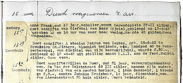
Op 14 februari 1942 stapte de twaalfjarige Anne Frank dit politiebureau binnen dat toen hier aan de Pieter Aertszstraat 5 zat. Het was een klein politiebureau. Ook tijdens de Duitse bezetting ging het gewone werk er door. Er kwamen aangiftes binnen van Amsterdamse joden die op straat waren aangevallen, maar ook van diefstal van tasjes of juwelen. Anne Frank deed er die middag om tien over drie aangifte van de diefstal van haar fiets. In haar dagboek klaagde Anne op 24 juni 1942 over de diefstal: ze moest in de zomerhitte lopen naar school, omdat haar fiets gestolen was en Nederlandse Joden niet meer met de tram mochten.
[Opdracht WP14]: N = Wat is het nummer van het oude politiebureau? Tel deze getallen bij elkaar op en je krijgt N
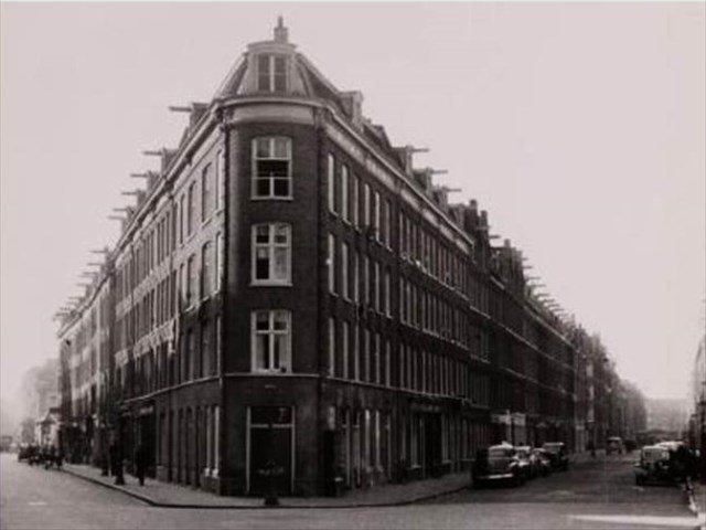
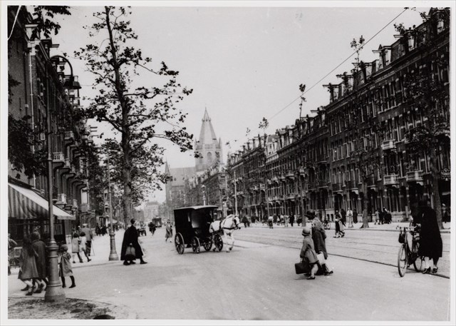
Op weg naar [WP15] passeer je het Henrick de Keijserplein. Zo zag het er rond 1900 uit. 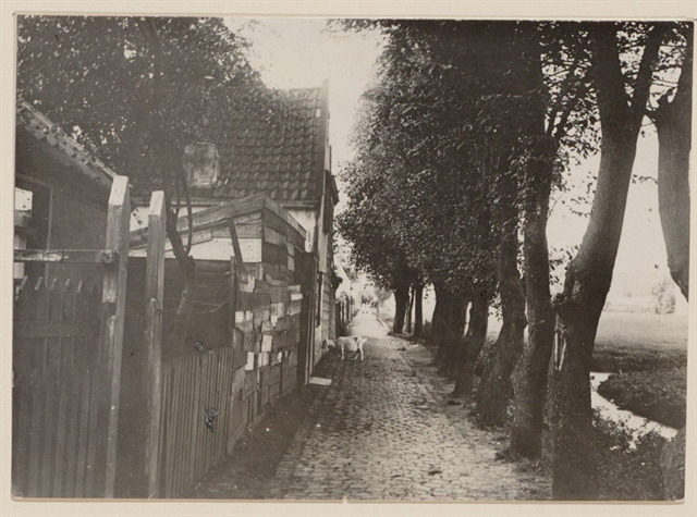
[WP15] Hindoetempel
Aan de Karel du Jardinstraat is een Hindoe ‘tempel’ gevestigd. De ‘tempel’ is opgezet door hindoestanen uit Suriname.
[Opdracht WP15]: O = ‘Shri _ _ _ _ _ X MandiEr’ (6de letter)

Nadat Nederland de slavernij in 1863 had afgeschaft waren er nieuwe goedkope arbeidskrachten nodig om op de plantages in Suriname te werken. De Nederlanders haalden toen contractarbeiders uit onder meer India. Deze hindoestanen werden geworven met mooie beloftes, maar werden bij aankomst verplicht om tegen een heel laag loon een aantal jaar op de plantages te werken. In totaal zouden meer dan dertigduizend Indiërs als onvrije en vrijwel rechteloze contractarbeider naar Suriname komen. Toen Suriname in 1975 onafhankelijk werd verhuisden veel van hun nazaten naar Nederland. In Nederland wonen tegenwoordig zo’n 120.000 hindoestanen. Deze Hindoetempel zit hier al sinds 1984.
[WP 16] Klooster
In dit monumentaal pand naar de stijl van de Amsterdamse School stijl zit nu de volgende lokale bierbrouwerij:
[Opdracht WP16]: P = Brouwerij _ _ _ X _ _(4de letter)
Oorspronkelijk was dit gebouw een broeder- en nonnenklooster met een scholencomplex, behorende bij de Vredeskerk. Het werd in 1928 in gebruik genomen.
In de Tweede Wereldoorlog werd het door de Duitse bezetters gevorderd en kreeg het complex de naam Tulpkazerne, genoemd naar Sybren Tulp, toenmalig hoofdcommissaris van Amsterdamse politie en NSB-er. Hij vormde een speciale eenheid met ruim 250 leden, de 'Schalkhaarders'. Alleen de gehuwde mannen was het toegestaan, indien zij geen dienst hadden, thuis te overnachten. Onder Tulps bevel werd een Nederlands politiebataljon ingezet om Joden op te pakken. Na de capitulatie in mei 1945 werd de naam ‘Tulpenkazerne’ uiteraard direct verwijderd en is het complex in gebruik genomen door de Koninklijke Marechaussee, van 1977 tot 1997 zat de Bhagwanbeweging erin, daarna behoorde het tot het UWV, vervolgens ging de politie erin en nu eindelijk, na een bewogen geschiedenis, is de rust wedergekeerd in de vorm van een kleinschalige bierbrouwerij; weer een beetje terug bij de broeders dus.
[Opdracht WP17]: De Cache
YES, JE KUNT OP ZOEK NAAR DE VERBORGEN WP17, OFTEWEL DE CACHE!!
De cijferwaarde van letters A t/m P zijn niet uniek, sommige getallen komen vaker voor. Controle: som (A t/m P) = 203
Bereken nu Q t/m Z:
Q = B – P – N + I = ?
R = C – O = ?
S = J – G + I = ?
T = K + L – I = ?
U = J – A + N = ?
V = F – H = ?
W = F – E – I = ?
X = B – O = ?
Y = C – D – E = ?
Z = H + M – K – L = ?
Ook binnen de letters Q t/m Z komen dezelfde cijferwaarden voor. Controle: som (Q t/m Z) = 53
De cache ligt op (en zo voer je hem ook in Google Maps in, de N van 'North' en E van 'East' laten staan):
N 52 QR.STU E 4 VW.XYZ
Wanneer je daar bent heb je nog een code van cijfers nodig 😊, namelijk [ IHKL ]
We hopen dat je een plezierige en beetje leerzame middag hebt gehad! Wanneer je doorloopt naar het oosten, bereik je de Ruysdaelkade met een klein rijtje 'peeskamers'; het laatste overblijfsel van roerige tijden van weleer. Dit woord is afkomstig van het werkwoord 'uitpezen', wel aardig om eens op te Googelen. Teruglopende naar het startpunt kom je nog een laatste traditional tegen.
Geocache 'de Pijp in the 20th century’
***THIS ENGLISH VERSION WENT ONLINE APRIL 15TH 2019; IF YOU ENCOUNTER ANY PROBLEMS, PLEASE LET US KNOW***
About the cache
This Multi cache, of approximately 5.5 km, shows you the historical development of the neighborhood ‘de Pijp’ in Amsterdam. It would take you maybe half a day, especially if you want to find the few additional traditional caches that you will pass, and want to enjoy one of the many terraces to have a drink. Experience has shown that the faster Geocachers take one and a half hour, using their bike or scooter. Along the way, you collect data that will help you find the cache for the end point of given coordinates. The cache container is large enough to hold a small trackable.
Ok, and especially for this English version: only at a few locations, we were able to find an English text. Therefore, most text that you are searching for, in written in Dutch. But we trust that you will be able to find the information needed. You might not understand the sentences mentioned, therefore we have tried to translate these Dutch phrases into English. Well, you might pick up a few Dutch words this way. 😊
Super short introduction
In the year 1874, the first stone was laid in the northwest of the district, where the route begins. Before, there only was a polder landscape where cows were grazing and windmills were sawing wood along the drainage ditches dug in the landscape. This polder was called the ‘Binnendijkse Buitenveldertse polder‘, which can be translated as something as 'the outside field within the dikes of the polder’. The polder was laid dry around 1630. Until then, this area was a marshy landscape consisting of peat bogs; just like the whole area around the Amstel and even the largest part of the western part of the Netherlands. There were already some fantastic large villa’s along the Amstel river though, which served as the second home for the wealthy residents of Amsterdam. There were also some farms in the district 'Meerhuizen'.
Meerhuizen was a neighborhood that originally fell within the municipality 'Nieuwer-Amstel', which was controlled by Ouderkerk aan de Amstel, further south. Before our capital Amsterdam was powerful enough to become independent, Ouderkerk aan de Amstel was the first settlement of prestige and controlled the entire area. The municipality of Nieuwer-Amstel has in the course of time been reduced to the current city of Amstelveen. Just a few dates; the oldest document found that mentions Amsterdam comes from 1275, but excavations during the North-South metro line has set Amsterdam's origins one hundred years earlier. Ouderkerk aan der Amstel is said to have existed some one hundred to two hundred years earlier than Amsterdam.
Do you wonder where those people came from at all? The first settlers came from the Utrecht region (middle Netherlands), which lies naturally much higher on sandy grounds. This has everything to do with "the Great Land Reclamation" that started in the 10th century; a Dutch-to-English translated term that I couldn’t find information upon in English. This relates to the typical historical Dutch phenomenon of cultivating impenetrable, low-lying peat regions in the western part of the Netherlands. Think of people searching for a natural higher place in the landscape (as curves in the Amstel river with clay deposits), cutting the wild vegetation in the surrounding area, digging parallel ditches, leveling the ground, constructing dikes around it and getting rid of excess water with the help of windmills. A process that is directly reflected in the street pattern of the Pijp that you will soon discover.….
From 1874 onwards, de Pijp has been developed in four phases from North to South, which you will pass on the way. Each period has its own architect, vision and architectural style. The first houses in the northwest were still relatively large dwellings. The architect had great plans with de Pijp. According to his drawings, the present green area in the middle called Sarphatipark, should have been the Amsterdam central station! The streets in this northwestern corner runs from north to south (see map), perpendicular to the existing drainage ditches and walkways within the original polder.
Soon this plan proofed to be unfeasible. Besides, a lot of new homes were needed as soon as possible. The existing Amsterdam at that time, until the present ‘Stadhouderskade’ (the last canal belt) was overcrowded and full with epidemics. In addition to scurvy and syphilis there was smallpox, dysentery, flu, typhus, tuberculosis and cholera, called ‘the blue death’. Therefore, the rest of the northern part of de Pijp was built with cheap ‘workers houses’, where many students and artists rented a room. Some houses along the Ruysdaelkade were intended for prostitutes, and still are. Streets followed the original drainage ditches here; that was a lot easier to organize. Poets and writers have described the sad housing conditions extensively. At the same time, the area was considered as very lively and cozy.
Halfway de Pijp, another architect took over around the year 1900. He continued working with the original plans, but he wanted more creativity and variety, as bended streets. The people living there got more space, more green and more squares. House blocks were built side by side in the same style. More and more attention was also paid to the hygienic conditions with public bathhouses. He hoped the worker would take a shower here at least once a month. In the most southern part of de Pijp the worker got even better living facilities with the architectural style called ‘Amsterdamse school’. An individual dwelling would get their own shower! But since the water was not heated yet, most bathrooms became an areas for additional storage space.
How to solve the geocache?
If you are experienced, you will know this section. The puzzles are deliberately kept simple. At any point you find a text near the specified coordinate (your waypoint WP). In a (often Dutch) sentence, a word is omitted. Enter the correct word here. Write the letter in the position 'X'. What place in the alphabet has this letter? Fill in this number.
As an example: "A = here formerly lived the _ _X_ _ _ _." (3rd letter)
On the sign you for instance find 'here formerly lived the painter' The letter you are looking for is the ’I’, the third letter in the searched word (which is always mentioned). This is the 9th letter in the alphabet (this you have to figure out yourself). That means: I = 9. The underscore '_' always stands for a letter; do not fill in any spaces. This way you have to search for the values of the 16 letters A through P, which are given at 16 waypoints [WP's]. These letters are not unique, so some letters get the same number, which is ok. Then, in formulas, they will give you the values for Q through Z, which in turn give the coordinates of the final cache. When you have reached the final cache, you will need an additional code to get to the logbook....
Starting point
You can reach ‘de Pijp’ by metro or tram 24 from Central Station. Station ‘Vijzelgracht’, just north of de Pijp is a nice starting point since you will pass by the northern part of de Pijp, the oldest part, on your the way to [WP01]. Here you can pick up as well the first traditional cache. Starting from the Rijksmuseum to reach [WP01] is also an option.
[WP01] Magical realism
You will find references to painters everywhere in de Pijp. This is the first one. You are at the ‘Carel Willink-plantsoentje’ (little park). Carel Willink is seen as the most important painter of magic realism, a painting style that creates an alienating atmosphere with light, colour, shape and depth. He tried to paint 'the imagination', 'as realistically as possible'.... a beautiful impossible challenge.
[Instruction WP01]: A= Het beeld is gemaakt door ‘_ _ _ X _ _ Willink’ (4th letter)
English translation: ‘This statue was placed on the occasion of his 100th birthday on March 7, 2000 by the district of Amsterdam South. The statue was made by _ _ _ X _ _ Willink.’
When you walk towards [WP02] you will come across the house which was first built in de Pijp; it shows the year 1874. If you walk around the corner, you are close to a nice traditional cache.
Soon the houses are of less luxury and have been built to accommodation the many workers, artists, students and also prostitutes. However, with this variety of people it was very cosy in de Pijp. There were a lot of bars and restaurants and there was cabaret. This part of de Pijp is therefore called the Quartier Latin, as a reference to the student district in Paris.
[WP02] Minerals and Fossils
Hygienic living
Some dwelling blocks in this part of de Pijp are built on half of the 'Association for the benefit of the working class'. This association advocated more hygienic dwellings for workers at a reasonable rent to prevent the spread of diseases such as cholera, typhoid and tuberculosis (remember the previous situation in the center of Amsterdam….).
The architecture was also given the necessary attention. P.J. Hamer was the ' house Architect ' of the association. He worked intensively on public housing and, often together with his son Willem, designed many blocks of dwellings in de Pijp and the Jordaan, including the symmetrical complex from 1874 at the corner of the Ruysdaelkade (No. 57) and the Eerste Jacob van Campenstraat (No. 3-21).
Living in small houses
The complex had originally 130 small apartments for the working-class, often one-room apartments. Some apartments were of the ‘back-to-back’ type, which were divided into two small half-dwellings, using a thin inner wall. Both corners of the Eerste Jacob van Campenstraat and the Ruysdaelkade that you are looking at have traditionally been erected as a shopping area.
A bust of Jacob van Campen, the renowned architect of the royal palace built as a city hall on the Dam, hangs above the door of:
[Instruction WP02]: B = ‘Mineralen en fossielenwinkel _ _ _ _ _ _ _ X’ op nummer 2 (8th letter)
English translation: ‘Minerals and fossil store _ _ _ _ _ _ _ X’
[WP03] Amsterdam Street Art
Fabrice is a famous Dutch visual artist. Fabrice makes paintings, drawings and sculptures. He gained fame in Amsterdam with the painting of walls as here in the Quellijnstraat. A little further down on the Marie Heineken Square (next WP), you can find another Fabrice, which you will recognize by the style. Fabrice has his own Galerotiek at the Jacob van Lennep Kade and has his own website:
[Instruction WP03]: C = ‘www.fabrice._ X’ (2nd letter, this is the last letter)
You don’t need an English translation here 😊
[WP04] Marie Heineken
You are at the Marie Heineken square. Here, originally a part of the Heineken Brewery stood. This part of the brewery was demolished in 1988, and in 1993 Freddy Heineken, the owner at that moment, laid the first stone for the current square, which was thus baptized 'Heineken Square '.
But the name of the square caused a lot of discussion because of the rules that streets in Amsterdam should not be named after companies or even living people. Moreover, the square is located in the part of de Pijp where the streets are named after Dutch painters and artists, although of course you can also raise the brewing of beer to the level of art. But suddenly there was a simple solution that everyone could accept. The square was finally renamed after Marie Heineken, a painter and niece or Gerard Adriaan Heineken, founder of the Heineken Brewery.
[Instruction WP04]: D = ‘Op de Rijksakademie van _ _ X _ _ _ _ _ _ kunsten (3rd letter)
English translation: ‘Her father was the merchant Wijnand Heineken, an uncle of the beer brewer Gerard Adriaan Heineken. At the National Academy of Visual Arts in Amsterdam she received painting lessons from August Allebé. Her work consists of floral still lifes, cityscapes, landscapes and some portraits. Marie Heineken (1844-1930).’
[WP05] Gerard Douplein
This Square is a nightlife area with numerous restaurants, bars and snack bars. The square contains three illuminated pillars (Columns of Henk Dels, 1996). A fourth pillar is formed a little further by an advertising column. Frederik van Eeden has a poem on a corner of the square: ' Evening in the city... '
[Instruction WP05]: E = ‘…brengt een vaag en wonderlijk _ _ X _ _ _’ (3rd letter)
English translation: ‘Evening in the city. The greatest voice of the city is silent, and the night wind that comes in my window brings a vague and wonderful whisper like the sighs of sleeping houses. Frederik van Eeden (1908).’
On the way to [WP06] you walk through a part of the district that connects to the north-south streets of the first building. Look back at the corner houses which are also called the 'pie points ' of the district.
[WP06] Synagogue
A little inconspicuous between the houses is a synagogue here. The first synagogues in Amsterdam were built during the seventeenth century near the Waterloo Square, where the Jewish quarter was. The synagogue here at the Gerard Doustraat was built in 1892 when the first Jews came to this new neighbourhood. The synagogue fits 250 men and 70 women.
[Instruction WP06]: Ok, here you have to determine what the value of ' F ' is. This goes a little bit different.
F = The House number where the synagogue is located. Count the individual numbers where this house number consists of, and you have F. Hint; the number that you are searching for is quite an unlucky number in some countries, except for you Italian guys and girls, were you love this number, according to Wikipedia 😊
After Hitler came to power in Germany in 1933, many Jews fled to Amsterdam again. They were afraid of persecution by the Nazis. Some of them settled in the southern parts, especially in the ‘Rivierenbuurt’ (River neighbourhood). When the Germans occupied the Netherlands, they did not notice this synagogue. The services could continue until 1943. Immediately after the Second World War, the synagogue was re-opened.
[WP07] Albert Cuyp & Andre Hazes
You are now on the Albert Cuyp market (named after a painter). The market runs from the ‘van Woustraat’ (named after a bell founder ) to the ‘Ferdinand Bolstraat’ (again a painter). Before de Pijp was built, this was the ‘Zaagmolensloot’ (Sawmill ditch). A drainage ditch from the original polder, where from 1640 onwards saw mills were placed.
The Albert Cuyp market exists since 1905. With its 260 stalls it is the largest open air market of Europe. Walk a bit across the Albert Cuyp until the ‘Eerste Sweelinckstraat’ (a composer, organist). At the corner is a statue of our most famous folk singer of the Netherlands, André Hazes, who died in 2004.
[Instruction WP07]: G = ‘Heel bijzonder, Heel _ _ _ X _ _’ (4th letter)
English translation: ‘Very special, very ordinary. Just a very special man. Andre Hazes (1951 – 2004)’. The text probably links to the funeral speech of the previous mayor Cohen of Amsterdam: ’André was an ordinary boy, but at the same time very special because of the power of his voice and the power of his songs’.
Pssst: here a traditional cache is waiting for you...
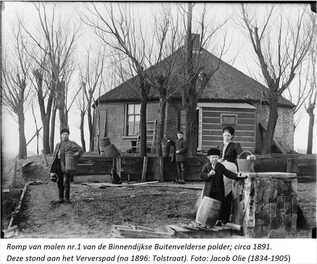
[WP08] Sarphatipark water pumping station
The original polder of de Pijp, lied at some places 7 meters below the seawater level. It was kept dry with four windmills. The picture shows the hull of one of the mills. These were replaced in 1877 by pumping stations, powered by a steam engine. During the construction of the apartments however, the ground has been raised considerably. As well, countless wooden poles have been driven into the ground to support the foundation. Remember from the introduction that we are dealing with marshy landscape consisting of peat bogs, instead of firm sandy soils.
This park however, has not been raised. Therefore, a pumping station is still running in the small house at the entrance on the west side of the park where you have entered. This enters fresh water from the Singelgracht (the canal to the North) and transports polluted and surplus water to the same waterway. It is also a place where residents of de Pijp can exchange or give away plants, cuttings and seeds from their (facade) garden.
[Instruction WP08]: H = ‘…dat druipendbruin in ’t _ _ _ _ _ _ _ _ _ _ _ X _ _ zonnetje lag’ (12th letter)
English translation: well, we have to admit, we have no clue what this Dutch poem means. The verb ‘reeën’ is just no verb…the Google translation says:’ Along the Sarphatipark we can see that dripping-brown in the water-white-light sun’. Which would actually means that ‘reeën’ would be ‘to see’. Anyway, maybe someone can ask inside this building the meaning of the poem😊.
[WP09] Sarphati monument
Construction of this park began in 1885. Have a look at the monument with a bust of Samuel Sarphati..
[Instruction WP09]: I = ‘Stichter _ X _ ’t Nieuw Amsterdam Sarphati’ (2nd letter)
Sarphati (1813 - 1866) was a Jewish doctor, chemist, benefactor and bread manufacturer who played an important role in the development of education, public health, urban design and the industry of Amsterdam in the mid-19th century. Sarphati often got stuck in the Amsterdam bureaucracy with his initiatives.
During the German occupation of the Netherlands in World War II, all streets and the like that were named after Jews were given a different name and so the Sarphatipark was renamed Bollandpark, after a Dutch philosopher and linguist. The bust of Sarphati was removed from the monument.
A traditional cache was places here in 2019 as part of an ‘Amsterdam-trail’ of individual caches.
[WP10] Hobgoblins House
When you leave the park in the east, this is the view in 1926 along the Ceintuurbaan, in the direction of [WP10]. The building in the left corner is located at Sarphatipark 137. In the background you can see the Saint-Willibrordus church which unfortunately was demolished in the 60s of the last century.
There are various stories about the why of the green hobgoblins. One is about last name of the client; ‘Van Ballegooyen’, that sounds in Dutch as ‘to throw balls’. Another refers to the collaboration between the two contractors who "played the ball" to each other; which is a Dutch expression for ‘to organize benefits for each other’. The hobgoblins have always been attractive to the children from the Pijp. It seems to be a mystery which hobgoblins has the ball. The ball would be secretly thrown by the hobgoblins, but it is unclear whether that happens at midnight, New Year's Eve or in leap years.
[Instruction WP10]: J = ‘‘The combination of Gothic Revival elements such as pointed arches and gargoyles with four-paned X_ _ _ _ _ _’ (1st letter)
Cross the road and walk a bit back to finally reach [WP11].
[WP11] Jacob de Haan
Sint Willibrordusstraat 29:
The Dutch Jewish writer and teacher Jacob Israël de Haan lived here from February 1903. In 1904 Jacob Israël de Haan published the novel Pijpelijntjes, one of the first Dutch books in which a gay relationship is openly described. Homosexuality was a shocking subject at the time. De Haan therefore also paid a price for the publication. He was no longer allowed to teach, and he was fired from the newspaper he worked for.
The book is about the difficult love relationship between the students Joop and Sam, who live in de Pijp. Sam struggles with his homosexuality. He is often mean to Joop. Eventually Sam becomes engaged to a woman and breaks his relationship with Joop.
[Instruction WP11]: Diagonally on the other side of the road, at the corner, is a bicycle shop. Which street name does it have, other than the one that you are standing at right now?
K = _ _ _ _ _ X _ Noutsstraat (6th letter)
We were wondering who this guy was, maybe a saint, just as Sint Wilibrord…. But no, this guy was a ‘Beijaardier’. He was the first clock player of the Amsterdam City Hall on Dam Square, which is now the Royal Palace.
Walk between the blocks of houses on you way to [WP12], somewhere on the left side of the wall you will find a memorial stone for Jacob de Haan
[WP12] House of the polder (Polderhuis)
The Polderhuis is a special working-class house that was built in 1865 in the village of Meerhuizen. Meerhuizen was then located in the municipality of ‘Nieuwer-Amstel’, which was governed by ‘Ouderkerk aan de Amstel’ in the south. In fact, Ouderkerk aan de Amstel was the very first settlement in this entire Amstel area, long before Amsterdam even existed (see the interesting Geocaches that lie there). But Amsterdam had become much larger and stronger and in the 18th century it became overcrowded and was faced with epidemics. During the expansion, more and more pieces from Nieuwer-Amstel were annexed, raised and built upon. This oldest house has survived the time; you can see that it was built on the original, lower polder level. Nieuwer-Amstel was renamed the current Amstelveen in 1964.
Do you see the former border between Amsterdam and Nieuwer-Amstel as a dotted line on the map? At 'Tol' you had to pay tax to pass. At this spot the town hall that you will pass in a few minutes was built later in an attempt to prevent the further expansion of Amsterdam. You can as well find the village of Meerhuizen, a steam pumping station and two luxury country houses along the Amstel. Geocache GC3P3R8 tells you more about these country houses.
[Instruction WP12]: L = ‘Autoschade J. _ _ X _ _ _ _ & Zn.’ (3rd letter)
If you are wondering what this text does here? It is an advertising painting, restored in 2002, of a car damage company (‘autoschade’) that was located in a small building behind the polder house until around 2000. The ‘J. & Zn’ means ‘the man J. and his son’.
On the way to [WP13] follow the Amstel, and you will pass the old town hall of the aforementioned municipality of Nieuwer-Amstel.
As much glory as the country houses and the town hall radiated along the Amstel, life in the polder's hinterland was very simple. You will now turn into the Tolstraat on your way towards [WP13]. The hinterland of the Amsteldijk (Amstel dyke) was in use for vegetable farming, cattle breeding and mill-driven industries (such as the former sawmills on the Albert Cuyp market). As you know by now, drainage ditches ran from east to west, but also small roads. Along those roads lived the mob, the poor, hard-working, diligent worker. The Rustenburgerstraat, where you saw the Polderhuis, used to be called "Rust en Werkpad" (Rest and Work path). The Ostadestraat that you have crossed earlier was called "Het Hoedemakerspad" (Hatter's path). The Tolstraat where you are now, a name that refers to the tax that had to be paid when you entered Amsterdam, was the most important path to the hinterland. It was then called "The Verwerspad". See below, how this path looked like around 1900. The left picture towards the west (do you recognize the hull of mill?), the right picture towards the Amstel river.
[WP13] Diamond Factory
The Jewish community has for centuries been engaged in polishing diamonds, about which a book can be written, which has often been done. Somewhere in the 14th century diamond cutting was invented. First it was Antwerp and Bruges where the most important diamond trade was concentrated, then this moved to Amsterdam. In Amsterdam, there was no guild for the diamond cutting industry, which made it possible for the Jewish population to work in this industry. In Amsterdam there were around 9,000 people working in this industry.
This diamond cutting company (diamantslijperij) built up an international reputation at the beginning of the 20th century with an important splitting / polishing technique, a striking octagonal shape that immediately became popular. In 1907 the factory was opened which you now stand for. Notice the many windows and the battlements on the roof, which makes the building look like a castle or a medieval church.
Diamonds get names. "The Cullinan" is the largest diamond ever found (more than half a kilo), and is split by this company into 105 individual diamonds, which were subsequently cut. These stones adorn the British crown jewels; the owners of the company were allowed to keep the smaller stones as wages.
[Instruction WP13]: M = ‘Diamantslijperij I.J. _ _ _ _ X _ _ ‘ (5th letter)
The low houses in the Diamantstraat opposite the factory, were built in 1891 on behalf of Gerard Adrianus Heineken, owner of the beer brewery and at the time also director of the Housing Company. Heineken was able to buy the land cheap at the time because it was still part of the Nieuwer-Amstel municipality. In the heyday of the diamond factory, many employees lived here. The neighborhood around and to the south of these small houses is built in the architecture style of the ‘Amsterdam School’. We will ignore this area, as another multi-cache is waiting for you here.
[WP14] Bike Anne Frank
On 14 February 1942, the twelve-year-old Anne Frank entered this police station, which was then located here at Pieter Aertszstraat 5. It was a small police station. Ordinary work still continued during the German occupation. There were reports of Jews from Amsterdam who had been attacked on the street, but also of the theft of bags or jewellery. Anne Frank reported the theft of her bicycle at ten past three that afternoon. In her well known diary, Anne complained about the theft on 24 June 1942; she had to walk to school in the summer heat because her bicycle was stolen and Dutch Jews were no longer allowed to use the tram.
English translation: ‘Anne Frank, 12 years old, a student, living at Merwedeplein 37-2, reports the theft of her bicycle, standing in front of her home. Committed on 14-04-1942, between 12 and 2pm. The value is 45 guilders. No suspicion of who the thief is.
[Instruction WP14]: N = What is the number of the old police station? Count these numbers together and you will get N.
On the way to [WP15] you will pass Henrick de Keijserplein (‘plein’ is square; named after a Dutch sculptor and architect). This is how it looked around 1900.
[WP15] Hindu Temple
A Hindu "temple" is located on Karel du Jardinstraat (a painter). The "temple" was set up by Hindustanis from Suriname.
[Instruction WP15]: O = ‘Shri _ _ _ _ _ X MandiEr’ (6th letter)
For the non-Duchies: you might not yet know that even the Dutch had a few overseas colonies, we even still have some influence in the Dutch Antilles in the Caribbean. In Asia we ‘had’ Indonesia, that we reached by VOC-ship with refreshing locations in Southern Africa and now days Sri Lanka. In the west, we exchanged in 1674 (dummy us) New York (in those days called ‘Fort Amsterdam’ and later ‘New Netherlands’), for Suriname in Latin America.
After the Netherlands had abolished slavery in 1863, new cheap labor were needed to work on the plantations in Suriname. The Dutch then brought contract-workers from, among others, India. These Hindustani were recruited with beautiful promises, but were obliged to work on the plantations on arrival at a very low wage. In total, more than thirty thousand Hindi would come to Suriname as unfree and virtually lawless contract-workers. When Suriname became independent in 1975, many of their descendants moved to the Netherlands. Today, around 120,000 Hindustanis live in the Netherlands. This Hindu temple has been here since 1984. Slavery is an ongoing debated subject in the Netherlands, you could even link it to the present discussion around ‘Zwarte Piet’(Wikipedia for it).
[WP 16] Monastery
This monumental building in the style of the ‘Amsterdamse School’ now houses the following local beer brewery (in Dutch ‘bier brouwerij’):
[Instruction WP16]: P = Brouwerij _ _ _ X _ _(4th letter)
Originally this building was a monastery with a school complex belonging to the Vredeskerk (Peace Church). It was put into service in 1928.
In the Second World War it was claimed by the German occupiers and the complex was named Tulpkazerne, after Sybren Tulp, the former chief commissioner of Amsterdam police and member of the NSB (National Socialist Movement in the Netherlands). He formed a special unit with more than 250 members, the 'Schalkhaarders'. Only married men were allowed to spend the night at home if they were not un duty. Under his command, a Dutch police battalion was deployed to arrest Jews. After the capitulation in May 1945 the name 'Tulpenkazerne' was of course immediately removed and the complex was put into use by the Royal Netherlands Marechaussee (military police). From 1977 to 1997 the Bhagwan movement sat in it, later it belonged to a few other organizations, and now finally, after an eventful history, tranquillity has returned in the form of a small-scale beer brewery.
[Instruction WP17]: De hidden cache
Yes, you can search for the hidden [WP17], the CACHE !!
The numerical value of letters A through P are not unique, some numbers occur more often. Control: sum (A t/m P) = 203
Now calculate Q through Z:
Q = B – P – N + I = ?
R = C – O = ?
S = J – G + I = ?
T = K + L – I = ?
U = J – A + N = ?
V = F – H = ?
W = F – E – I = ?
X = B – O = ?
Y = C – D – E = ?
Z = H + M – K – L = ?
The same numerical values also occur more often within the letters Q to Z. Control: sum (Q t/m Z) = 53
The cache is waiting for you on coordinates:
N 52 QR.STU E 4 VW.XYZ
This is the way to enter it in Google Maps, leave the N of ' North ' and E of ' East '. When you are there you will need another code 😊 [ IHKL ]
We hope you had a pleasant afternoon and picked something up from this part of the world! When you walk to the east, you will reach the Ruysdaelkade (again a ….. painter) with a small row of window prostitution; the last remnant of turbulent times of yesteryear. These rooms sometimes are sometimes called ‘peeskamers’ (pees-rooms). For you non-Dutchies I need to explain this last bit. The verb ‘uitpezen’ means ‘exploiting customers’. Behind a window the prostitute lures her client and negotiates the basic price with him. Once the customer has arrived, it is possible that extra services have to be paid for all kinds of services and wishes. This way the prostitute tries to earn more money from the customer. ‘Pees’ is an old Dutch word for penis. Don’t forget to search for the last traditional here!