
La Earthcache / The Earthcache
► Contexte géologique local
Coueron est une commune de la rive droite de la Loire, dont l'assise rocheuse est intimement liée à des roches et phénomènes tectoniques de temps très anciens.
Elle présente deux grands ensembles géologiques avec une séparation rectiligne nette, trace d'un événement tectonique régional majeur, le Cisaillement Sud-Armoricain.

le Cisaillement Sud-Armoricain, ou "CSA", correspond à un grand accident transcurrent qui, axé NW-SE, s'étend du Finistère jusqu'en Deux-Sèvres.
Il s'est initié à la fin de l'Orogénèse varisque, il y a quelques 300 millions d'années, suite à une collision continentale ayant entrainé l'orogène hercynienne (vaste chaîne de montagne ayant occupé l'emplacement du Massif Armoricain).
Par la suite, postérieurement à l'orogénèse varisque, cet accident a rejoué à plusieurs reprises, souvent en faille normale, individualisant alors des "blocs basculés", dont le coteau du Sillon de Bretagne est le principal témoin.
L'emplacement du cœur de ce cisaillement est matérialisé par une bande de mylonite, roche ultra-métamorphique, qui sépare les deux ensembles principaux présents sur le territoire communal :
- une formation plutonique, le Granite à deux micas.
- une formation métamorphique, la Leptynite ou gneiss leptynitiques.
► le Granite à deux micas
Il y a 300 millions d'années les mouvements tectoniques au sein de la Pangée provoque l'orogenèse hercynienne, une chaîne de montagne plus haute que l'Himalaya situé au niveau de l'actuel Massif Armoricain.
Au coeur de cette chaîne, des plutons se cristallisent vers la fin de cet épisode varisque pour former le granite à deux micas.
Ce granite à grain moyen est typique des pointements granitiques qui jalonnent le sud de la Bretagne.
C'est un granite alcalin leucocrate dont les grains de taille millimétrique donne une texture rugueuse à la roche.

Cette formation présente des diaclases mais celle-ci sont moins structurées que dans une roche métamorphique et ne donne pas à la roche un débit en pavés, comme nous le verrons dans la formation suivante.
► Leptynites et gneiss leptynitiques
Ces gneiss anciens constituent l'écorce primitive, autrement dit les couches les plus profondes et les plus anciennes du système régional. C'est donc sur eux que reposent tous les autres terrains, d'ou le nom de terrain primaire ou paléozoïque.
Ils traversent le département en diagonale (selon un axe N.-O. / S.-E.) d'Herbignac à Indret.
Il s'agit à l'origine de formations sédimentaires détritiques (grès pélitiques) ayant subit sous de fortes contraintes de pression et température une transformation de la roche (métamorphisme).
Les leptynites caractérisent souvent un fort degré de métamorphisme (la catazone), représentant un ultime stade dans le métamorphisation de roche avant la fusion.

D'un aspect général clair, cette roche leucocrate apparaît comme une roche principalement non grenue (à la différence du granite), avec noyé dans cette masse de fines macles de micas blancs (muscovite), qui donne un aspect moucheté brillant à la roche.
Hormis ces micas blancs, les leptynites restent pauvres en minéraux accessoires.
Cette finesse du grain donne un aspect plutôt lisse aux affleurements rocheux (peu de micro-aspérités).

Les formations de gneiss leptynitiques de la région de Couëron présente un caractère massif (foliation peu marquée).
Cependant, cette roche très peu ductile a subit des contraintes tectoniques tout au long de sa longue histoire, ayant entraîné la mise en place de nombreuses cassures et failles multi-directionnelles ; cela donne un aspect très fracturé à la roche qui se débite en pavés.

Les minéraux de la roche ayant une forte teneur en fer, la mise à l'air libre de la roche entraîne une oxydation de celui-ci au contact de l'air caractérisée par l'apparition d'une couleur rouille sur les affleurements.
► Local geological context
Coueron is a commune on the right bank of the Loire, whose bedrock is intimately linked to rocks and tectonic phenomena of very ancient times.
It presents two large geological sets with a clear rectilinear separation, trace of a major regional tectonic event, the South-Armorican Shear.
the South-Armorican Shear, corresponds to a great transcurrent accident which, centered NW-SE, extends from Finistere to Deux-Sèvres.
It was initiated at the end of the Variscan Orogeny, some 300 million years ago, following a continental collision that led to the Hercynian orogeny (vast mountain range that occupied the site of the Armorican Massif).
Subsequently, after the Variscan orogeny, this accident replayed several times, often in normal fault, then individualizing "tilted blocks", whose hillside Sillon de Bretagne is the main witness.
The location of the core of this shear is materialized by a band of mylonite, ultra-metamorphic rock, which separates the two main groups present on the municipal territory:
- a plutonic formation, the Granite with two micas.
- a metamorphic formation, Leptynite or leptynitic gneiss
► Granite with two micas
300 million years ago the tectonic movements within Pangea provoked the Hercynian Orogeny, a mountain range higher than the Himalayas located at the level of the current Armorican Massif.
At the heart of this chain, plutons crystallize towards the end of this Variscan episode to form the granite with two micas.
This medium-grained granite is typical of the granitic points that mark the south of Brittany.
It is a leucocratic alkaline granite whose grains of millimeter size give a rough texture to the rock.
This formation presents diaclases but this one is less structured than in a metamorphic rock and does not give the rock a flow in paving stones, as we will see it in the following formation.
► Leptynites and leptynitic gneisses
These ancient gneisses constitute the primitive bark, in other words the deepest and oldest layers of the regional system. So it is on them that all the other lands rest, hence the name of primary or Paleozoic land.
They cross the department diagonally (along an axis NW / SE) from Herbignac to Indret.
It is at the origin of detrital sedimentary formations (pelitic sandstone) having undergone under strong pressures of pressure and temperature a transformation of the rock (metamorphism).
Leptynites often characterize a high degree of metamorphism (the catzone), representing an ultimate stage in rock metamorphism before rock melting.
Of a clear general appearance, this leucocratic rock appears as a mainly ungreened rock (unlike granite), with embedded in this mass of fine micas white moles (muscovite), which gives a speckled speckle gloss to the rock.
Aside from these white micas, leptynites remain poor in accessory minerals.
This fineness of the grain gives a rather smooth appearance to rocky outcrops (few micro-asperities).
The leptynitic gneiss formations of the Couëron region have a massive character (weakly marked foliation).
However, this very low-ductile rock has been subject to tectonic constraints throughout its long history, resulting in the establishment of numerous multi-directional breaks and faults; it gives a very fractured aspect to the rock that is pebbled.
The minerals of the rock having a high iron content, the venting of the rock leads to an oxidation of the latter in contact with the air characterized by the appearance of a rust color on the outcrops.
► Sources bibliographiques / Bibliographical sources
Les Questions / The Questions
La lecture attentive du descriptif de la cache, ainsi qu'une observation des éléments de terrain et un peu de déduction sont normalement suffisants pour répondre aux questions de cette EarthCache.
A careful reading of the description of the cache, as well as observation of terrain features and some deduction is usually sufficient to answer questions of this EarthCache.
Questions pour valider :"Quelle roche à la Tour à Plomb ? "
Questions to validate: "What rock at the Plummet?"
La Tour à Plomb de Coueron est adossée à un vaste affleurement rocheux de la formation B de la carte géologique (photo WP1).
The Coueron Lead Tower is leaned against a vast rocky outcrop of the B formation of the geological map (photo WP1).
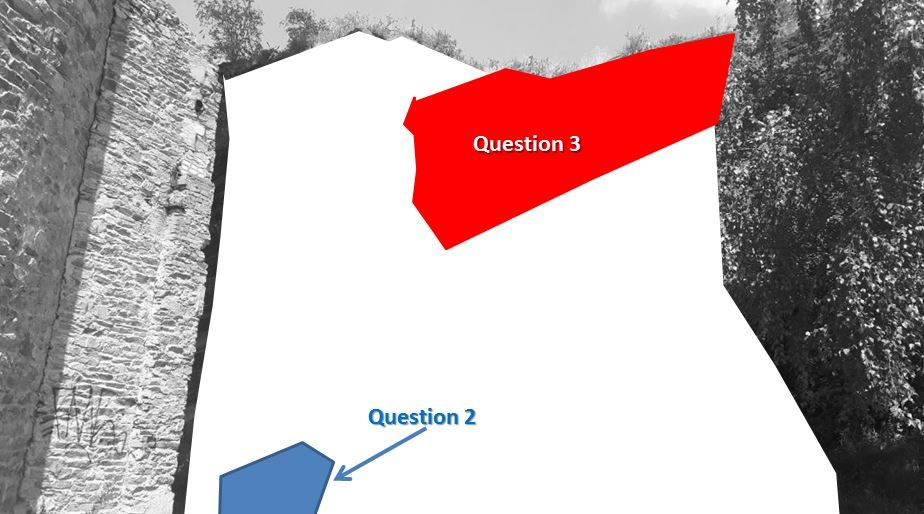
- Question 1 : Répondre aux questions suivantes pour déterminer la nature de la formation B de la carte géologique (zone en blanc sur la photo) : La roche est-elle grenue ? / Est-elle lisse ou rugueuse ? / Est-elle massive avec un débit en pavé ? / Présente t-elle un micro-litage ?
- Question 1 : Answer the following questions to determine the nature of formation B of the geological map (blank area in the photo): Is the rock grained? / Is it smooth or rough? Is it massive with paved flow? / Does she present a micro-bed?
- Question 2 : Observer au soleil (ou avec une lampe de poche s'il fait sombre) la zone bleue de la photo (base de l'affleurement au plus près du coin du bâtiment de la Tour à Plomb) ; qu'est-ce qui vous saute aux yeux et qu'est-ce qui est l'origine de ce phénomène ?
- Question 2 : Observe in the sun (or with a flashlight if it is dark) the blue area of the photo (base of the outcrop nearest the corner of the building of the Plummet); what are you jumping in the eyes and what is the origin of this phenomenon?
- Question 3 : Observer le haut de l'affleurement (zone rouge de la photo) ; quelle est sa coloration dominante, et quelle en est l'origine ?
- Question 3 : Observe the top of the outcrop (red area of the photo); what is its dominant coloring, and what is its origin?
Vous pouvez vous loguer sans attendre notre confirmation,
mais vous devez nous envoyer les réponses en même temps soit par mail via notre profil (
fafahakkai), soit via la messagerie geocaching.com (Message Center).
S'il y a des problèmes avec vos réponses nous vous en ferons part.
Les logs enregistrés sans réponses seront supprimés.Une photo de vous ou de votre GPS avec la Tour à Plomb en arrière plan (pas l'affleurement !) est la bienvenue, mais n'est pas obligatoire.
You can log this cache without waiting for our confirmation, but you must send us the answers at the same time, by e-mail via our profile (fafahakkai) or by the system of Message Center of geocaching.com.
If there is a problem with your answers we will notify you. The logs recorded without answers will be deleted.
A photo of you or your GPS with the Coueron Lead Tower in the background (not the outcrop!) Is welcome, but not mandatory.
Rappel concernant les « Earthcaches »: Il n'y a pas de conteneur à rechercher ni de logbook à renseigner. Il suffit de se rendre sur les lieux, de répondre aux questions ci-dessus et de nous renvoyer les réponses.
Reminder concerning "Earthcaches": there is neither a container to look for nor a logbook to sign. One need only go to the location, answer to the differents questions and send us the answers.