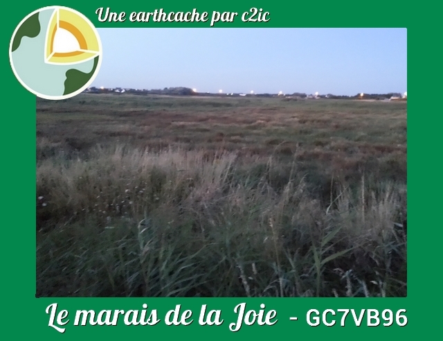
Autrefois, son nom était Silinou. Aujourd’hui on le désigne sous le nom de Marais de la Joie, en référence à la chapelle Notre-Dame-de-la-Joie qui longtemps, marqua sa limite Sud-Ouest. Ainsi, entre les deux affleurements rocheux de Saint Guénolé et de Saint Pierre, se trouve actuellement un palud auquel correspond un léger rentrant de la côte, et qui a succédé à un loc’h.
Formerly, his name was Silinou. Today it is referred to as the Marais de la Joie, in reference to the Notre-Dame-de-la-Joie chapel, which for a long time marked its southwestern limit. Thus, between the two rocky outcrops of Saint Guénolé and Saint Pierre, there is currently a salt which corresponds to a slight return from the coast, and which has succeeded to a loc'h.
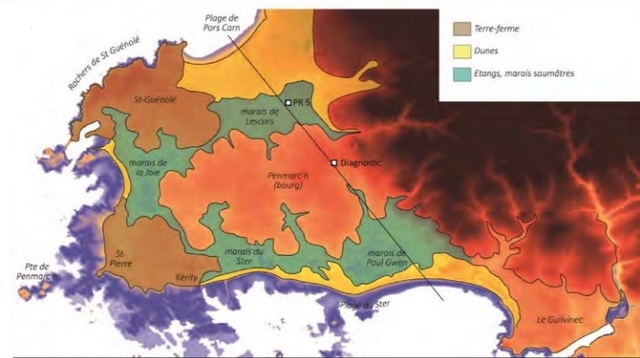
Celui-ci figure sur la carte de Cassini, sur celle de Beautemps-Beaupré (1818) et sur les vieilles éditions à l’échelle de 80 000ème. Il a été asséché au moyen d’une rigole et a cédé la place à des pâturages.
This one appears on the map of Cassini, on that of Beautemps-Beaupré (1818) and on the old editions on the scale of 80 000th. It was drained by means of a channel and gave way to pasture.

Evolution des paléo-environnements / Evolution of paleo-environments
Vers - 5000, le niveau de la mer se situe 6 à 7 mètres sous le niveau actuel. Bien que son niveau soit plus bas, la mer pénètre plus profondément dans l’intérieur des terres jusqu’à atteindre la base d’une ancienne falaise, désormais ensevelie sous le sable dunaire et que l’on retrouve à Pors Carn et à Tronoën plus d’un kilomètre en retrait du rivage actuel.
Devant cette falaise, les conditions à cette époque sont favorables à l’installation de slikkes sableuses et de schorres, protégés des vagues par des cordons littoraux.
Durant le Néolithique, la transgression marine se poursuit et favorise l’extension des marais, en bordure desquels on assiste à une mise en valeur agricole au Néolithique final et à l’âge du Bronze. Les massifs dunaires envahissent ces secteurs uniquement au début du 2nd âge du Fer (La Tène), vers - 400. Ces dunes bloquent l’écoulement des eaux vers la mer et favorisent le développement des premières tourbières dans le marais de La Joie.
Around - 5000, the sea level is 6 to 7 meters below the current level. Although its level is lower, the sea penetrates deeper inland until reaching the base of an ancient cliff, now buried under the sand dune and found in Pors Carn and Tronoën more one kilometer behind the current shoreline.
In front of this cliff, the conditions at that time are favorable to the installation of sandy slikkes and schorres, protected from the waves by littoral cords.
During the Neolithic, the marine transgression continues and promotes the extension of the marshes, on the edge of which there is an agricultural development in the late Neolithic and Bronze Age. The dune beds invade these areas only at the beginning of the 2nd Iron Age (La Tène), around - 400. These dunes block the flow of water towards the sea and favor the development of the first peat bogs in the marsh of La Joie.
Caractéristiques du sol / Soil characteristics
Cette zone humide est hydromorphe : Un sol est dit hydromorphe lorsqu'il montre des marques physiques d'une saturation régulière en eau, temporaire ou permanente. Parmi les zones hydromorphes, une coupe dans le sol ou un sondage à la tarière permet d'identifier une zone humide par les caractères pratiques suivants :
* Une couleur noire, sol pseudo-tourbeux, histosol, riches en matières organiques (feuilles mortes, autres végétaux morts, en décomposition lente). Ils connaissent un engorgement permanent en eau, pauvre en oxygène, qui retarde la décomposition des matières organiques.
* Des taches de couleur rouille de pseudo-gley, sol rédoxique ou rédoxisol, qui apparaissent dans les sols hydratés et oxygénés. Elles correspondent à du fer à l'état oxydé Le sol n'est pas saturé en eau en permanence mais les traces rouille subsistent en période sèche. La nappe phréatique remonte périodiquement et réhumidifie le sol.
* Des taches claires de couleur grise à gris-bleu ou gris-vert, de gley, sol réductique ou réductisol. Elles correspondent à du fer à l'état réduit. Le sol est saturé en eau et en condition anoxique (sans oxygène). On est dans un sol humide, dont l'humidité est entretenue par la présence d'une nappe phréatique proche.
This humid zone is hydromorphic: A soil is said to be hydromorphic when it shows physical marks of a regular saturation in water, temporary or permanent. Among the hydromorphic zones, a cut in the soil or an auger survey can identify a wetland by the following practical characteristics:
* A black color, pseudo-peat soil, histosol, rich in organic matter (dead leaves, other dead plants, in slow decomposition). They are permanently engorged in water, low in oxygen, which delays the decomposition of organic matter.
* Rust spots of pseudogley, redoxic soil or redoxisol, which appear in hydrated and oxygenated soils. They correspond to iron in the oxidized state The soil is not permanently saturated with water but the rust traces remain in the dry period. The groundwater rises periodically and remoistens the soil.
* Clear spots of gray to gray-blue or gray-green, gley, reductive soil or reductisol. They correspond to iron in the reduced state. The soil is saturated with water and in anoxic condition (without oxygen). It is in moist soil, the moisture is maintained by the presence of a nearby water table.
¨Pour valider cette earthcache / To validate this earthcache
Rendez-vous sur l'ancienne ligne de chemin de fer reliant Pont l'Abbé à Saint Guénolé jusqu'au coordonnées de cette earthcache - N 47° 48.635' W 4° 22.012' - puis descendez dans la zone humide (attention en hiver cela peut être très humide).
Là il ne vous reste plus qu'à observer le sol, éventuellement de le creuser légèrement afin de définir le type de sol : sol pseudo-tourbeux, histosol - sol rédoxique ou rédoxisol - sol réductique ou réductisol (aidez-vous de la couleur du sol et des informations ci-dessus pour trouver la réponse) !
Go to the old railway line connecting Pont l'Abbé to Saint Guénolé to the coordinates of this earthcache - N 47 ° 48.635 'W 4 ° 22.012' - then go down into the wet zone (be careful in winter it's can be very humid).
There you only have to observe the soil, possibly digging it slightly to define the soil type: pseudo-peat soil, histosol - redox soil or redoxisol - reductic soil or reductisol (help yourself with the color of the soil ground and information above to find the answer)!
Validez votre découverte / Validate your discovery
Loguez cette cache "Found it" et envoyez-moi vos réponses soit via mon profil, soit via la messagerie geocaching.com (Message Center), et je vous contacterai en cas de problème.
Log in this "Found it" cache and send me your answers either via my profile or via the geocaching.com (Message Center) mail, and I will contact you in case of a problem.
Pour rappel : il n'y a pas de boîte à trouver pour valider une earthcache ! Vous pouvez loguer votre découverte mais devez aussi m'envoyer vos réponses au plus vite.
To remind: there is no box to find to validate an earthcache! You can log your discovery but also send me your answers as soon as possible.