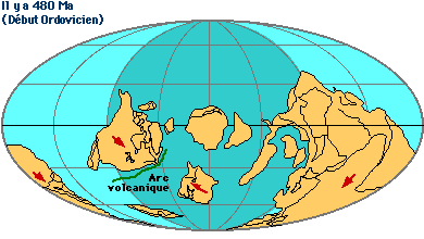
Localisé à la pointe extrême sud-ouest du massif Armoricain, le Pays bigouden est une petite partie d'une chaîne de montagnes hercynienne, formée entre 480 et 300 millions d'années avant notre ère, s'étendant alors de l'Amérique du Nord à l'Europe centrale, en passant par le Finistère.
Located at the extreme southwestern tip of the Armorican massif, Bigouden Country is a small part of a Hercynian mountain range, formed between 480 and 300 million years before our era, then extending from North America to Central Europe, passing through Finistère.
 |
 |
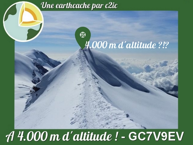
Cette chaîne est le résultat d'une collision entre deux masses continentales, Armorica et Gondwana, séparées par un océan. Elle a atteint plusieurs milliers de mètres d'altitude, jusqu'à 4 000 m, avant de s'éroder.
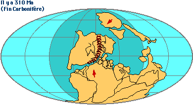
Le granit s'est refroidi, il y a 300 millions d'années, dans les profondeurs de cette chaîne. Une importante déformation a alors fracturé la roche dans la région de Saint-Guénolé avant que l'érosion ne lui donne ces formes spectaculaires.
This chain is the result of a collision between two landmasses, Armorica and Gondwana, separated by an ocean. It reached several thousand meters of altitude, up to 4000 m, before eroding. Granite cooled 300 million years ago in the depths of this chain. A major deformation then fractured the rock in the region of Saint-Guénolé before erosion gave it these spectacular forms.
Plus tard, il y a quelque 110 millions d'années, l'ouverture de l'océan Atlantique et la formation du golfe de Gascogne viendront disperser les restes de cette chaîne de montagne.
Later, some 110 million years ago, the opening of the Atlantic Ocean and the formation of the Bay of Biscay will disperse the remnants of this mountain range.
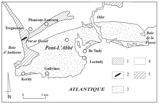
Aux alentours il est aujourd’hui possible de distinguer plusieurs unités géologiques :
- Au nord, affleurent les fragments disloqués et transformés de cet ancien océan (unités de Tréogat et de Peumerit), surmontés par les micaschistes de Penhors.
- Au sud, le granite de Pont l’Abbé, formé suite à l’épaississement de la croûte continentale et à sa fusion, s’est refroidi, il y a 300 millions d’années, dans les profondeurs de cette chaîne. Une importante déformation a alors fracturé le granite dans la région de Saint Guénolé avant que l’érosion ne lui donne des formes spectaculaires dont s’est emparée l’imagination populaire.
In the surroundings it is now possible to distinguish several geological units:
- To the north, the disjunct and transformed fragments of this ancient ocean (units of Tréogat and Peumerit), surmounted by micaschists of Penhors, are outcropping.
- In the south, the Pont l'Abbé granite, formed after the thickening of the continental crust and its melting, cooled down 300 million years ago in the depths of this chain. A major deformation then fractured the granite in the region of Saint Guénolé before the erosion gave it spectacular forms that took hold of the popular imagination.
Plus récemment, au cours du Quaternaire, des périodes de refroidissement intense alterneront avec des périodes interglaciaires plus clémentes et façonneront le paysage actuel.
More recently, during the Quaternary, periods of intense cooling will alternate with milder interglacial periods and shape the current landscape.
Questions
1 - Quels sont les noms des 2 masses continentales qui ont permis la création de la chaîne de montagnes hercynienne du pays Bigouden ?,
2 - Quelle différence d'altitude trouvez-vous entre l'altitude initiale de la chaîne hercynienne et l'altitude actuelle (4m; 40m; 400m ou 4000m) ?
1 - What are the names of the 2 continental masses that allowed the creation of the Hercynian mountain range of Bigouden country? ,
2 - What altitude difference do you find between the initial altitude of the Hercynian range and the current altitude (4m, 40m, 400m or 4000m)?
Validez votre découverte / Validate your discovery
Loguez cette cache "Found it" et envoyez-moi vos réponses soit via mon profil, soit via la messagerie geocaching.com (Message Center), et je vous contacterai en cas de problème.
Log in this "Found it" cache and send me your answers either via my profile or via the geocaching.com (Message Center) mail, and I will contact you in case of a problem.
Pour rappel : il n'y a pas de boîte à trouver pour valider une earthcache ! Vous pouvez loguer votre découverte mais devez aussi m'envoyer vos réponses au plus vite.
To remind: there is no box to find to validate an earthcache! You can log your discovery but also send me your answers as soon as possible.