Welcome to the Ghost Ranch! If you've just pulled up to the parking coordinates, you are at the Ghost Ranch visitor center. Kitchen mesa is directly to your North-East. Please make sure to sign in at the visitor center and let them know your destination. There is a $5.00 conservation fee payable at the Welcome Center that allows guest access to hiking trails, labyrinth, Museums, bathroom facilities and campus grounds. You can also get information about the hike here. Round trip distance to the top of the mesa is 3.7 miles with an elevation gain of 600 ft. Parts of the trail require rock scrambling and decent route-finding. Dogs are allowed but must be kept on a leash, and may have trouble with the rock scrambling portions. After a rain storm, the trail can become extremely muddy. Bring plenty of water and sun protection and enjoy the geology here! The Ghost Ranch staff also wants to remind all visitors to stay on marked paths and not to collect anything from the property.
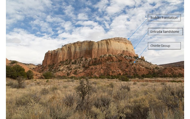
Geologic Layers of Kitchen Mesa
The breathtaking Kitchen mesa you see from the visitor center shows three distinct stratographic layers. As you start your hike up, stop at waypoint 1 (N36 19.944 W106 28.217) to read the geology information sign. This will provide some good context as you ascend the mesa. The lowest layer of the Kitchen mesa is from the Chinle Formation and contains sediments that were deposited 205 to 228 million years ago during the Triassic era. This layer is brick red to grayish green in color. The layer above this forms the beautiful sandstone walls of Kitchen mesa and is composed of Entrada Sandtone, deposited 165 to 180 million years ago in the Jurassic Age. The sediment in this layer was once part of a vast dune field that covered much of northern New Mexico. The top of kitchen mesa is a chalky white layer of the Todilto Formation which is a combination of gypsum and limestone and indicates that there was once a shallow sea or saline lake in the area. This formation is approximately 160 million years old. The Todilto Formation is the focus of this Earthcache but you will be hiking through the other two layers on your way up to this layer.
Todilto Formation Gypsum on Kitchen Mesa
Kitchen Mesa is one of the most breathtaking formations at the Ghost Ranch and part of what makes it so alluring is the chalky white layer that forms its top.... the icing on the cake so to speak. This layer is known as Todilto Formation and was formed in the Jurassic era by an incursion of shallow seas into the area. In the Chama Basin, the Todilto Formation consists of a lower limestone dominated interval referred to as the Luciano Mesa member and overlain locally by a gypsum layer known as the Tonque Arroyo Member. The Limestone member is typically thin measuring 2 to 8 meters thick and consists of dark grey or yellowish grey limestone and is found throughout the Chama basin. The white to light grey gypsum layer is up to 30 meters thick and has sporadic distribution in the basin. Where it is seen, it can be in convex upward mounds. It is thought that these mounds are the result of shallow brine pools that were left behind when the shallow sea that formed the Todilto formation began retreating.
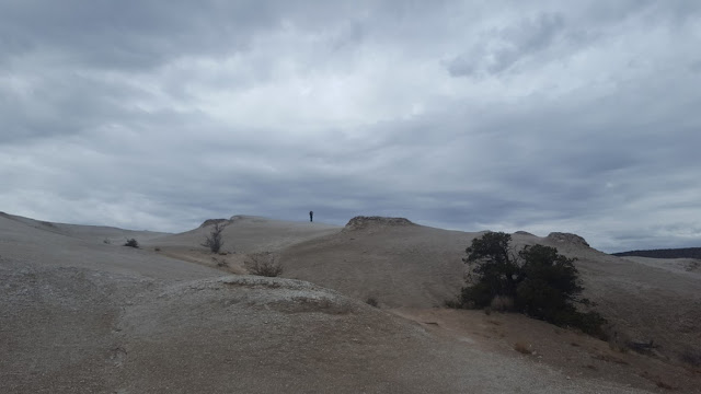
When you reach the posted coordinates for this Earthcache, you will be on the top of one of the Gypsum mounds of the Todilto Formation. It makes a surreal landscape, stretching out below you in each direction. Very little plant life has taken hold up here. Gypsum deposits such as the one you are standing on are formed when concentrations of calcium and sulfate in water are increased sufficiently to combine and form gypsum (CaSO4·2H2O). The inland sea or brine pond that was once in this location evaporated depositing the mineral layer you now see. Deposits of mineral sediments in this fashion are called Evaporites. When this occurs crystals can be formed and there are many types of gypsum crystals that have been found around the world. Look closely underfoot and you will find some small gypsum crystals (such as selenite). However, most of what you see around you is finely ground material, formed when the crystals are broken up. This material is called brecciated and is composed of mineral fragments cemented together by a fine-grained matrix.
Gypsum is a useful mineral to have around. It has been used since ancient times as an ingredient for plaster and is still used today as one of the main components of drywall. When it is heated, the water is driven from its crystal structure to produce anhydrite which is more commonly known as Plaster of Paris. Because of its moderate solubility in water which makes, it is often found in local water supplies where it contributes to water hardness. Indeed, if you live in the area, you well know that water hardness is an issue, leaving calcium build-ups on sinks and faucets. We owe some of this water hardness to the gypsum in our local environment.
Earthcache Tasks
In order to log this earthcache as found, send me your answers to the following questions.
- Describe the texture and appearance of the brecciated gypsum underneath your feet. Look for crystalline structures and impurities and make observations about how uniform the material over Kitchen mesa.
- By walking to different portions of the Todilto formation, make an estimated measurement of its thickness at the highest point. What does this thickness lead you to conclude about the formation of the layer here?
- Describe the hardness of the gypsum layer underfoot. If you so dare, taste the mineral and describe what you experience. How does this relate to the taste of hard water?
Sources
https://www.ghostranch.org/explore/the-land/
www.wikipedia.org (multiple citations for key-words)
Jurrasic stratigraphy in the Chama Basin, northern New Mexico; New Mexico Geological Society Fall Field Conference Guidebook - 56 Geology of the Chama Basin. Spencer G. Lucas, Adrian P. Hunt and Justin Spielmann, 2005, pp. 182-192. Downloaded from http://nmgs.nmt.edu/publications/guidebooks/56/
Economic Geology of the Todilto Formation, New Mexico Geological Society Guidebook, 54th Field Conference, Geology of the Zuni Pueblo, 2003, pp. 179-189. Website: https://nmgs.nmt.edu/publications/guidebooks/downloads/54/54_p0179_p0189.pdf
https://www.esci.umn.edu/courses/1001/minerals/gypsum.shtml