How many significant hurricanes have hit Boston over the last century? Answering that would be easy since the National Weather Service has been keeping records since 1891. But if the question instead was how many hurricanes have hit Boston over the last millennium, how would you possibly answer this? Well, that is why you have been brought to Lower Mystic Lake.
You have probably heard of scientist analyzing the annual rings of large trees to look back through the years and determine major events such as droughts or fires. Paleoclimatology is the study of climate changes using data that is preserved in rocks, sediments, ice, tree rings, corals, fossils.
But why were you brought here? Because Lower Mystic Lake is a very unusual lake being one of only 45 meromictic lakes known in the world as listed in Wikipedia in 2018. To understand a meromictic lake, let's first examine a typical lake (dimictic). In a typical lake, the upper and lower layers of the lake fully mix at least twice a year:
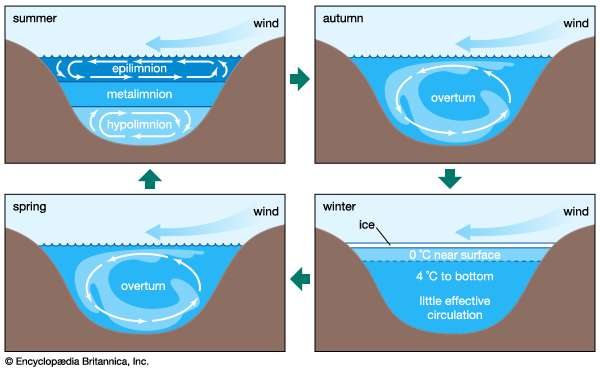
Typical Circulation in a Lake (from Encyclopædia Britannica)
Lower Mystic Lake is a meromictic lake in that the water never circulates from top to bottom. The lake is roughly three feet above sea level and before the Cradock Dam was built in 1908 between the lake and Boston Harbor, salt water would sometimes flow into the lake. Salt water being denser than fresh water would then sink to the bottom of the lake and is dense enough to prevent circulation with the upper level making it chemically stratified or meromictic.
With no circulation, the heavier salt water supported no life and allowed sediment to be layered undisturbed year after year. Similar to studying annual tree rings, scientists can analyze these layers and learn about climate over long periods of time.
In 2008, Mark Besonen and others published a paper entitled "A 1,000-year, annually-resolved record of hurricane activity from Boston, Massachusetts." In the paper, Besonen described taking core samples from the bottom of Lower Mystic Lake and analyzing the layers.
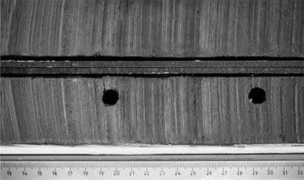
Core Samples from Lower Mystic Lake Taken by Mark Besonen and et al
A hurricane's very heavy rainfall and vegetation disturbance due to wind in the lake's watershed produced a larger, telltale layer. By going back a thousand layers, Besonen was able to chart Boston's hurricanes over the last millennium:
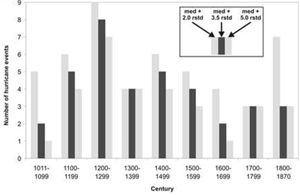
Boston Hurricanes by Century
And while you are at this spot, take a few minutes to look up. You might just see one of the lake's bald eagles.
To log this earthcache:
1) Estimate the height difference between the level of Lower Mystic Lake and the Upper Mystic Lake.
2) Look down while at ground zero. What is to your north and what is to your west?
3) Roughly 150 years ago, there was a significant change to the sediment. Look for a stone plaque on the ground for help. What was the cause of change to the sediment and what year did it happen?
4) Which century over the last millennium had the most hurricanes?
5) Optional: Take a photo of you standing in front of Lower Mystic Lake. While not required, it will prove you visited the location and there will be more leniency given towards your answers.
6) Bonus: Take a photo of one of the bald eagles that frequent the lakes.