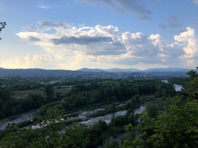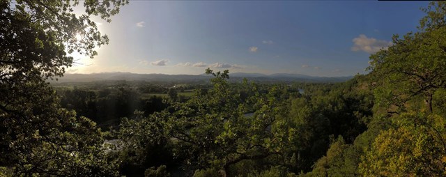
[FR] Un beau point de vue sur l'Ardèche (la rivière !) au premier plan, puis au second, en face de vous, Aubenas et son chateau.
Au fond, les contreforts des Cévennes et du Tanargue, avec :
- tout à gauche (à l'Ouest donc), le Mont Aigu (1316m) et la Cham du Cros,
- à gauche d'Aubenas, la montagne Sainte Marguerite (980m), reconnaissable à ces pylônes et émetteurs télé.
- derrière Aubenas, le Plateau ardèchois commence à se dessiner, puis en remontant au nord le rocher du Cheylard (1412m), le Serre de Berthy (809m), le Champ de Mars (1343m)...
- et tout à droite, légèrement derrière les arbres, on distingue le Roc de Gourdon (1061m) au dessus du col de l'Escrinet. En revenant vers l'ouest, juste à coté on voit le rocher de la Table (1002m) et juste à gauche, un truc pointu qui dépasse : c'est LE Truc, à 899m d'altitude sur la commune de Gourdon !
L'accès se fait par le village de Vogüé (chemin de Setras), parking possible au bout de la partie goudronnée. Après le chemin est carrossable, mais moins pratiquable (ne pas emprunter en voiture si vous avez peur de rayer titine !). A partir d'ici il vous reste un kilomètre à parcourir jusqu'à la boite (donc 2 AR).
Attention, après la cache, le chemin s’arrête là. Il y a un sentier qui descend au bord de l'eau, mais il est très escarpé et glissant.
L'aller-retour peut se faire à pied ou en VTT, mais la dernière partie est technique (single track en sous bois).
[EN] A beautiful point of view on the Ardèche (the river!) In the foreground, then the second, in front of you, Aubenas and its castle.
At the bottom, the foothills of the Cevennes and the Tanargue, with:
- all to the left (in the west therefore), the Mount Aigu (1316m) and the Cham du Cros,
- to the left of Aubenas, the Sainte Marguerite mountain (980m), recognizable by these pylons and TV transmitters.
- behind Aubenas, the Plateau Ardèchois begins to take shape, then going up north the rock of Cheylard (1412m), Serre de Berthy (809m), the Champ de Mars (1343m) ...
- and to the right, slightly behind the trees, we can see the Roc de Gourdon (1061m) above the Col de l'Escrinet. Returning to the west, just next to the rock table (1002m) and just left, something sharp beyond: it's LE Truc, 899m above sea level in the town of Gourdon!
Access is from the village of Vogüé (Setras road), parking possible at the end of the tarmac (WP1). From here it's more complicated by car and it's only one kilometer long to go to the little box.
Be careful, after the cache, the path stops there. There is a path down to the edge of the water, but it is very steep and slippery.
The round trip can be done on foot or mountain bike, but the last part is technical (single track in the woods).