If you’ve done an earthcache along Lake Michgan you may already know the story: glaciers moved, debris moved, glaciers retreated, Lake Michigan and the dunes are left. While the process sounds simple, the results are astounding. Perhaps because we are so used to the grandeur of Lake Michigan it no longer seems as impressive. Instead of awe at the beauty of the dunes, we see big piles of sand.
Lake Michigan and the Indiana Dunes are amazing and while some of us are lucky enough to see them frequently, they were not always here. It took time for them to form and the area is still changing today.
As geologist studied the lake and dunes, there were many hypotheses as to how these features formed. The general consensus today is that glaciers moved down from the north and carved out what is now Lake Michigan and deposited a lot of debris at the southern end of the glacier, and as the glaciers retreated. This did not happen in a matter of days, but over several thousands of years. It is believed that the glacier would pull-back, then move forward again, and then pull-back over and over again. Carving and depositing as it went.
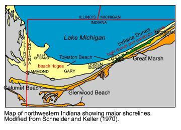
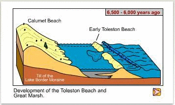
As you look at the landscape from the posted coordinates you can see why this theory has gained wide acceptance. Look to the south of where you are standing. You’ll see in the distance a ridge that runs east-west. This ridge is known as the Calumet Beach. About 11,800 years ago the glacier re-advanced into the area. Water that had flowed into the basin from rivers was pushed south as the glacier re-advanced and sediment was moved along with it. This sediment accumulated by the work of wind and waves into the Calumet Beach (the yellow area in the image below).
Eventually, the glaciers retreated once again. The levels of ancient Lake Michigan were actually quite low at this time. Then the water level began to rise and as the water rose a new barrier beach formed. This barrier beach formed a bit further north of where you are standing, but moved landward by storms. Overtime, the sand accumulated and what is now called the Toleston Beach formed. The dune you are standing on is part of the Toleston Beach, which is still forming today by wind and waves moving sand.
The interesting part of this is that the Calumet Beach and Toleston Beach are quite far apart. In some areas they are so far apart that you cannot see one from the other (several miles). Lucky for you, you can see the Calumet Beach from where you are standing. In between the Calumet Beach and the Toleston Beach is the Great Marsh. As the Toleston Beach formed, so did the Great Marsh. Visit GC18BHE to learn about the Great Marsh.
My hope is that with this earthcache you have learned something new, but also that you can enjoy this area a little bit more after thinking about how it formed and what it took to create these dunes and Lake Michigan. It really is a remarkable landscape.
In order to log this Earthcache...
Please read the following questions and send me your answers.
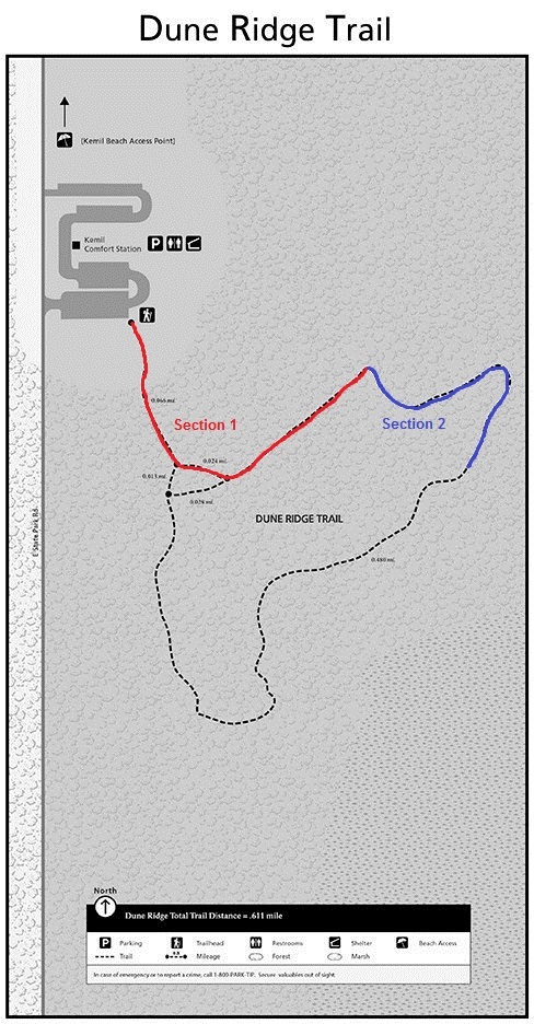
- There are two sections of this trail that I would like you to compare. Section 1 is from the parking lot to the Trail Turnoff Waypoint. Section 2 is from the Trail Turnoff Waypoint to the Posted Coordinates. What is the makeup of the trail on these two sections? What is the topography like for these two sections? Is it similar or different?
- Look south/southeast. You should see two cell towers out on the ridge. The ridge with those two cell towers is the Calumet Beach, the furthest shoreline of ancient Lake Michigan. How far would you guess is that ridge from where you are standing? Is the Calumet Beach ridge around the same height as the Toleston Beach ridge that you are standing on?
- Please post a picture of you or a signature item at the posted coordinates.
Sources:
https://igws.indiana.edu/FossilsAndTime/LakeMichigan.cfm
| I have earned GSA's highest level: |
 |
Thanks to the Indiana Dunes National Lakeshore for permission to place this cache