Vue sur Semur en Auxois et la Terre Plaine
Origine
La ville se situe dans la plus vaste des 4 vallées formant le pays d'Auxois, au carrefour des contreforts du Morvan, des plaines du Châtillonnais et des abords de l'Autunois.
Lieu d'habitation séculaire, la légende raconte que Semur fut bâtie par Hercule lors de son retour d'Espagne.
C'est en 1606 dans la charte de fondation de l'abbaye de Flavigny que l'on trouve la première trace écrite de Semur, nommée alors « sene muro » : vieilles murailles soulignant ainsi le caractère défensif et ancestral du site.
Situation régionale
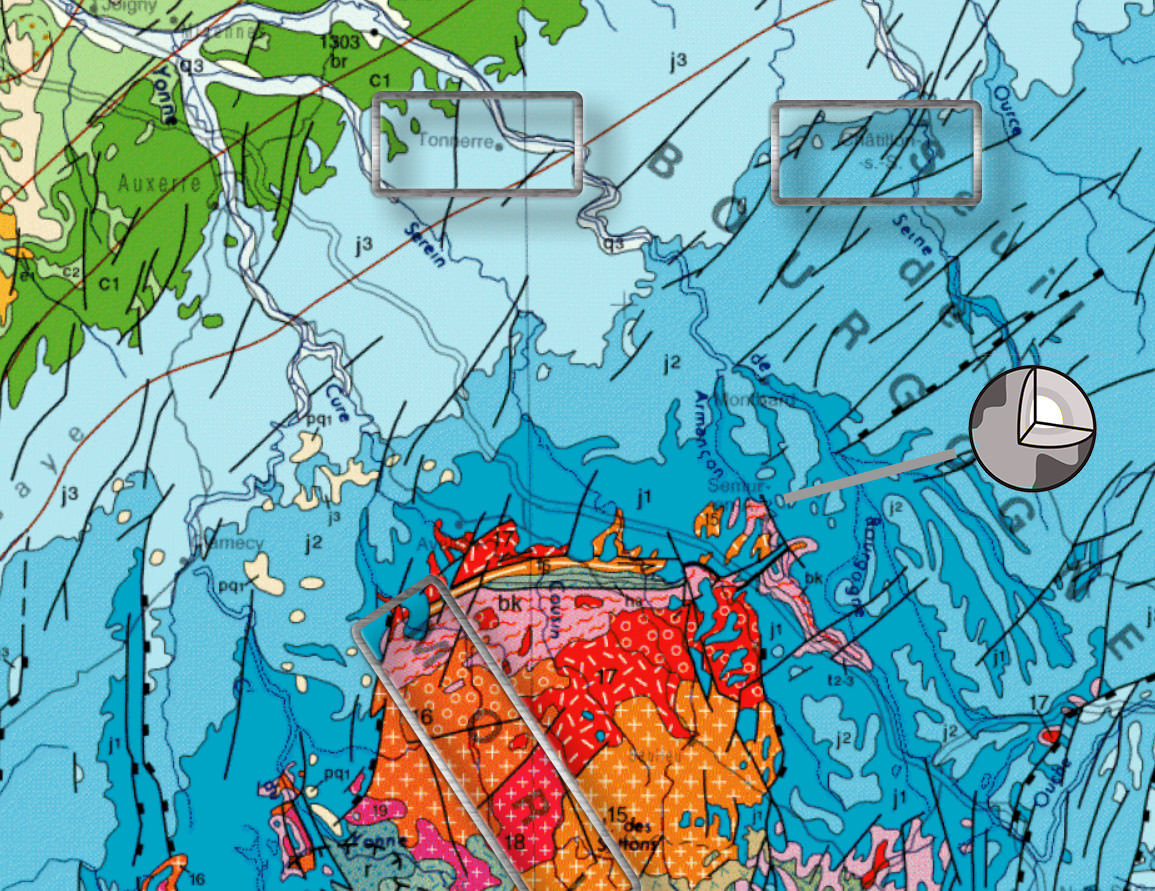
Le territoire de Semur-en-Auxois est situé à la jonction de deux configurations géomorphologiques distinctes, à savoir les plateaux calcaires du Tonnerrois et du Châtillonnais et les massifs éruptifs du Morvan, entre lesquels se glisse la dépression de la Terre-Plaine.
Situation locale
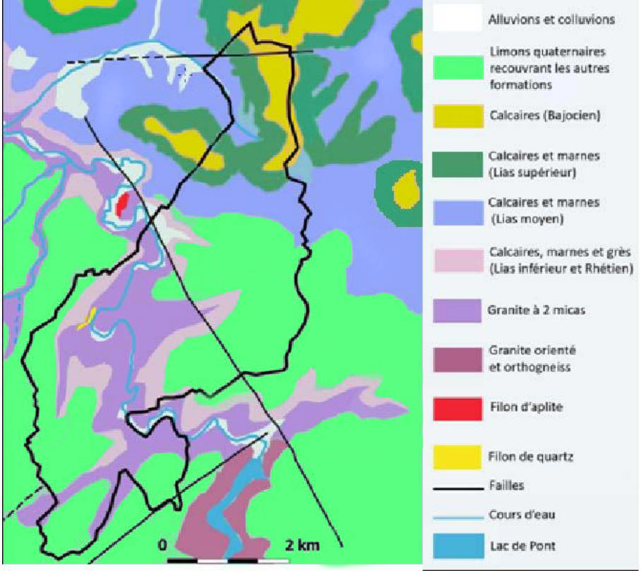
La structure géologique est essentiellement calcaire.
Cette assise est profonde au Nord de l’agglomération. Ce calcaire s’est plus ou moins altéré vers un sol marneux. De ce fait, la partie Nord du territoire est une succession de couches de calcaire et de couches de calcaire marneux, voire de marne. Les marnes étant des matériaux imperméables, à l’affleurement de ces couches, des lignes de résurgence des eaux d’infiltration engendrent des terrains humides propices aux prés et donc favorables à l’élevage.
Les buttes, au Nord, sont couronnées de calcaires « à entroques ».
Au Sud de l’agglomération le calcaire s’amenuise pour ne faire que recouvrir le socle granitique du Morvan. Cette roche éruptive a localement émergé de l’assise calcaire.
L’érosion de l’Armançon a dégradé le calcaire, mettant à découvert une roche granitique (granit rose) très dure qui constitue l’éperon rocheux sur lequel est implantée la ville.
Cette caractéristique géomorphologique est très importante car c’est elle qui a défini le relief, et c’est à son tour le relief qui a déterminé la forme urbaine (dans le méandre et les rebords de plateau)
EN View of Semur en Auxois and Terre Plaine
Origin

The city is located in the largest of the 4 valleys forming the Auxois country, at the crossroads of the foothills of the Morvan, the plains of Châtillonnais and the outskirts of the Autunois.
A secular place of habitation, legend has it that Semur was built by Hercules on his return from Spain.

It is in 1606 in the charter of foundation of the abbey of Flavigny that one finds the first written trace of Semur, then called "sene muro": old walls thus emphasizing the defensive and ancestral character of the site.


Regional situation


The territory of Semur-en-Auxois is located at the junction of two distinct geomorphological configurations, namely the limestone plateaux of Tonnerrois and Châtillonnais and the eruptive massifs of the Morvan, between which the depression of the Terre-Plaine slips.


Local situation


The geological structure is essentially limestone.

This seat is deep north of the agglomeration. This limestone has more or less altered to a marly soil. As a result, the northern part of the territory is a succession of layers of limestone and layers of marly limestone, even marl. Marls being impervious materials, at the outcrop of these layers, lines of resurgence of seepage water generate wet lands favorable to the meadows and thus favorable to the breeding.

The mounds, in the North, are crowned with limestones "with entroques".

South of the agglomeration the limestone diminishes to only cover the granitic base of the Morvan. This eruptive rock has locally emerged from the calcareous bedrock.

The erosion of the Armançon has degraded the limestone, exposing a very hard granitic rock (pink granite) which constitutes the rocky outcrop on which the city is located.

This geomorphological feature is very important because it is the one that defined the relief, and it is in turn the relief that determined the urban form (in the meander and the shelf edges)
Rappel concernant les « Earthcaches »: Il n'y a pas de conteneur à rechercher ni de logbook à renseigner. Il suffit de se rendre sur les lieux et d'éxécuter les requêtes du geocacheur.
Loguez cette cache "Found it" et envoyez-moi vos propositions de réponses soit via mon profil, soit via la messagerie geocaching.com (Message Center), EN PRECISANT LE NOM ET CODE GC DE LA CACHE et je vous contacterai en cas de problème.
Il est aussi apprécié d'avoir des photos des géocacheurs sur les lieux de l''EarthCache. Sentez vous inspiré de poster des photos de vous lors de cette visite ( optionnelle mais sympathique)
---
Reminder concerning "Earthcaches": there is neither a container to look for nor a logbook to sign.
Log in this cache " Found it " and send me your answers proposals or via my profile or via geocaching.com messaging (Message Center ) , BY PROVIDING THE NAME AND GC CODE OF THE CACHE and I will contact you in case of problems .
We also enjoy seeing photographs of people visiting this EarthCache. Please feel free to log photos of your visit...(this is entirely optional but funny)
Grace à la lecture attentive du descriptif et votre observation, répondez aux questions suivantes :
Thanks to the reading with attention of the description and your observation, answer the following questions:
Grace à la lecture du descriptif et votre observation, répondez aux questions suivantes :
Thanks to the reading of the description and your observation, answer the following questions:
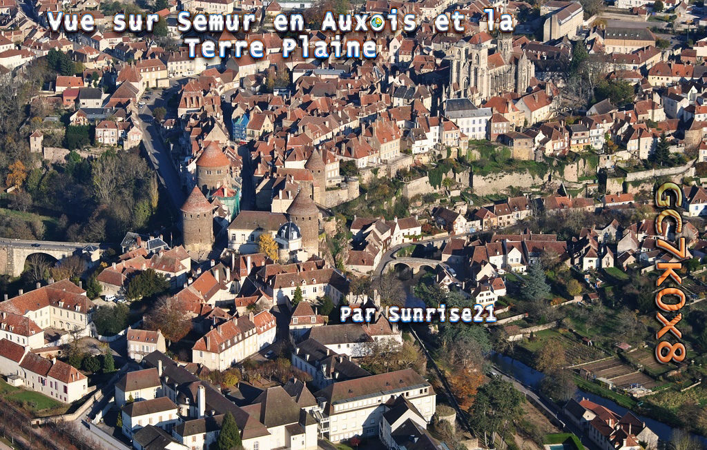
FR En regardant vers Semur,
Q1)
a)Au premier plan quelle partie de la ville voit on ?
b) Sur quelle typologie de sol est elle construit ?
c) Déduisez en le rôle de l’Armancon sur la formation de cette partie de la ville.
d) A contrario, quel element geologique explique que la Collegiale et les Remparts soient surelevés?
Q2)
a)Que voyez-vous au second plan ?
b) Sur cet élément du second plan, combien de couche (que vous me situerez) pouvez vous distinguer ?
EN Looking towards Semur,
Q1)
a)-In the foreground what part of the city does one see?
b) What type of soil is it built on?
c) Decide in the role of Armancon on the formation of this part of the city.
d) On the other hand, what geological element explains that the Collegiale and the Remparts are raised?
Q2)
a) What do you see in the background?
b) On this element of the second plane how many layer (which you will locate me) can you distinguish?
JOYEUX & HAPPY EARTHCACHING