
The Maryland Geocaching Society welcomes you to the 2018 edition of Cache Across Maryland! This is one of eleven geocaches placed throughout the "Old Line State" in locations chosen to showcase Maryland's diverse beauty. From the mountains of Western Maryland to the Atlantic Ocean, Cache Across Maryland 2018 will once again demonstrate that Maryland truly is “America in Miniature”.
Each geocache contains a code which you will use to determine the location of the CAM 2018 Picnic to be held on May 5th, 2018. The code can be found on the inside of the cache container and on the inside front cover of the logbook. Don't forget to record this code! Any geocacher who has completed at least TEN of the eleven CAM geocaches and attends the CAM Picnic on May 5th will receive a Certificate of Completion and a Cache Across Maryland 2018 Geocoin in Antique Silver. We hope you enjoy CAM 2018!
Upper Youghiogheny River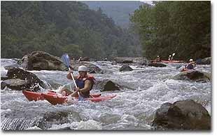
The Youghiogheny River (pronounced yock’-a-gain’ ee) is part of the immense Mississippi River watershed, which stretches from the western slopes of the Appalachian Mountains in the east, to the eastern side of the Rocky Mountains in the west. The name Youghiogheny is a Lenape word meaning "a stream flowing in a contrary direction", given because the river flows primarily north. The Yough's headwaters are found in Preston County, West Virginia, not far from Maryland's highest point at Hoye Crest on Backbone Mountain. The river flows through Silver Lake, then into the rolling farmlands of southern Garrett County, Maryland, where it cuts a northward path through some of the most rugged mountain scenery in Maryland before flowing into Pennsylvania and merging with the Monongahela River at McKeesport, southeast of Pittsburgh. A dam at Confluence, PA creates Youghiogheny River Lake, which nearly reaches Friendsville. Further downstream near Ohiopyle, in Pennsylvania's Laurel Highlands, you can find two of Frank Lloyd Wright's most famous homes - Fallingwater and Kentuck Knob - nearby.
In 1976, a 21-mile stretch of this river was designated as Maryland’s first Wild River. A State-protected corridor runs from Miller’s Run, just north of Oakland, to the town of Friendsville. Along the way, the river passes through Swallow Falls, Hoyes Run, and Gap Falls, and is fed by Deep Creek Lake as it passes to the west. From Swallow Falls to Hoyes Run, the river drops 280 feet in elevation over 4 miles of falls and rapids. From Gap Falls to Friendsville, over some of the wildest and most rugged sections of the river, it drops elevation an average of 100 feet per mile.

During the late 1800s, Garrett County grew in an economy based on agriculture, timber and coal. The arrival of the B&O Railroad to the area after the Civil War opened natural resources to large-scale harvest and development. The railroad not only provided transportation for people, but offered a means to move timber out of Garrett County to the east, since it couldn’t be floated downstream over the falls and cataracts. This, in turn, allowed the exploitation of timber and coal reserves. In the nearby small town of Kendall (about 2 miles south of the trailhead), the A. Knabb Company made barrels and staves from the native white oak, while the Kendall Lumber Company operated a large sawmill that shipped 3.5 million board feet of timber per day at its peak. But it wasn’t long before the forests were depleted and the local economy began to fail. The lumber business was thriving in 1908, but by 1912, the Kendall Lumber Company ceased operations, and little remains of the town of Kendall today.
Since then, the land has regenerated by natural process and the help of many landowners throughout the valley. The Maryland Department of Natural Resources is actively acquiring land throughout the valley to preserve the beauty of this area for future generations. The Maryland Park Service bought an 81-acre tract called Friend’s Delight in 2008. This tract was originally settled by John Friend after bartering with the Shawnee tribe.
Friendsville, named for John Friend, was settled in 1765. This area was a gathering place for Native Americans for the past 3500 years. Archaeological digs, prompted by construction of Interstate 68 in the late 20th century, have revealed 49,000 artifacts from the most recent Shawnee Village. Various tools and artifacts from pre-Columbian cultures such as the Adena Mound Builders (ca. 800 B.C.) and Hopewell Culture have also been unearthed.

Kendall Trail is a short trail running south along the Yough out of Friendsville. It follows the bed of an 1890's era railroad that lead to the old logging community of Kendall (originally known as Krug for it's founder). Kendall was the southern terminus of the Confluence and Oakland Railroad and the beginning of the Krug Lumber railroad that had narrow-gauge rail lines extending throughout the Youghiogheny Valley.
Most of the river corridor runs through private landholdings, so all precaution should be used to avoid trespassing. The Kendall Trail, which you will be walking for this cache, is a public access area. Leashed dogs and bicycles are allowed along this trail. Other nearby activities include whitewater boating, fishing and hunting. Please be respectful of the area.
The Geocache
This geocache is located at the listed coordinates.
You will find the Kendall Trailhead .2 mile from suggested parking coordinates. Do not park in private residential areas near the trailhead - use the given Parking coordinates only. As you leave the parking lot on foot, follow the marked pedestrian trail that goes behind the white "house" (it's a small store with upstairs apartment), then cross the bridge over the river. Continue on Maple Street to Morris Avenue and turn right. The trailhead is the dirt path that forks from the pavement just past the Civil War-era fencing. Follow this trail to the cache. The trail follows the riverbed on the east side of the Youghiogheny River.
The trail is open from dawn to dusk. Bicycles and leashed dogs are allowed.
This geocache was placed by permission of Maryland DNR Deep Creek Recreation Area. The MGS extends its thanks to the Maryland Department of Natural Resources for approving this cache placement.