
La Earthcache / The Earthcache
Nantes a eu la chance de voir naître un des plus célèbres auteurs de romans d'anticipation, Jules Verne ; celui-ci a notamment fait descendre ses personnes au cœur de la croûte terrestre dans "Voyage au centre de la Terre".

Mais savait-il seulement que juste sous ses pieds, sur les hauteurs de la Butte Sainte-Anne, se trouve une roche née et ayant grandi au "Centre" de la Terre (ou plutôt depuis les profondeurs de la couche terrestre) ?
► Contexte géologique local
La Butte Sainte-Anne forme un éperon rocheux au dessous de la Loire et des zones plus basses de l'agglomération nantaise.
Que nous dit la carte géologique sur cette zone ?

Celle-ci nous apprend que la Butte Sainte-Anne est constituée par le massif granitique d'Orvault-Mortagne, un granite à deux micas orienté.
Cet immense batholite orientée N 120° appartient au Domaine varisque nantais et est limité sur son flanc sud par le Cisaillement sud-armoricain (CSA), grand accident transcurrent, initié lors de la collision continentale finivarisque (Carbonifère), qui se suit depuis le Finistère (Pointe du Raz) à l'Ouest jusqu'aux Deux-Sèvres à l'Est.
Si la zone ouest de ce batholite présente une déformation du granite du fait de ce cisaillement avec un processus de mylonitisation, la partie Est est plus anatectique, mais a tout de même subit les conséquences des mouvements tectoniques.
Ce granite est locale connue pour être une très bonne pierre de construction, et a été intensivement exploité depuis le XVème siècle dans la carrière de la Miséri voisine pour la fabrication du célèbre pavé nantais, donnant des pavés de rues et des pierres de construction.
► Naissance du granite de la Butte Saint Anne
Le granite à deux micas, comme toutes roches magmatiques plutoniques, a vu le jour dans les entrailles de la Terre, à la limite entre la croûte terrestre et la partie supérieure du manteau (les deux formant la lithosphère).
La roche magmatique en fusion remonte du manteau sous la forme de plutons à l'occasion de mouvement tectoniques, comme l'orogenèse de chaînes montagneuses.

Le magma liquide va alors progressivement se cristalliser au fur et à mesure qu'il pénètre dans la croûte terrestre et que la température baisse.
Cette cristallisation peut avoir une vitesse variable selon la vitesse de remontée et de refroidissement.
Plus le refroidissement est lent, plus les cristaux formés sont gros (on parle alors de phénocristaux, d'une taille supérieure à 1 cm et le granite est qualifié de porphyroïde).
Et c'est exactement ce qui s'est passé pour notre granite de la Butte Saint Anne.
Il y a 300 millions d'années les mouvements tectoniques au sein de la Pangée provoque l'orogenèse hercynienne, une chaîne de montagne plus haute que l'Himalaya situé au niveau de l'actuel Massif Armoricain. Au coeur de cette chaîne, des plutons se cristallisent vers la fin de cet épisode varisque pour former le granite à deux micas.
Ce granite à grain moyen est typique des pointements granitiques qui jalonnent le sud de la Bretagne.
C'est un granite alcalin leucocrate, très voisin de celui de Vigneux-Orvault mais à grain moins grossier.
Il est principalement composé de minéraux de :
- quartz, minéral dur de couleur gris d'aspect mat et translucide
- feldspath, de couleur blanc laiteux d'aspect brillant
- biotite, un petit mica noir brillant
- muscovite, un mica plus grand de couleur blanc brillant

► Une adolescence mouvementée
En fin de cristallisation, ce granite a subit des bouleversements qui l'ont marqué durablement.
Ainsi, localement, ce granite est recoupé par des diaclases et des filons de pegmatite.
D'ou viennnent ces structures ?
A la fin de sa formation, la roche devenue solide et très rigide subit de plein fouet les pressions tectoniques.
Cassante, elle se pare de nombreuses fissures présentant souvent des angles droits, les diaclases.
En parallèle, ces fissures peuvent se remplir de fluides résiduels non encore cristalisés. Leur solidification, qui se réalise très lentement du fait de la présence d'eau, va provoquer l'apparition de gros cristaux et donner une roche à gros cristaux nommée pegmatite, composé d'un mélange de quartz (majoritaire) et d'autres minéraux plus rares à cristalisation tardive.

Nantes was lucky to see the birth of one of Jules Verne's most famous authors of anticipatory novels; this particular has made his people descend to the heart of the earth's crust in "Journey to the center of the Earth".
But did he know that just under his feet, on the heights of Butte Sainte-Anne, is a rock that made the opposite trip; The trip from the "Center" of the Earth (or rather from the depths of the Earth's layer) to the Butte de Sainte Anne.
► Local geological context
The Butte Sainte-Anne forms a rocky outcrop below the Loire and lower areas of the Nantes agglomeration.
What do the geological map tell us about this area?
This one tells us that the Butte Sainte-Anne is constituted by the massive granite of Orvault-Mortagne, a granite with two micas oriented.
This immense batholith, oriented N 120 ° belongs to the Varisque Domain of Nantes and is limited on its southern flank by the South-Armorican Shear (CSA), great transcurrent accident, initiated during the continental finivarisque collision (Carbonifère), which follows from Finistère (Pointe du Raz) in the West to Deux-Sèvres in the East.
If the western zone of this batholith exhibits deformation of the granite due to this shear with a process of mylonitization, the eastern part is more anatectic, but still suffered the consequences of the tectonic movements.
This granite is local known for being a very good building stone, and has been extensively exploited since the 15th century in the quarry of the neighboring Miséri for the manufacture of the famous pavement of Nantes, giving street pavers and building stones.
► Birth of the Saint Anne's granite
The two-mica granite, like all igneous plutonic rocks, was born in the bowels of the Earth, at the boundary between the crust and the upper mantle (both forming the lithosphere).
The molten magma rock rises from the mantle in the form of plutons on the occasion of tectonic movements, such as the orogeny of mountain ranges.
The liquid magma will gradually crystallize as it enters the earth's crust and the temperature drops.
This crystallization can have a variable speed depending on the rate of rise and cooling.
More cooling is slower, the crystals formed are large (called phenocrysts, larger than 1 cm and granite is called porphyritic).
And that's exactly what happened to our granite from Butte Saint Anne.
There are 300 million years tectonic movements within Pangea causes the Hercynian orogeny, a mountain chain that Himalayan located at the current Armorican Massif. At the heart of this chain, plutons crystallize towards the end of this Variscan episode to form the granite with two micas.
This medium-grained granite is typical of the granitic points that mark the south of Brittany.
It is a leucocratic alkaline granite, very close to that of Vigneux-Orvault but with a coarser grain.
It is mainly composed of minerals of:
- quartz, hard gray mineral of matt and translucent appearance
- feldspar, milky white in appearance
- biotite, a glossy black mica
- muscovite, a larger mica of bright white color
► A hectic adolescence
At the end of crystallization, this granite has undergone upheavals that have marked durably.
Thus, locally, this granite is intersected by diaclases and veins of pegmatite.
Where do these structures come from?
At the end of its formation, the rock became solid and very rigid undergoes full whip the tectonic pressures.
Cassante, it is adorned with many cracks often with right angles, joints.
In parallel, these cracks can be filled with residual fluids not yet crystallized. Their solidification, which is carried out very slowly due to the presence of water, will cause the appearance of large crystals and give a large crystal rock called pegmatite, composed of a mixture of quartz (majority) and other minerals more rare to late crystallization.
► Sources bibliographiques / Bibliographical sources
Les Questions / The Questions
La lecture attentive du descriptif de la cache, ainsi qu'une observation des éléments de terrain et un peu de déduction sont normalement suffisants pour répondre aux questions de cette EarthCache.
Une lampe pourra aussi vous être utile en l'absence de soleil.
A careful reading of the description of the cache, as well as observation of terrain features and some deduction is usually sufficient to answer questions of this EarthCache.
A lamp can also be useful in the absence of sun.
Questions pour valider :"Naissance au Centre de la Terre"
Questions to validate: "Formation in the Center of the Earth"
Point 1 : N 47° 12.140 W 001° 34.613
Depuis le trottoir, prenez sur quelques mètres l'escalier jusqu'à la zone sur votre droite ou se trouve le cercle bleu (photo WP1).
From the sidewalk, take a few steps up the stairs to the area on your right where is the blue circle (photo WP1).
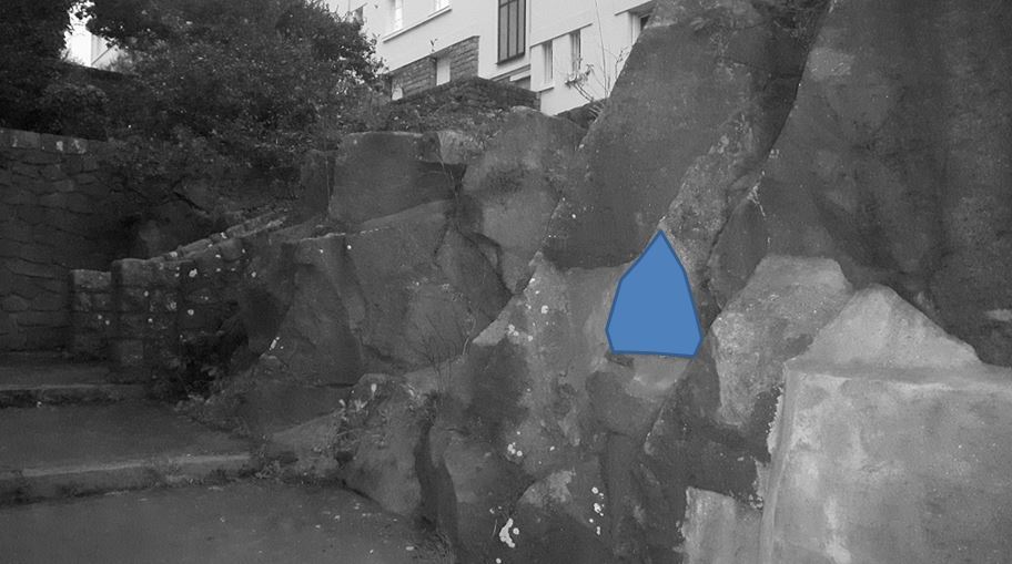
- Question 1 : Observer l'affleurement et évaluez la taille moyenne des cristaux formant la roche sous la zone bleue. Peut-on qualifier cette roche de porphyroïde ?
-
Question 1 : Observe the outcrop and evaluate the average size of the crystals forming the rock below the blue zone. Can we call this porphyroid rock?
- Question 2 : S'il n'y a pas de soleil, éclairez la roche avec une lampe. Qu'est ce qui vous saute aux yeux ? De quoi s'agit-il ?
- Question 2 : If there is no sun, illuminate the rock with a lamp. What catches your eye? What is it about ?
Point 2 : N 47° 12.137 W 001° 34.589
Traverser (avec prudence) la route jusqu'à l'esplanade. Une statue représentant le capitaine Nemo, célèbre personnage de Jules Verne, s'y trouve.
Cross (with caution) the road to the esplanade. A statue of Captain Nemo, famous character of Jules Verne, is there.
- Question 3 : Décrivez la roche formant le piédestal de la statue du capitaine Nemo. D'après vos observations et celles du WP précédent, pensez-vous que ce bloc ait pu être extrait d'une carrière se trouvant sur cette formation géologique ?
- Question 3 : Describe the rock forming the pedestal of Captain Nemo's statue. Based on your observations and those of the previous WP, do you think that this block could be extracted from a quarry located on this geological formation?
Point 3 : N 47° 12.131 W 001° 34.593
Vous voici devant un affleurement de roche juste avant la falaise (voir photo WP3).
Here you are in front of an outcrop of rock just before the cliff (see photo WP3).
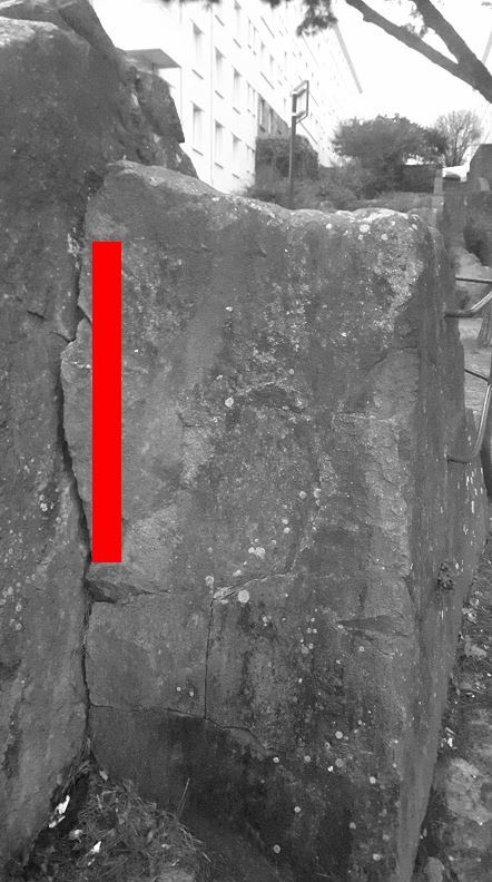
- Question 4 : Que voyez vous sous la zone rouge ? Quelle est sa largeur ?
- Question 4 : What do you see under the red zone? What is its width?
Vous pouvez vous loguer sans attendre notre confirmation,
mais vous devez nous envoyer les réponses en même temps soit par mail via notre profil (
fafahakkai), soit via la messagerie geocaching.com (Message Center).
S'il y a des problèmes avec vos réponses nous vous en ferons part.
Les logs enregistrés sans réponses seront supprimés.Une photo de vous ou de votre GPS avec la vue de l'île Beaulieu et les anneaux de Buren depuis l'esplanade des statues est la bienvenue, mais n'est pas obligatoire.
You can log this cache without waiting for our confirmation, but you must send us the answers at the same time, by e-mail via our profile (fafahakkai) or by the system of Message Center of geocaching.com.
If there is a problem with your answers we will notify you. The logs recorded without answers will be deleted.
A photo of you or your GPS with the view of Beaulieu Island and the Buren rings from the esplanade of the statues is welcome, but not mandatory.
Rappel concernant les « Earthcaches »: Il n'y a pas de conteneur à rechercher ni de logbook à renseigner. Il suffit de se rendre sur les lieux, de répondre aux questions ci-dessus et de nous renvoyer les réponses.
Reminder concerning "Earthcaches": there is neither a container to look for nor a logbook to sign. One need only go to the location, answer to the differents questions and send us the answers.