| I have earned GSA's highest level: |
 |

Debes caminar por la playa para reclamar este caché! No puede completar los requisitos de registro de un barco en el agua.
Este earthcache es sobre el tafoni de Lands End, al sureste de Cabo San Lucas. No se puede llegar hasta aquí caminando; sólo se puede acceder en barco. Si te interesa, se puede conseguir un viaje en taxi acuático que sale muy económico en el puerto deportivo. Una vez allí, habrá que buscar esta roca en medio del pasillo de la playa para comenzar este caché. 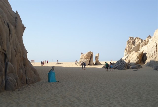
Tafone (tafoni, en plural) es una cavidad de roca natural elipsoidal, con forma de cuenco. Estas características de meteorización cavernosa incluyen pozos pequeños, cavidades del tamaño de una pelota de softball, cuevas del tamaño de un camión y formas de nido de abeja anidadas y celulares. Los tafoni generalmente se desarrollan en superficies inclinadas o verticales, y aparecen en grupos. Estas exquisitas y fascinantes formas de meteorización cavernosas están presentes en las superficies de muchos tipos diferentes de rocas ubicadas en una multitud de regiones geográficas de todo el mundo. Desde finales de 1800, se han publicado más de 100 artículos de investigación en numerosos idiomas sobre este tema geomórfico. El desarrollo y evolución del Tafoni es desconcertante y continúa despertando curiosidad.
¿Cómo se forma los Tafoni? Se han presentado varias teorías para explicar la formación de tafonatos, que incluyen: congelación-descongelación, humectación-secado, erosión salina, intratidal, así como meteorización supraválida; pero exactamente cómo o por qué ocurre el tafoni puede variar mucho, según a quién se le pregunte, y/o las rocas y la ubicación en que se encuentra. Una cosa ampliamente aceptada es que, generalmente, se trata de alguna forma de sal.
¿Es esencial la sal? La aparición habitual de tafoni en ambientes de alta salinidad (por ejemplo, en desiertos áridos, o en áreas intermareales) es una evidencia más que contundente de que la sal probablemente desempeña un papel crucial en su formación. Sin embargo, la explicación de la meteorización salada como un agente de meteorización cavernoso físico-químico es incompleta, porque no explica el por qué se desarrollan tafoni en algunas rocas costeras, pero no en todas. En consecuencia, además de la sal, los investigadores enfatizan otros factores adicionales y agentes del proceso de desintegración (intemperismo) que trabajan para crear tafoni.
La meteorización salina (también llamada meteorización en nido de abeja, desgaste, meteorización cavernosa, meteorización alveolar, enrejado de piedra, encaje de piedra o meteorización tafoni en miniatura), común en granitos costeros y semiáridos, areniscas y calizas, es la explicación más común. Ocurre cuando la sal se acumula en la superficie de las rocas permeables, generalmente por las olas del mar, la niebla o el viento. A medida que el agua salada se evapora, deja una capa de sal. Ésta se abre camino en los poros de la roca, donde se cristaliza, expandiéndose entre un 1% y un 5% y presiona los poros aún más. Estos poros de roca presionados se vuelven susceptibles a la intemperie adicional. Después de una cantidad significativa de tiempo, la meteorización o desintegración se hace evidente en forma de tafoni. 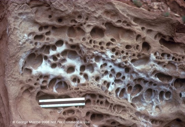
Área intermareal La intemperie intermareal se encuentra en planos horizontales, en rocas dentro de la zona de marea (rocas que están cubiertas por marea alta, pero que quedan expuestas durante la marea baja). El crecimiento de este tipo de desgaste en forma de nido de abeja está limitado por el grado de evaporación del sol. Una vez que las depresiones se han hecho lo suficientemente grandes como para que el sol no pueda evaporar toda el agua que queda en el hueco cuando la ola se retira, los agujeros han alcanzado su tamaño máximo, porque la sal ya no puede secarse ni separar los granos. La zona intermareal es el área que queda cubierta por agua de mar durante la marea alta, que queda al descubierto durante la marea baja, y donde las olas se estrellan en el intervalo de tiempo entre la marea alta y la baja. 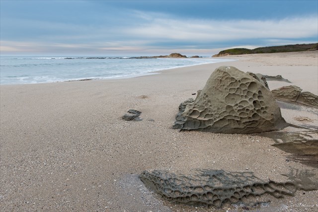
Área suprantaria Todavía se está estudiando la causa por la que se produce ese patrón característico de panal de abeja en las áreas suprantarias (es decir, las áreas que están por encima de la marca de marea alta y que no están sumergidas en el mar) en el plano vertical. Algunos geólogos creen que las paredes laterales de los alvéolos pueden estar protegidas de la erosión salada por las algas microscópicas; mientras que otros creen que los responsables pueden ser ese endurecimiento del marco, la exposición al viento y al sol, los ciclos de humectación y secado o las variaciones mineralógicas en la piedra. De acuerdo con Tom Paradise, uno de los investigadores más destacados en el tema de la meteorización en panal, lo más probable es que lo que produzca estas delicadas estructuras sea una combinación de todos estos factores. 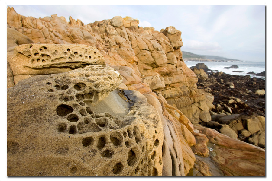
Humectación y secado Desde el desierto occidental del extremo suroeste de Egipto, hay grandes ejemplos de tafoni en la piedra arenisca del bajo Paleozoico. El agua, incluso en cantidades mínimas, se acumula en la superficie o se abre paso entre los granos de roca y se seca. Si el agua transporta sales (o bien las sales se encuentran en la roca), los minerales disueltos en el agua, que pueden incluir cloruro de sodio, pero también una gran cantidad de otros cloruros, sulfatos y carbonatos, se cristalizarán a medida que el agua se seque. Las sales cristalizantes aumentan su volumen, como se mencionó anteriormente, lo que produce presiones significativas entre los granos, lo que obliga a la roca sólida a desmoronarse. La solidez química y física de cualquier roca no es uniforme y algunas partes serán más vulnerables que otras; el proceso continúa a través de ciclos de humedecimiento y secado, cincelado, excavación y suavizado. Los resultados pueden ser pozos de "panal" relativamente simples o esculturas increíblemente adornadas, que llegan a recordar a las catedrales góticas. 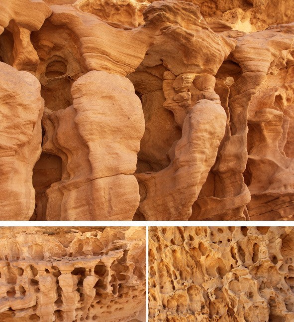
Ciclos de congelación-descongelación El desgaste por congelación-descongelación es un proceso de erosión que ocurre en áreas frías donde se llega formar hielo. Una grieta en la roca se puede llenar de agua, que luego se congela cuando desciende la temperatura. A medida que el hielo se expande, ejerce presión sobre la grieta, haciéndola más grande. Cuando la temperatura sube nuevamente, el hielo se derrite y el agua llena las partes de la grieta que acaban de abrirse. El agua se congela de nuevo cuando desciende la temperatura, y la expansión del hielo provoca una mayor expansión de la grieta. Este proceso continúa hasta que la roca se rompe. 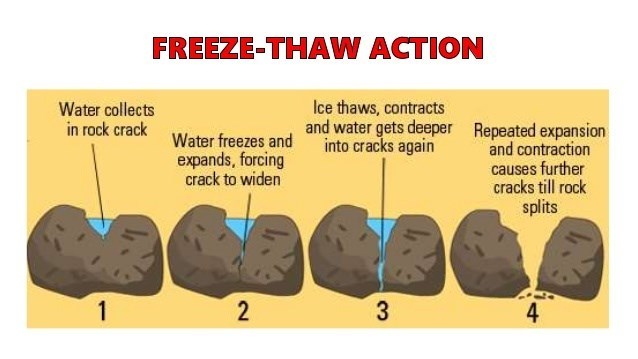
Viento La erosión del viento ocurre en zonas donde hay viento. Los paisajes que están más dibujados por la erosión eólica de forma más drástica son los desiertos y las costas. En estas áreas, hay menos raíces de plantas que anclen el suelo y la arena en su lugar, para reducir la cantidad de erosión eólica. La saltación es el movimiento de arena u otros sedimentos por saltos cortos y rebotes causados por el viento o el agua. Como en estas playas el viento sopla de sur a norte, pasa alrededor de la roca por en medio del pasillo de la playa.
Al hacerlo, crea un efecto de remolino en el lado norte de la roca. Si te paras cerca de la roca, junto al tafoni, en un día de viento, sentirás cómo la arena gira alrededor de tus piernas. Parece ser que este remolino de arena y partículas de polvo juega cierto rol en cómo se crea el tafoni de esta roca. Existen otras teorías que intentan explicar la presencia de tafoni en áreas costeras. 
Algunos investigadores creen que, además de la meteorización salina, los moluscos y otras formas de vida marina también pueden intervenir en el inicio del tafoni. Lo hacen creando pequeños agujeros en las costas rocosas, donde se adhieren y extraen minerales. El orificio crece con el tiempo, hasta que el molusco u otro organismo desaparece. El agujero queda expuesto a los elementos, como el viento, la lluvia y el agua de las mareas. Estos trabajan de forma conjunta para crear las formaciones tafoni.
Para poder registrar este earthcache debes responder las siguientes preguntas:
1. En la roca situada en las coordenadas del geocaché, describe el tafoni (tamaño, forma, cantidad).
2. ¿Hay tafoni en todos los lados de la roca? ¿Por qué crees que ocurre así?
3. Al mirar hacia las paredes del acantilado al este y al oeste, ¿ves tafoni en esas caras del acantilado? Si es así, describe lo que ves.
4. En el punto de observación 1 (N 22 ° 52.537 'W 109 ° 53.770') verás unas rocas grandes que se encuentran en la zona intermareal. ¿Ves algún tafoni en estas rocas? (Las grandes rocas en la playa, no en el acantilado)
5. Después de visitar este lugar y de leer la información de la página del caché, ¿cómo crees que se formó el Tafoni de Lands End?
6. Publica una foto tuya o un objeto personal en la roca con una de las playas en el fondo que muestre que visitaste el sitio. REQUERIDO
NOTA: Si publicas CUALQUIERA de las respuestas a estas preguntas en tu registro (esté cifrado o no), se eliminará. Si no envías un correo electrónico dentro de los 7 días posteriores de tu registro como "encontrado", se eliminará tu registro. Os animo a subir imágenes (¡hace esto más divertido!), siempre que éstas no ayuden a que un geocacher pueda resolver las preguntas desde casa. Si estás haciendo geocaching en grupo, no tenéis más que enviar un único correo electrónico. Eso sí: la persona que envíe las respuestas DEBE hacer referencia a cada uno de los geocachers de ese grupo, por su nick (no es necesario enviar 12 correos electrónicos, cuando es suficiente un correo electrónico con 12 nombres de usuario).
Special Thanks to LosRichart from Cartagena, Spain for the Spanish translation.

You must walk on the beach to claim this cache! You can not complete the logging requirements from a boat in the water.
This earthcache is about the tafoni located at Lands End, just South East of Cabo San Lucas. You cannot hike to lands end, it can only be accessed by boat. A very inexpensive trip by water taxi can be purchased at the Marina. Once there, you will be looking for this rock in the middle of the beach passageway to start this cache.
Tafone (plural Tafoni) are ellipsoidal, pan- to bowl-shaped, natural rock cavities. These cavernous weathering features include tiny pits, softball-sized cavities, truck-sized caves, and nested and cellular honeycomb forms. Tafoni typically develop on inclined or vertical surfaces and occur in groups. These exquisite and fascinating cavernous weathering landforms are present on the surfaces of many different kinds of rocks located in a multitude of geographic regions around the world. Since the late 1800s, more than 100 research articles have been published in numerous languages on this geomorphic topic. Tafoni development and evolution is puzzling and continues to arouse curiosity.
How Are Tafoni Formed? Several theories have been presented to explain tafoni formation, including: freezing-thawing, wetting-drying, salt weathering, intratidal, as well as supratidal weathering, but exactly how or why tafoni occurs can vary greatly depending on who you ask, and/or the rocks and location it is found. One thing that is widely agreed upon is that generally some form of salt is involved.
Is salt essential? The typical occurrence of tafoni in high saline environments (e.g., arid deserts, intertidal areas) is strong evidence that salt likely plays a crucial role in tafoni formation. However, the explanation of salt weathering as a physico-chemical cavernous weathering agent is incomplete because it does not account for why tafoni develop in some but not all coastal rocks. Accordingly, in addition to salt, researchers emphasize additional controls and weathering agents that work to create tafoni.
Salt weathering also called honeycomb weathering, fretting, cavernous weathering, alveoli/alveolar weathering, stone lattice, stone lace or miniature tafoni weathering, common on coastal and semi-arid granites, sandstones and limestones is the most common explanation. It occurs when salt collects on the surface of permeable rocks, usually by ocean waves, mist, or wind. As the saltwater evaporates, it leaves the salt behind. The salt works its way into the rock pores, where it crystallizes expanding by 1% to 5% and pushes the pores open further. These enlarged rock pores become susceptible to additional weathering. After a significant amount of time, the weathering becomes noticeable in the form of tafoni.
Intertidal Area Intertidal honeycomb weathering is found on horizontal planes in rock within the tidal zone (rocks that are covered by high tide, but exposed during low tide). This type of honeycomb weathering is limited in its growth by the rate of evaporation from the sun. Once the depressions have grown large enough that the sun can not evaporate all of the water left in the gap by the retreating wave, the holes are as large as they will get, because the salt can not dry out and wedge grains apart any longer. The intertidal zone is the area that is covered by sea water during high tides, uncovered during low tides, and where waves crash in the times in between high and low tides.
Supratidal Area The cause of the characteristic honeycomb pattern in supratidal areas (areas that are above the high tide mark and are not submerged in sea water) on the vertical plane is still under debate. Some geologists believe that the side walls of the alveoli may be protected from salt weathering by microscopic algae, while others believe that case-hardening, wind and sun exposure, wetting and drying cycles or mineralogical variations within the stone may be responsible. According to Tom Paradise, one of the prominent researchers on the topic of honeycomb weathering, most likely a combination of these factors produces these delicate structures.
Wetting-drying From the Western Desert of extreme southwest Egypt there are great examples of tafoni in Lower Paleozoic sandstones. Water, even in minimal amounts, pools on the surface or finds its way in between the rock grains and dries. If the water is carrying salts (or salts are found in the rocks themselves) - minerals dissolved in the water than can include sodium chloride but also a host of other chlorides, sulphates, and carbonates - then they will crystallize out as the water dries. Crystallizing salts increase their volume as mentioned above, which produces significant pressures between the grains, forcing the solid rock to crumble. The chemical and physical solidity of any rock is not uniform and some parts will be more vulnerable than others; the process continues through cycles of wetting and drying, chiseling, excavating, and smoothing. The results can be relatively simple "honeycomb" pits or incredibly ornate sculptures, reminiscent of Gothic cathedrals.
freezing-thawing cycles Freeze-thaw weathering is a process of erosion that happens in cold areas where ice forms. A crack in a rock can fill with water which then freezes as the temperature drops. As the ice expands, it pushes the crack apart, making it larger. When the temperature rises again, the ice melts, and the water fills the newer parts of the crack. The water freezes again as the temperature falls, and the expansion of the ice causes further expansion to the crack. This process continues until the rock breaks.
Wind Wind erosion happens everywhere there is wind, the landscapes that are most dramatically shaped by wind erosion are deserts and coastlines. In these areas, fewer plant roots anchor soil and sand in place to reduce the amount of wind erosion. Saltation is the movement of sand or other sediments by short jumps and bounces caused by wind or water.
As the wind blows from south to north on these beaches it passes around the rock in the middle of the beach passageway. As it does this it creates a swirling effect on the north side of the rock. If you stand close to the rock by the tafoni on a windy day you will feel the sand swirl about your legs. The swirling of sand and dust particles I believe plays a partial roll in how the tafoni is created in this rock.
Other theories attempt to explain the presence of tafoni in coastal areas. Some researchers believe that, in addition to salt weathering, mollusks and other marine life may also initiate tafoni. They do this by creating small holes in the rocky coastlines, where they attach themselves and extract minerals. The hole grows larger over time until eventually the mollusk, or other organism, drops off. The hole is then left to the elements, like wind, rain, and tidal water. These work together to create the tafoni formations.
In order to claim this earthcache you must answer the following questions:
1. On the rock at the geocache location, describe the tafoni (size, shape, amount).
2. Do you find tafoni on all sides of the rock? Why do you think that is?
3. As you look up the cliff walls to the East and West do you see any tafoni on the cliff faces? If so, describe what you see.
4. At observation spot 1 (N 22° 52.537' W 109° 53.770') you will see large rocks that are located in the intertidal zone. Do you notice any tafoni on these rocks? (The large rocks on the beach, not up on the cliff)
5. After your visit to this location, and reading the information on the cache page, how do you think the Tafoni here at Lands End formed?
6. Post a picture of yourself or a personal item at the rock with one of the beaches in the background that shows you visited the site. REQUIRED
NOTE: If you post ANY answers to the questions above in your log (encrypted or not) it will be deleted. If you fail to send an e-mail within 7 days of your 'found' log, your log will be deleted. I encourage pictures (it makes it fun!) but nothing that will help an arm chair cacher answer any of the questions. If you are caching as a group, only one e-mail needs to be sent. The person sending the answers MUST reference each individual in the group by caching name, no need to send 12 e-mails when one e-mail with 12 usernames will be sufficient.
Information sources:
1. www.tafoni.com
2. www.usgs.com
3. https://tasmaniangeographic.com/what-is-tafoni/
4. Photos used with permission from George Mustoe, Michael Welland,