Observing the Machtesh EarthCache
-
Difficulty:
-

-
Terrain:
-

Size:  (other)
Please note Use of geocaching.com services is subject to the terms and conditions
in our disclaimer.
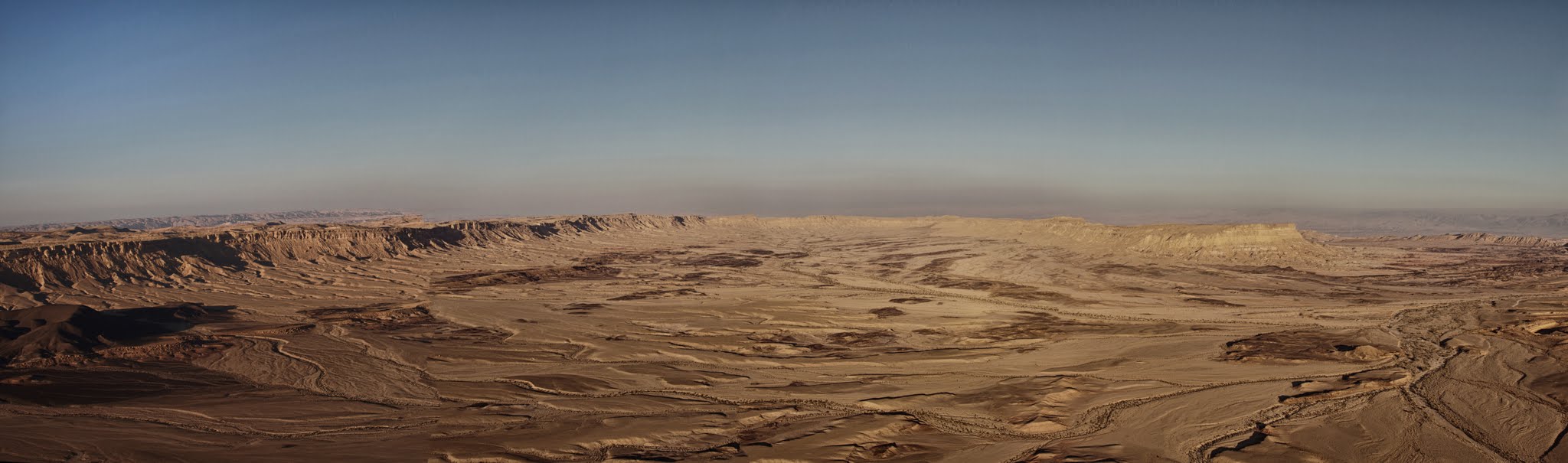
This earthcache will take you to a breathtaking view point about the Ramon crater
מטמון זה יביא אתכם לתצפית עוצרת נשימה מעל מכתש רמון ל
The English text will be followed by an Hebrew one.
What is a crater and what is a geological Crater?
The simplest explanation is : a crater is a "dent" the is surrounded by tall walls or clear boarders. There are many craters around the world that were formed due to colliding meteor or ,meteorites, Those are rare and Meteor crater in Arizona (us) is probably one of there more famous ones. Other more common types are the ones formed by active or temporary dorme volcanoes like Etna in Sicilia and the English term for those are Crater
The Machtesh is not a crater since it is a geological crater. In fact all the crater in Israel are geological crater, which is a unique phenomena that can be found mostly in Israel and in the Sinai dessert. Their formation is so different then regular crater that the Hebrew word for a crater , which is a Machtesh became the official word to describe this type of crater.
How does a geological crater : Machtesh forms?
About 100 millions years ago this entire area was covered by an ancient ocean, called the Tethys Ocean. These created a situation were soft rocks, sand and plants on the bottom of the ocean were covered by hard rock. Calcium rich skeletons from creatures living in the sea enriched the rocks with calcium and helped form harder rocks on the bottom of the ocean creating a 3 layers structure of soft rocks, hard rocks and sea that became shallower with time. Now everything was ready to create the Macthesh:
A. The movement of the earth's crest caused pressures that help "squized" the layers and created/formed mountains (or tall landscape) that are covered by hard chalk rocks on the outside and soft sand stones in the inside. This process took about 50 million years.
B. The top of those mountains, the hard rock was exposed to weathering process exposing the soft rocks underneath.
C. Rains, rivers and even floods are penetrating the hard rock, dissolving or removing the soft rock. At one point there is nothing to support the heavy layers of the hard rock and it simply collapses increasing the area of the newly formed crater

I hope now you appreciate the Machtesh even more, in order to log it:
-
The ancient Tethys Ocean contained so many different creatures and so many different minerals were created inside of it. While the ocean doesn't exist anymore by looking at the crater can you spot the different minerals? Explain
-
Does the Machtesh can be called a crater based on my simplest explanation ?
-
Can you see any tall mountains inside the Machtesh ? why is that?
-
According to your GPS what height are you at ?

מה זה מכתש ומה זה מכתש גאולוגי ?
ההגדרה הבסיסית ביותר אומרת: מכתש זה קימוט/שקע המוגף קירות או גבולות ברורים. ישנם מספר סוגי מכתשים בעולם. חלק נוצרים ע"י פגיעת מטאורים או מטאוריטים. מכתשים אלו הינם נדירים והדוגמא המפורסמת ביותר למכתש מסוג זה היה "מכתש המטאור" באריזונה (ארה"ב). סוג יותר נפוץ של מכתשים אלו הם מכתשים שנוצרו כתוצאה מהתפרצות הר געש פעיל או רדום זמנית כמו באטנה שבסיציליה. אלו הם מכתשים.
המכתש הגדול שגם באנגלית מכונה Mactesh הוא מכתש גאולוגי. למעשה כל המכתשים בישראל הינם מכתשים גאולוגים וזו תופעה מיוחדת שישנה רק בישראל ובמספר מקומות במדבר סיני. תהליך ההיווצרות שלהם שונה לחלוטין ממכתשים רגילים ולכן המילה העברית מכתש הפכה לשם לתופעה.
אז איך נוצר מכתש גאולוגי ?
לפני כ100 מיליון שנה כל האזור היה מכוסה בים קדום, ים טטיס. בזכות אותו ים קדום, נוצר מצב שצמחים, חול וסלעים רכים כוסו בשכבה קשה של מסלע. השלדים עשירי הסידן של היצורים שחיו בים שקעו לקרקעית והעשירו את הסלעים בסידן או יצרו מסלע קשה בעצמם ככה שנוצרו 3 שכבות של חול/מסלע רך, מעליו סלעים קשים ומעליהם מים. עם הזמן גם הים החל להיות רדוד יותר וכעט נוצרו התנאים למכתש גאולוגי
א. תנועת קרום כדור הארץ יצרה לחץ שלעשה "קימט" את השכבות ויצר הרים בקרקע המכוסים סלע גיר קשה מבחוץ וסלע רך/חול מבפנים. תהליך זה לקח כ50 מיליון שנה.
ב. פסגות אותם הרים/ חלקם העליון נחשף לתהליכי בלייה טבעיים שחשפו או נתנו גישה להשכבות התחתונות
ג. גשים, נחלים ושיטפונות חדרו לשכבות התחתונות, המיסו את הסלעים הרכים או סחפו אותם ואת החול עימם ככה שנותר מצב שלא היה שום תמיכה לשכבות הקשות והן התמוטטו והגדילו את שיטחו של המכתש החדש שנותר.
מקווה שכעת את מעריכים את המכתש יותר כדי "למצוא" את המטמון ענו על השאלות
א. ים טטיס הקדום הכיל המון יצורים ומינראלים בתוכו. הים כבר לךא קיים אבל האם אתם רואים עדות למינראלים השונים מהתצפית ? הסבירו
ב. לפי ההגרה הבסיסית האם המכתש הגדול עומד בהגדרה של מכתש?
ג. האם אתם מסוגלים לראות הרים בתוך המכתש? למה אתם חושבים שזה המצב?
ד. לפי המכשיר שלכם/סמארטפון מה גובה התצפית ?
Additional Hints
(Decrypt)
Rawbl gur ivrj