Skip to content

Istmo das tartarugas 🐢 EarthCache

Hidden : 1/27/2018
Difficulty:
1.5 out of 5
Terrain:
1.5 out of 5

Size: Size:   other (other)

Join now to view geocache location details. It's free!

Watch

How Geocaching Works

Please note Use of geocaching.com services is subject to the terms and conditions in our disclaimer.

Geocache Description:


https://s3.amazonaws.com/gs-geo-images/babb961b-fcc1-4c8e-948e-b4a8923ed865.jpg
Earthcache é simples:  Visitar o local, Ler a página do cache, Responder as perguntas para o owner (não no log) e então Registrar... Qualquer dúvida entre em contato
Earthcache is simple:  Visit the site, Read the cache page, Answer the questions for the owner (not in the log) and then Register... Any questions please contact us

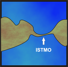
A ponte que une o Boi à Tartaruga (zoônimos dos acidentes geográficos locais)

A Ilha das Tartarugas, localizada no balneário de Caiobá, é um sítio arqueológico tombado pelo IPHAN desde 1989. Pois nessa ilha se encontram vestígios do homem Sambaqui,considerado um dos primeiros habitantes da região.
Pode ser visitada por um fácil acesso, seguindo o istmo pelas pedras e chegando até uma trilha que leva a uma torre e o outro lado, onde a vista é linda com um visual do outro lado do mar.
Esta travessia pode ocasionar uma infeliz surpresa, pois em horários alternados a maré sobe e cobre a passagem natural, podendo deixar um desavisado preso na ilha.

 
Istmo é uma estreita faixa de terra, um acidente geográfico que une duas áreas de território. permitindo que as duas extensões diferenciadas se mantenham em contato. Neste sentido, um istmo pode unir duas ilhas, duas massas continentais e uma península com um continente. Pode possuir comprimento variado, neste nosso exemplo ele une a ilha ao continente.
Apenas para uma imagem mental, o inverso do istmo (que localiza-se entre duas massas de água e conecta duas grandes massas terrestres) seria um estreito (que fica entre duas massas terrestres e ligam duas grandes massas de água.
A palavra é de origem grega, isthmos significa pescoço. Nome dado pelos gregos antigos à pequena tira que separa do continente europeu a região sul daquele país, chamada Peloponeso, que mais tarde viria a ser conhecida como istmo de Corinto.
Posteriormente a palavra passou a designar todas as ligações de península com terra firme e, mesmo a ligação entre dois continentes, como nos casos dos istmos do Suez e do Panamá. Em alguns desses locais foram construídos canais de navegação que possibilitam aos navios passarem de um para outro mar ou oceano, sem necessidade de percorrerem grandes distâncias.
 
A formação dos istmos tem sido atribuída a diversas causas. Uma delas seria pela erosão marinha, tendendo então tais istmos a desaparecerem, como desapareceram os de Bering, que ligava a Ásia ao continente americano, o de Gibraltar, entre a África e a Europa, e de Calais, no estreito de Dover, canal da Mancha, que separa a França da Inglaterra. Frequentemente, porém, eles seriam devidos a fraturas incompletas em regiões vulcânicas, considerando-se dessa forma os istmos do Panamá e de Corinto.
 

O detalhe importante para compreender a formação e comportamento ao longo do tempo (evolução do relevo), é que foi ocorrido de acordo com dois tipos de processos: endógenos e exógenos. 
Os processos endógenos estão ligados à dinâmica interna da Terra ou dinâmica da litosfera (tectonismo, magmatismo, metamorfismo, orogênese e epirogênese). Estes processos modificam a posição altimétrica e a orientação das vertentes preexistentes. Dessa forma, são os processos endógenos então, os responsáveis pela construção do relevo.
Os exógenos são responsáveis por moldá-lo. Estes tipos de processos estão ligados à dinâmica externa da Terra (Atmosfera e superfície terrestre). Exemplos deste são o intemperismo, a ação pluvial, a ação eólica, ação do gelo, ação biológica e antrópica, entre outros.
Os processos endógenos constroem o relevo, os exógenos são responsáveis por moldá-lo.

A “Geomorfologia de encostas” é o ramo que estuda a atividade em sopés (base) de morros e montanhas, como os movimentos de massa (deslizamentos) e manutenção de encostas.
Devido posição e dos tipos de sedimentos sugere-se que os blocos neste istmo são originarios da vertente convexa do Morro do Boi, moldado pelo movimento das águas marinhas e também por interferência antrópica (relativo à ação do homem)
O morro do Boi, assim como os demais morros da baixada litorânea, são constituídos por gnaisses e migmatitos de idades pré cambrianas, inferiores à 550 milhões de anos. Estas rochas estão cortadas por diques de diabásio com idades de 130 milhões de anos, originados durante
a abertura do Oceano Atlântico Sul.

Se você visitou este local e leu corretamente a descrição PODE FAZER O LOG no Earthcache, envie as respostas via mensagem, se elas porventura NÃO estiverem corretas eu entrarei em contato
Questões:
1- O que é um istmo? Descreva o que vê neste local
2- Quais processos formaram esse relevo, fazendo surgir o Morro do Boi e a Ilha da Tartaruga e quais os moldaram, formando o istmo que os liga?
3- O movimento das marés influi diretamente nesta formação e moldagem. Com base nos pontos cardeais, qual o sentido da força exercida pelo movimento das águas, através das ondas, no istmo?
4-Gostou de conhecer o local? Uma foto sua no local seria ótimo (opcional)
 

 https://image.freepik.com/fotos-gratis/ingles-linguagem-bandeira-do-grunge_61-1173.jpg
Translated by Google
If anyone has a suggestion for improving this, please contact
 
The bridge linking the Ox to the Turtle

Tartarugas Island, located in the resort of Caiobá, is an archaeological site that has been classified by IPHAN since 1989. For this island there are vestiges of the Sambaqui man, considered one of the first inhabitants of the region.
It can be visited by easy access, following the isthmus by the stones and arriving until a trail that leads to a tower and the other side, where the view is beautiful with a visual of the other side of the sea.
This crossing can cause an unfortunate surprise, because at alternate times the tide rises and covers the natural passage, leaving an unsuspecting prisoner on the island.

Istmo is a narrow strip of land, a geographical accident that unites two areas of territory. allowing the two differentiated extensions to stay in touch. In this sense, an isthmus can unite two islands, two continental masses and a peninsula with one continent. It can have varied length, in our example it joins the island to the mainland.
Just for a mental image, the inverse of the isthmus (which lies between two bodies of water and connects two large land masses) would be a narrow one (which sits between two land masses and connects two large bodies of water.
The word is of Greek origin, isthmos means neck. The name given by the ancient Greeks to the small strip separating the southern region of that country called the Peloponnese, which later became known as the Corinthian Isthmus.
Subsequently the word went to designate all the connections of peninsula with terra firma and, even the connection between two continents, as in the cases of isthmus of Suez and Panama. In some of these places, navigation channels have been constructed that allow ships to pass from sea to ocean or ocean without having to travel long distances.

The formation of the isthmus has been attributed to several causes. One of them would be the erosion of the sea, and then these islands disappeared, as did those of Bering, which linked Asia to the American continent, Gibraltar between Africa and Europe, and Calais, in the Strait of Dover, Manche, which separates France from England. Frequently, however, they would be due to incomplete fractures in volcanic regions, thus considering the isthmus of Panama and Corinth.
 

The important detail to understand the formation and behavior over time (evolution of the relief), is that it occurred according to two types of processes: endogenous and exogenous.
The endogenous processes are linked to the internal dynamics of the Earth or lithosphere dynamics (tectonism, magmatism, metamorphism, orogenesis and epirogenesis). These processes modify the altimetric position and orientation of the preexisting slopes. In this way, it is the endogenous processes that are responsible for the relief construction.
Exogenous people are responsible for molding it. These types of processes are linked to the external dynamics of the Earth (Atmosphere and Earth's surface). Examples of this are weathering, pluvial action, wind action, ice action, biological and anthropic action, among others.
The endogenous processes build the relief, the exogenous are responsible for molding it.

"Geomorphology of slopes" is the branch that studies the activity in sops (base) of hills and mountains, as the mass movements (slides) and maintenance of slopes.
Due to the position and types of sediments it is suggested that the blocks in this isthmus originate from the convex slope of Morro do Boi, shaped by the movement of the marine waters and also by anthropic interference (relative to the action of man)
The Morro do Boi, as well as the other hills of the coastal lowland, are made up of gneisses and migmatites of pre-Cambrian ages, less than 550 million years old. These rocks are cut by diabase dikes of 130 million years old
the opening of the South Atlantic Ocean.

If you have visited this site and read the description correctly you can log on to Earthcache, send the responses to owner, if they are not correct I will contact you
Questions:
1- What is an isthmus? Describe what you see on this site
2 - Which processes formed this relief, giving rise to Morro do Boi and Turtle Island and which shaped them, forming the isthmus that binds them?
3- The movement of the tides directly influences this formation and molding. On the basis of the cardinal points, what is the sense of the force exerted by the movement of the waters, through the waves, in the isthmus?

4- Did you like the place? A photo of you on the spot would be great (optional)

 
https://s3.amazonaws.com/gs-geo-images/bde10fd2-4c7a-4620-a26c-4a2edc915895.jpg


Additional Hints (No hints available.)