The purpose of this earthcache is to provide people like me, who know very little about the environment, with an opportunity to increase their knowledge-base and to develop a deeper appreciation and respect for the world we live in. The lessons and related questions are brief, quick to answer and easy to remember for a lifetime! As with all Earthcaches, please be respectful of the land.
This Earthcache is one of four related Earthcaches that will bring you on a journey of exploration to several locations on Upper Cape Cod. Each location will introduce you to a geologically significant formation due to glacial impact.
CONGRATS TO SEIERS FOR BEING FTF (First to Finish!)
Definition of terms:
Estuaries: bodies of water in coastal areas that are formed when fresh water from rivers flows into and mixes with salt water from the ocean. In estuaries, the fresh river water is blocked from streaming into the open ocean by either surrounding mainland, peninsulas, barrier islands, or fringing salt marshes. The estuary gathers and holds an abundance of life-giving nutrients from the land and from the ocean, forming an ecosystem that contains more life per square inch than the richest Midwest farmland.
Estuaries are a critical source for much of our ocean life. They provide essential habitat for over 75 percent of our nation's commercial fish catch. Commercial and recreational fishing, boating and tourism also provide more than 28 million jobs. Estuaries, in short, are national treasures -- vital ecological and community resources whose health affects our health and the vibrancy of our communities and economy.
Along with variations in size, estuaries also vary based on their geology (kind) and water circulation (type).
Estuaries are typically classified by their existing geology or their geologic origins (in other words, how they were formed). The five major kinds of estuaries classified by their geology are coastal plain, bar-built, delta, tectonic and fjord. In geologic time, which is often measured on scales of hundreds of thousands to millions of years, estuaries are often fleeting features of the landscape. In fact, most estuaries are less than 10,000 years old.

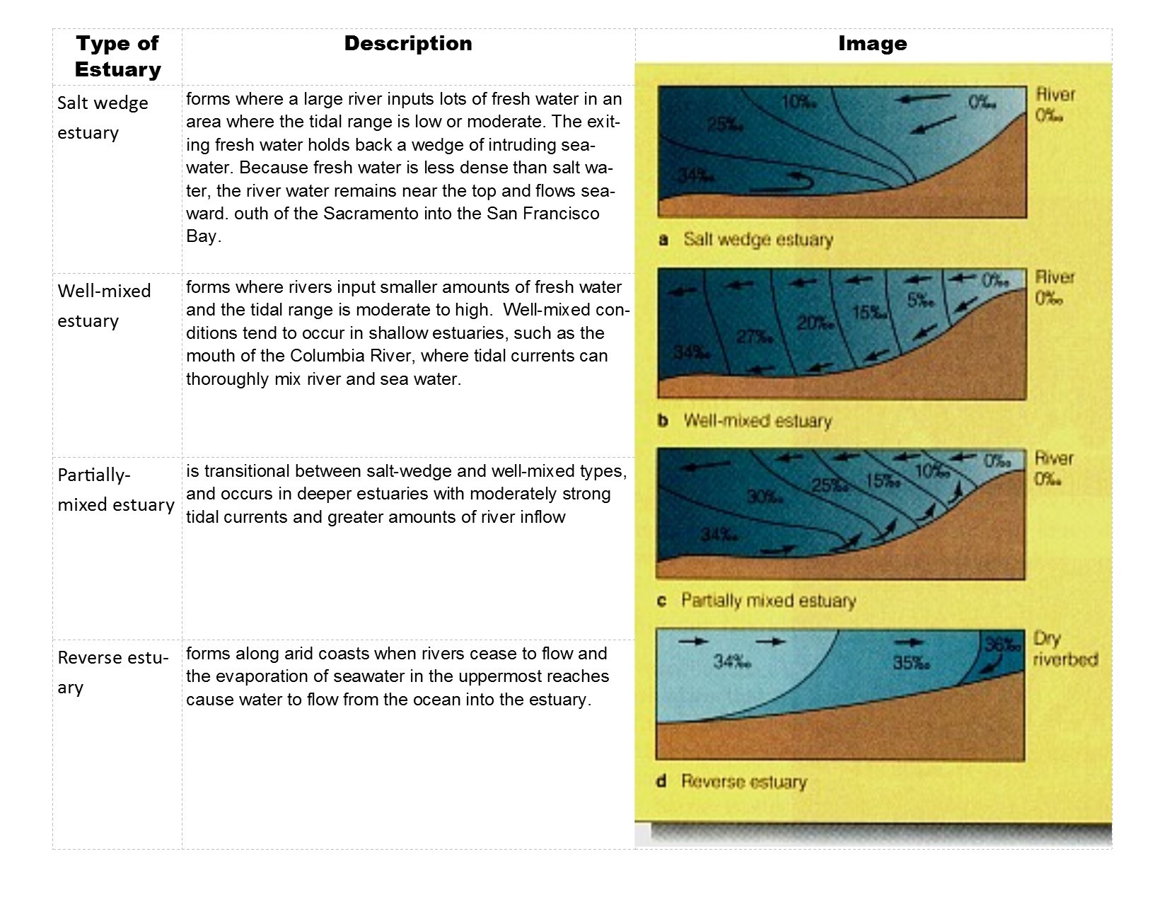
Four Types of Estuaries: Based on their natural characteristics and level of salinity, estuaries can be divided into four main types: salt-wedge, well-mixed, partially-mixed and reverse (or lagoon).
Waquoit Bay N 41 34.824 W 70 31.502
This beautiful and awe-inspiring bay is a part of Nantucket Sound and is located on the southern shore of Cape Cod at the edge of the outwash plain on which Falmouth MA is established. It forms the border of the towns of Falmouth and Mashpee. The name ‘Waquoit’ comes from the Wompanoag word Weeqayut (Waquoit) meaning ‘Place of Light’ (hence the name of this Earthcache).
The main bay is connected to numerous salt ponds, several fresh water tributaries and has two (sometimes three) inlets to Nantucket Sound. The bay and surrounding waters are designated by the state and federal government as the Waquoit Bay National Estuarine Research Reserve (WBNERR) whose mission is to protect the resources of the bay and to facilitate research that improves the understanding of coastal systems, including its geological origins. Freshwater enters the Bay from four principal sources: the Quashnet/Moonakis River, Red Brook, Childs River, and groundwater overflow.
According to Robert Oldale, USGS, many of the coastal salt ponds seen on Cape Cod, including Waquoit Bay, originated either as kettle ponds, as the lower extreme of outwash plain valleys, or as kettle ponds that intercepted an existing valley. Beth Schwarzman, author of The Nature of Cape Cod (UPNE. 2002.) suggests that its origin is probably not related to kettle holes, but most likely “where the four springsapping valleys that enter the bay (come together) at their mouths”. The southern extremes of these valleys were flooded by sea-level rise and are now coastal salt ponds. Then, long finger-like projections or spits began to form as sediment-laden longshore currents encountered the particular features of the area.
The shape and appearance of the barrier spits at Waquoit Bay as well as other coasts are continuously refined by longshore currents that rob some areas of sands while depositing sands in other areas. Physical processes are not the only factors responsible for the shape of a barrier beach. Vegetation on the backshore of a sand bar stabilizes the sands, promoting further deposition and an increase in the height of the beach, eventually resulting in the development of dunes. Dunes raise the level of the beach up above the level of the highest tide, thereby reducing the risk of overwash.
The Waquoit Bay drainage area is located within the Mashpee outwash plain. This plain, which serves as its watershed, is shaped like a large fan and radiates from its highest point near the conjunction of the Buzzard's Bay and Sandwich moraines south toward Vineyard Sound. The outwash plain is a mixture of sand and gravel layers, with some clay and silt lenses; finer grained sediments predominate in deeper layers and to the south. The Mashpee outwash plain is sometimes called the "pitted" outwash plain due to the presence of numerous kettles. Kettles formed when blocks of glacier ice were buried under flowing outwash sediments; over time the blocks melted, and the overlying ground collapsed, giving it a pitted appearance. Numerous kettle holes deep enough to intercept the groundwater table eventually filled with water to form ponds and lakes.
1. Name no fewer than two characteristics that distinguish an estuary from other bodies of water.
2. From your current location at the posted coordinates, what ‘kind’ of estuary is Waquoit Bay, and what is the visual evidence to support your answer?
3. Which ‘type’ of estuary is Waquoit Bay (provide objective evidence based on your vantage point at the posted coordinates to support your response)?
4. OPTIONAL: Post a picture of the Bay from the posted coordinates. It is entirely up to you whether you choose to include yourself in the photo.
Resources:
1. Massachusetts Estuaries Project: Linked Watershed-Embayment Model to DetermineCritical Nitrogen Loading Thresholds for Sesachacha Pond, Town of Nantucket, Massachusetts. 2009.
2. Schwarzman, Beth. The Nature of Cape Cod. University Press New England. 2002.