RN40 (SAL) – Quebrada de Las Flechas (EarthCache) EarthCache
RN40 (SAL) – Quebrada de Las Flechas (EarthCache)
-
Difficulty:
-

-
Terrain:
-

Size:  (other)
Please note Use of geocaching.com services is subject to the terms and conditions
in our disclaimer.
| La Quebrada de Las Flechas |
 Quebrada de las Flechas Quebrada de las Flechas
|
|
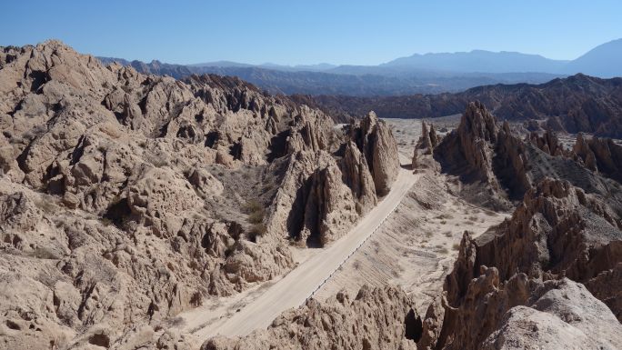
Varios millones de años atrás, grandes bloques de rocas antiguas comenzaron a elevarse al borde de la Puna. Las profundas fallas de la corteza levantaron rocas graníticas y metamórficas que formaron un contrafuerte montañoso. Son las rocas duras y cristalinas del Período precámbrico que da origen a las cumbres en el oeste del valle actual. Hacia el este se extendía una llanura con pocos relieves.
Los vientos húmedos del Atlántico llegaban allí y descargaban su humedad. Las viejas rocas graníticas y metamórficas fueron erosionadas y arrastradas por los ríos y se depositaron en la llanura donde se encuentran ahora en grandes abanicos aluviales. Un estudio detallado de la composición de estos materiales, nos permite determinar que corresponden a arenas gruesas y gravas donde el cuarzo predomina, variando del orden del 55 al 68%. El resto está formado por feldespato, tanto potásico como plagioclasa, así como mica y otros elementos líticos
Con el tiempo, estos materiales paulatinamente se convirtieron en rocas, que técnicamente se clasifican como Arenitas y Vaques, tanto líticas como feldespáticas. Todas ellas conformaron una formación estratigráfica que hoy se conoce como Formación Angastaco por ser dicha localidad, el lugar donde presenta su mejor expresión.
En la parte superior de esta formación se depositaron otros materiales más finos como sedimentos arcillosos que pueden contener restos fósiles (hojas y troncos), lo que nos da la pauta que hace millones de años esta región poseía un clima de tipo tropical.
En el Mioceno tardío (hace 6 a 10 millones de años) los Andes continuaron evolucionando hacia el este y formaron nuevas cadenas montañosas (por ejemplo, la Sierra de los Colorados). Estos comenzaron a aislar la región al detener las lluvias y convertir el territorio en un desierto.
La presión ejercida por la masa andina sobre el contrafrente de la puna, elevó casi verticalmente aquellos estratos angastaqueños que habían quedado entre ambas masas montañosas y los expuso a la erosión típica de las lluvias, cortas pero fuertes, del verano. Los materiales blandos y frágiles comenzaron a ceder por la fuerza de esas lluvias y la acción constante del viento, formando el peculiar paisaje en forma de flecha que ahora se conoce como "Quebrada de Las Flechas”.
Imagen tomada de [1] |
| Para registrar este caché como encontrado, debe enviarme las respuestas a las siguientes preguntas a través de mi perfil: |
|
1. Mida o intente estimar el ángulo de inclinación de las rocas circundantes (suponiendo que 0° es horizontal)
2. ¿Cuándo se originó la Quebrada de las Flechas? (*)
3. ¿Qué dio origen a la típica forma de punta de flecha? (*)
4. Opcional: vaya al punto de vista y haga una fotografía de usted y / o del paisaje.
(*) En el lugar hay paneles informativos que pueden ayudarle con las respuestas.
|
| Recomendaciones |
Elementos mínimos:
- Ropa cómoda / Ropa de abrigo (llega a -5 ºC de mínima en invierno y a mas de 35 ºC en verano)
- Calzado adecuado para trekking, con suela antideslizante
- Protector solar
- Sombrero, Gorra, Agua.
El acceso a este lugar y al panel de información es libre y gratuito y puede llegar a él directamente desde la RN40.
|
 Quebrada de las Flechas Quebrada de las Flechas
|
|
Several million years ago, large blocks of ancient rocks began to rise to the edge of the Puna. The deep faults of the crust raised granite and metamorphic rocks that formed a mountainous buttress. They are the hard and crystalline rocks of the Precambrian Period that gives origin to the summits in the west of the current valley. To the east stretched a plain with few reliefs.
The humid Atlantic winds came there and discharged their moisture. The old granitic and metamorphic rocks were eroded and dragged by the rivers and deposited in the plain where they are now in large alluvial fans. A detailed study of the composition of these materials allows us to determine that they correspond to coarse sands and gravels where the quartz predominates, varying from 55 to 68%. The rest is formed by feldspar, both potassium and plagioclase, as well as mica and other lithic elements.
Over time, these materials gradually became rocks, which are technically classified as Arenitas and Vaques, both lithic and feldspathic. All of them formed a stratigraphic formation that today is known as Angastaco Formation because it is said locality, the place where it presents its best expression.
In the upper part of this formation, other finer materials were deposited, such as clay sediments that may contain fossil remains (leaves and trunks), which gives us the pattern that millions of years ago this region had a climate of tropical type.
In the late Miocene (6 to 10 million years ago) the Andes continued to evolve to the east and formed new mountain ranges (for example, the Sierra de Los Colorados). They began to isolate the region by stopping the rains and turning the territory into a desert.
The pressure exerted by the Andean mass on the buttress of the Puna, raised almost vertically those layers that had been between both mountainous masses and exposed them to the erosion typical of the short but strong rains, of the summer. The soft and fragile materials began to give way by the force of those rains and the constant action of the wind, forming the peculiar landscape in the shape of an arrow that is now known as "Quebrada de Las Flechas".
image is taken from [1] |
| To register this cache as found, you must send me the answers to the following questions through my profile: |
|
1. Measure or try to estimate the angle of inclination of the surrounding rocks (assuming that 0° is horizontal)
2. When did the Quebrada de las Flechas originate? (*)
3. What gave rise to the typical arrowhead shape? (*)
4. Optional: go to the point of view and take a picture of yourself and/or the landscape.
(*) In the place there are information panels that can help you with the answers.
|
| Recommendations: |
Minimal equipment:
- Comfortable clothes / warm clothes (it reaches -5 ºC minimum in winter and more than 35 ºC in summer)
- Footwear suitable for trekking, with anti-slip sole
- Sunscreen
- Hat, Cap, water.
- The RN40 is a gravel road in this area. The place is accessible with normal cars if you drive carefully.
Access to this place and the information panel is free. It can be reached directly from the RN40. |
Bibliografia / Bibliography:
[1] Heiko Pingel, Andreas Mulch, Ricardo N. Alonso, John Cottle, Scott A. Hynek, Jacob Poletti, Alexander Rohrmann, Axel K. Schmitt, Daniel F. Stockli, Manfred R. Strecker; Earth and Planetary Science Letters, Volume 440, 15 April 2016, Pages 33-42
Additional Hints
(No hints available.)