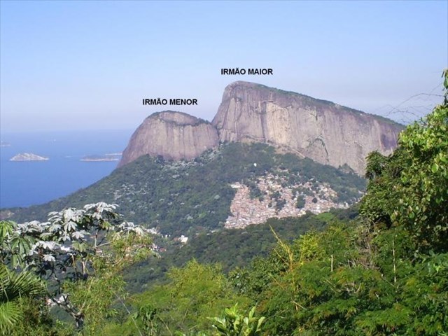
Morro Dois Irmãos
The published coordinates should bring you to the top to the "Big Brother" - Irmão Maior!
Morro Dois Irmãos ( Two Brothers Mountain) is one of the most beautiful symbols of Rio de Janeiro. The mountain rises inside the South Zone, between Leblon and São Conrado beaches. The best place to see the majestic form of this mountain is from Ipanema, but Lagoa Rodrigo de Freitas offer an impressive view of the mountain too. Close to beaches, buildings, shopping centers and streets, this mountain is surrounded by two poor communities called “favelas”. Vidigal and Rocinha surround the mountain by North, West and South sides, ruining the image.
There are 2 mountains in one massif : Irmão Maior and Irmão Menor
Origin
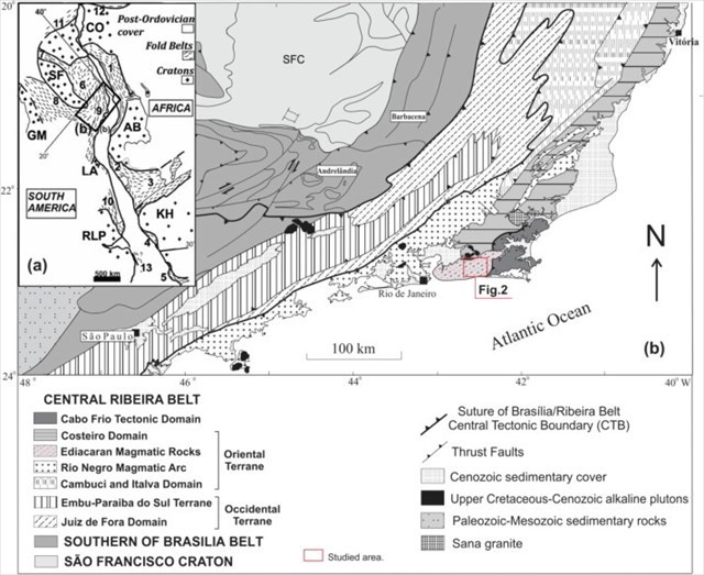
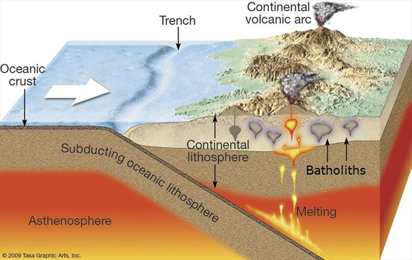
The region where the Pedra da Gávea is located is part of the geotectonic entity Atlantic Orogenic Belt or Ribeira Belt. The geological ladscapes making up this orogeny correspond to geological structures produced by the processes of convergence of the active margins of the brasilianos / pan-African tectonic plates. During the Neoproterozoic era, between 1 billion and 540 million years ago, several continental plates collided and stuck together creating the Gondwana super-continent. This continent would last until the end of the Paleozoic era, concentrating all land situated in the southern hemisphere. Between African and South American plates existed a paleo-ocean called Adamastor. With the continental plates movement towards each other, the oceanic lithosphere - the Adamastor ocean floor - was subducted under continental plates. Neoproterozoic rocks created during this orogeny are the result of subduction events during the convergence, collision and sticking of the active margins of the Brasilianos / Pan-African tectonic plates. The subduction process of the oceanic floor enabled the ascent of magma close to the active continental margins and resulted in granitic intrusions and placement of several granitoid bodies of various sizes inside the continental plate. The magma intruded and crystallized at great depths in earth's crust creating many rocky bodies between 500 and 490 million years ago. The Rio de Janeiro batholith (Sugar Loaf and Corcovado) - is a testament to the collage of continental plates that made up the Brasilianos / Pan-African orogenies at the south continental margin of South America and Africa. The accurate dating of this sincolisional arc in 560 millon years provided the most consistent estimate for the age of amalgamation of the super-continent Godwana.
After a long period of tectonic stability in the Paleozoic and early Mesozoic, the super-continent Gondwana began to fragment and approximately 135 to 110 million years ago Brazil and Africa began to separate with the opening of the Atlantic Ocean. As the process continued South America has been gradually separating from Africa and North America from Europe, giving rise to the Atlantic Ocean and the mid-oceanic ridge, formed by submarine volcanic floods. This fragmentation was accompanied by a broad uplift of the entire eastern edge of the newly created South America continent and the western edge of Africa. The volcanic floods and rocks located below were topographically elevated forming what was later termed as Serra do Mar and Serra Geral. Thus, the Serra do Mar had its origin in the Cretaceous tectonic movements that promoted a massive elevation of the edge of the continent and the lowering of adjacent blocks generating the Guanabara Graben. The Guanabara Graben constitutes an elongated rift valley bordered by higher areas corresponding to the coastal mountains of Rio de Janeiro and the escarpment of the Serra do Mar.
Questions:
To log this earthcache, please email the answers to the following questions at the same time as you log your find. If there is a problem with any of the answers. I will let you know. Found logs will be deleted if answers are not emailed at the same time.
1) At the posted coordinates look around, what type of rocks can you identify there?
2) What kind of geological processes made the shape of these mountains?
3) Estimate and tell me, what is the altitude at top of the mountain (given coordinates)?
4) At the top the Irmão Maior (at the GZ), there is a little monument which symbolizes highest place of the mountain. Estimate the height of that little monument and tell me, from what kind of material it is made.
5)Take a photo of yourself or with your GPS device on top of the Irmão Maior mountain!