🌎 Dolinas Gêmeas EarthCache
-
Difficulty:
-

-
Terrain:
-

Size:  (other)
Please note Use of geocaching.com services is subject to the terms and conditions
in our disclaimer.
Earthcache é simples:
Visitar o local, Ler a página do cache, Responder as perguntas para o owner (não no log) e então Registrar... Qualquer dúvida entre em contato
Earthcache is simple:
Visit the site, Read the cache page, Answer the questions for the owner (not in the log) and then Register... Any questions please contact us
Os Campos Gerais são privilegiados pela sua geografia peculiar. Arenitos, crateras e cachoeiras que vão muito além de Vila Velha
-Local sem infraestrutura, propriedade particular, acesso permitido
-Tem como descer a pé dentro de uma das furnas, mas cuidado! Na outra só através de rapel
-Recomendável o acompanhamento de alguém que conheça o local.
Acesso pela Rodovia do Talco. No Km 18,6, a partir do Campus Uvaranas da UEPG, logo após o vilarejo do Passo do Pupo, deve-se virar à direita numa estrada não pavimentada. Deve-se percorrer mais 700 m até onde está o acesso às Furnas Gêmeas, que se faz por meio de um “mata burro” localizado próximo à cerca da propriedade
 Dolina
É uma depressão ocasionada pela dissolução da rocha em regiões calcárias ou pelo desmoronamento consequente de tais dissoluções. Se o teto de uma caverna perder sua resistência e desabar, provocará na superfície do terreno depressões cujo tamanho pode ser considerável e cuja forma se assemelha ás vezes a verdadeiros funis
As furnas de Ponta Grossa são grandes crateras no terreno, denominadas por Maack (1956 e 1968) e Soares (1989) como poços de desabamento que apresentam dezenas de metros de diâmetro e profundidade que atingem mais de uma centena de metros. No município de Ponta Grossa são reconhecidas 13 furnas, mas destaca-se a ocorrência de diversas depressões no terreno e dolinas em formação, apresentando medidas inferiores a 10 metros de profundidade. Estas feições, como também outras geoformas do relevo, tais como: sumidouros e ressurgências (drenagem subterrânea); lagoas; túneis; caneluras; lapiés; bacias de dissolução (kamenitzas), alvéolos e túneis anastomosados, cúpulas e dutos de dissolução, espeleotemas, panelas e diversas cavidades subterrâneas, são consideradas como feições resultadas do processo de carstificação da rocha.
A região dos Campos Gerais possui várias feições no relevo desenvolvidas sobre os arenitos da Formação Furnas (Siluriano/Devoniano), pode ser classificado como um relevo cárstico não carbonático
Furnas Gêmeas (nome oficial Furna do Passo do Pupo 1 e 2)
A Furna Passo do Pupo 1 apresenta 93 metros de diâmetro em seu eixo maior e 47 metros em seu eixo menor. Sua profundidade total é de 38 metros e nota-se que em seu interior há uma área mais profunda situada em sua porção oeste, apresentando um desnível de 15 metros entre uma porção e outra. Foram identificadas visualmente oito fendas e fraturas presentes nesta furna.
A Furna Passo do Pupo 2 é menor em relação ao diâmetro do que a Furna 1, mas a supera em desnível. Seu diâmetro no eixo maior possui 82 metros e no eixo menor apresenta 44 metros, a furna apresenta 53,6 metros de profundidade. Foram observadas 8 fendas e fraturas em seu interior.
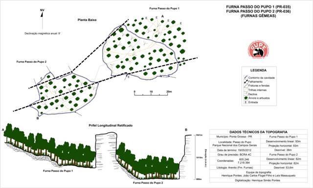 |
| Mapeamento morfoestrutural das Furnas Gêmeas |
Processo de formação
As Furnas Gêmeas estão controladas por um falhamento de direção geral N70°E, o qual condiciona a morfologia das feições em questão, bem como influencia na formação das outras dolinas do Município de Ponta Grossa.
Considera-se que o processo de formação das furnas é coincidente aos fatores condicionantes para a ocorrência de dolinas em área carbonáticas: permeabilidade condicionada, sobre tudo, por fraturas na rocha; dissolução das águas subterrâneas e superficiais e; desabamento de blocos de rocha. Tais processos ocorrem em fases distintas (períodos de tempo), mas a formação final desta feição (com o formato que se visualiza no presente), é caracterizada pela ação conjugada de diferentes momentos da dinâmica do carste em questão.
Além da influência das rochas carbonáticas, o processo de dissolução também ocorre no corpo do arenito, apresentando quatro momentos distintos da gênese, sendo eles: o primeiro momento da gênese está relacionado a processos tectônicos que geram permeabilidade por fratura na rocha; o segundo momento é caracterizado por processos hipogenéticos (processos originados em ambiente confinado), caracterizado pela erosão de águas subterrâneas e consequente alargamento de dutos, canais e descontinuidades da rocha; no terceiro momento, com o rebaixamento do nível freático regional e exumação do relevo em superfície, inicia-se o processo de formação de depressões no terreno e desabamento de blocos no interior de cavidades subterrâneas concomitantemente; o quarto e último estágio é o desabamento completo do teto da cavidade subterrânea, originando assim a dolina.
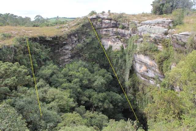 |
| Furna Gêmea 2, As linhas amarelas indicam os dois falhamentos, ressaltando que a porção central entre as duas falhas foi rebaixada |
Se você visitou este local e leu corretamente a descrição pode fazer o log no Earthcache, envie as respostas via Message this owner, se elas porventura não estiverem corretas eu entrarei em contato
Questões:
1- O que é uma dolina? Olhando do ponto superior onde se encontra este earthcache é possível confirmar que se trata de uma dolina?
2- Quanto ao Processo de formação, quais os quatro momentos distintos da gênese que origina a dolina?
3- O desabamento do teto e a formação da cavidade formam diferentes características dos dois terrenos, petrologia, solo, clima etc...
A vegetação desenvolve-se conjuntamente à essas características e há uma notável diferença entre a vegetação do interior da dolina (arbórea de maior porte) e a da parte superior (rasteira e herbácea).
Descreva o terreno da parte superior da dolina.
4- Queria pedir também uma foto sua no local (opcional)

The Campos Gerais are privileged by their peculiar geography. Sandstone, craters and waterfalls that go far beyond Vila Velha
-Local without infrastructure, private property, access allowed
-You can walk down into one of the caverns, but be careful! In the other only by abseiling
-Recommended the accompaniment of someone who knows the place.
Access by Rodovia do Talco. At Km 18.6, from UEPG Campus Uvaranas, just after the village of Passo do Pupo, you should turn right onto an unpaved road. One should go another 700 m to where is the access to the Furnas Gêmeas, which is done by means of a "barrier" located near the property fence
Doline (sinkholes)
It is a depression caused by the dissolution of the rock in calcareous regions or by the consequent collapse of such dissolutions. If the roof of a cave loses its resistance and collapses, it will cause on the surface of the ground depressions whose size can be considerable and whose shape sometimes resembles true funnels
The "Furnas of Ponta Grossa" are large craters in the ground, called by Maack (1956 and 1968) and Soares (1989) as wells of collapsed that are tens of meters of diameter and depth that reach more than a hundred meters. In the municipality of Ponta Grossa 13 fountains are recognized, but it is worth noting the occurrence of several depressions in the terrain and dolines in formation, presenting measurements inferior to 10 meters of depth. These features, as well as other geoforms of the relief, such as: sinks and resurgences (underground drainage); lagoons; tunnels; fluting; laps; (kamenitzas), alveoli and anastomosed tunnels, domes and dissolution ducts, speleothems, pots and several underground cavities, are considered as features resulting from the process of rock carvings.
The Campos Gerais region has several relief features developed on the sandstones of the Furnas Formation (Silurian / Devonian), can be classified as a non-carbonate karst relief
Furnas Gêmeas (official name Furna do Passo do Pupo 1 and 2)
Furna Passo do Pupo 1 presents 93 meters in diameter on its major axis and 47 meters in its minor axis. Its total depth is of 38 meters and it is noticed that in its interior there is a deeper area located in its west portion, presenting a drop of 15 meters between one portion and another. Eight slits and fractures were identified visually in this furna
The Furna Passo do Pupo 2 is smaller in relation to the diameter than Furna 1, but it surpasses in unevenness. Its diameter in the major axis has 82 meters and in the minor axis presents 44 meters, the cave presents 53.6 meters of depth. Eight slits and fractures were observed inside.
|
| Morphostructural mapping of the Furnas Twin |
Formation process
The Twin Furnas are controlled by a fault of general direction N70 ° E, which conditions the morphology of the features in question, as well as influence in the formation of the other dolines of the Municipality of Ponta Grossa.
It is considered that the furnas formation process is coincident with the conditioning factors for the occurrence of dolinas in the carbonate area: permeability conditioned, above all, by fractures in the rock; dissolution of groundwater and surface water; collapse of rock blocks. These processes occur in distinct phases (periods of time), but the final formation of this feature (with the format that is visualized in the present), is characterized by the conjugated action of different moments of the karst dynamics in question.
In addition to the influence of carbonate rocks, the dissolution process also occurs in the body of the sandstone, presenting four distinct moments of the genesis, being: the first moment of the genesis is related to tectonic processes that generate permeability by fracture in the rock; the second moment is characterized by hypogenetic processes (processes originated in a confined environment) characterized by the erosion of groundwater and consequent enlargement of ducts, channels and discontinuities of the rock; in the third moment, with the lowering of the regional water table and exhumation of the surface relief, the process of formation of depressions in the ground begins and collapses of blocks inside underground cavities concomitantly; the fourth and last stage is the complete collapse of the ceiling of the underground cavity, thus originating the doline.
|
| Furna Twin 2, The yellow lines indicate the two faults, emphasizing that the central portion between the two faults has been lowered |
If you have visited this site and read the description correctly you can log on to Earthcache, send the responses via Message this owner, if they are not correct I will contact you
Questions:
1- What is a doline? Looking from the top spot where this earthcache is, is it possible to confirm that it is a sinkhole?
2- Regarding the process of formation, what are the four distinct moments of the genesis that originates the doline?
3 - The collapse of the ceiling and the formation of the cavity form different characteristics of the two lands, petrology, soil, climate, etc...
The vegetation develops along these characteristics and there is a notable difference between the vegetation of the interior of the dolina (larger tree) and that of the upper part (herbaceous).
Describe the terrain at the top of the sinkhole.
4- I also wanted to ask for a photo of you on the spot (optional)
Translated by Google
If anyone has a suggestion for improving this, please contact
|
Geo Hugs
|
|

|
Additional Hints
(No hints available.)