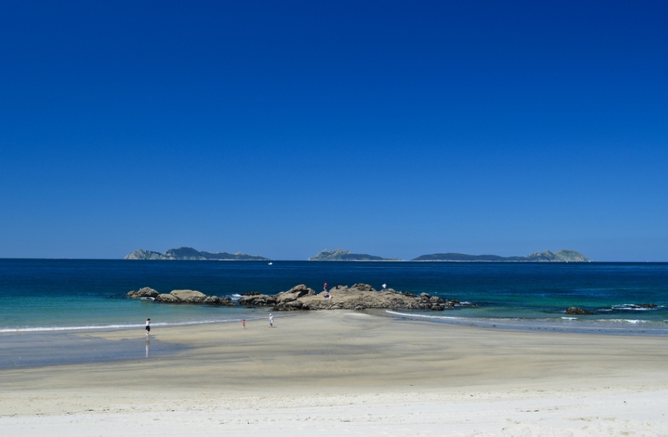
Playa de Samil EarthCache
-
Difficulty:
-

-
Terrain:
-
Size:  (other)
Please note Use of geocaching.com services is subject to the terms and conditions
in our disclaimer.
Samil es la playa urbana de Vigo, y por lo tanto su entorno se configura como el litoral lúdico de la ciudad, en contraste con la fachada costera del centro, ocupada por instalaciones portuarias en su práctica totalidad. La relativa separación del centro urbano la ha librado, hasta cierto punto, de implantaciones de mayor calado, especializándose en los usos residencial unifamiliar y terciario. Estas circunstancias convierten al área de Samil en un ámbito con una clara vocación de acoger.
Las unidades litologicas
Aunque las granodioritas con megacristales feldespáticos, que forman parte de los granitoides de afinidad alcalina en fase precoz, son dominantes en esta unidad, existen dos bandas de granitos de afinidad alcalina (granito con feldespato alcalino) que las atraviesa de sur a norte: una llega prácticamente a la Punta do Muíño, mientras que la otra ocupa el sureste de la unidad. Sobresalen los campos dunares y las masas de arena de playa depositadas en torno a la Enseada de Samil. Los primeros se prolongan hacia el norte hasta alcanzar la playa da Fonte.
Pendiente y formas
La pendiente de la playa es moldeada por la acción del oleaje, siendo este el principal agente de cambio en la forma de la playa, pero no el único (el viento, el hombre, etc.). Se dice que cuando una playa tiene una pendiente inclinada está en o cerca de tener un perfil de verano, el cual presenta la acumulación de sedimentos tanto en la cara de la playa como en la parte de atrás de la misma. Dando paso a la formación del berma, acumulación característica del perfil de verano. Del mismo modo para invierno se forma el perfil de invierno o perfil disipado, en donde la pendiente de la playa es suave o casi plana. Donde la gran mayoría de los sedimentos se han transportado hacia la playa submarina formando la fosa y la barra. Debe de tenerse en cuenta que las playas se desarrollan en costas bajas..
Partes de una playa
Dentro de una playa ideal se pueden distinguir tres ambientes sedimentarios distintos, caracterizados cada uno de ellos por presentar un tipo de material asociado a unas estructuras sedimentarias primarias determinadas. El subambiente más proximal o que limita con el cordón de dunas es el llamado backshore (zona supramareal), cuyo límite inferior lo constituye el nivel de marea alta. Hacia el mar le sigue el foreshore (zona intermareal), que ambientalmente, aunque con sedimentos y morfología de fondo distintos correspondería al intramareal; o sea, que sus límites superior e inferior lo constituyen, respectivamente, el de marea alta y el de marea baja. La parte más distal de una playa la forma el shoreface (zona inframareal), siempre bajo las aguas, que se halla delimitado entre el nivel de marea baja y el punto donde el oleaje deja de ejercer una acción sobre el fondo. A partir de este punto, de situación algo imprecisa, se desarrolla el área de sedimentación de los materiales de plataforma, también conocida como offshore. Los materiales típicos depositados en una playa son las arenas. No obstante, tanto en formaciones actuales como fósiles abundan las playas de cantos rodados. Las laminaciones son más o menos típicas para cada una de las zonas. Backshore Es el área que tan sólo forma parte del ambiente marino durante los grandes temporales, que es cuando las aguas la cubren. Es característico de esta zona la existencia de pequeños escalones llamados bermas, producidos por temporales. Los materiales que se depositan en esta zona son fundamentalmente arenosos. La proporción de limo no rebasa el 10%. (En las dunas costeras prácticamente el 100% es arena.) Los fósiles que allí se hallen serán siempre retrabajados Puede existir también una débil bioturbación de los materiales. Es un subambiente difícil de caracterizar por sí solo en series estratigráficas. Para ello debe conocerse la sucesión de ambientes en sentido vertical y lateral. Esto se debe a que los materiales transportados por el mar son retrabajados generalmente por el viento, y, por lo tanto, se pueden encontrar diferentes tipos de estructuras sedimentarias. Las más comunes son la laminación paralela, a veces ripples de corriente y, con menor frecuencia, una laminación cruzada de bajo ángulo. Foreshore Es la parte que puede ser considerada como la playa propiamente dicha. Diariamente participa del continente y del mar al ritmo marcado por las mareas. Los materiales que se depositan en esta zona son arenosos (la proporción de limo es también pequeña), aunque la clasificación es menor a la que presentan las arenas del backshore y de las dunas costeras. Las capas presentan una laminación cruzada planar típica de pequeño ángulo. Las láminas poseen generalmente una relativa gran longitud. Estas buzan en dirección al mar y en realidad corresponden a verdaderas superficies de acreción. Son frecuentes los ripples debidos a olas, tanto los simétricos como los asimétricos, aunque generalmente no se conservan en sedimentos fósiles. En la parte más distal del foreshore pueden crecer longshore bars, o barras que poseen un perfil asimétrico. Pueden migrar, aparecer o desaparecer con mucha facilidad. Es un área de acumulación relativa de conchas muertas. El sedimento puede hallarse parcialmente bioturbado con burrows, por lo general en posición vertical. Shoreface Si bien el límite superior del shoreface queda morfológicamente y hasta cierto punto sedimentológicamente bien establecido, el límite inferior es muy impreciso. Anteriormente se ha dicho que se considera como tal aquel punto en que el oleaje deja de actuar sobre el fondo en los períodos de buen tiempo. Este límite, desde un punto de vista sedimentológico, podria ser establecido en el límite arena-limo. En el shoreface los sedimentos son aún dominantemente arenosos mientras en la plataforma son arcillosos. Corresponde, por consiguiente, a una zona de transición en cuanto a la granulometría de los materiales. No obstante, en esta área existen dos tipos de estructuras sedimentarias muy características. Por un lado, la existencia de ripples de olas con las crestas alineadas paralelamente a la costa, ya sean simétricos ya asimétricos, a pequeña o gran escala (megaripples). Por el otro, debe pensarse que es un área con un gran dominio de vida, aparte de incluir una abundante fauna, los sedimentos, localmente se hallarán bioturbados por completo. Al igual que en la zona de foreshore pueden presentarse barras alineadas sensiblemente paralelas a la línea de costa. Estas barras poseen el flanco de sedimentación orientado hacia la costa. Como en el caso anterior, migran con mucha facilidad.
Ciclos de una playa
En un caso ideal y en una costa progradante que dé lugar, por lo tanto, a una serie regresiva, la superposición de subambientes de playa debe ser como sigue: En la parte alta del ciclo existirán depósitos de dunas eólicas costeras y que marcarán el fin del ciclo. Luego, sucesivamente, la serie estará formada por depósitos de backshore, de foreshore y de shoreface. El ciclo comenzará normalmente sobre un sustrato formado por sedimentos de plataforma continental (offshore).. Esto no siempre se observa en el campo, pues estos ciclos pueden ser incompletos, ya sea debido a la erosión, ya a la fuerte subsidencia que actúa en la zona y que no permite el desarrollo completo del ciclo. Si la serie es transgresiva, lógicamente la distribución de medios es a la inversa de cómo se han establecido anteriormente. Aunque en este caso, por lo general, los ciclos son aún más incompletos.
Formación de una playa
Para que se forme una playa debe haber ciertas condiciones que lo permitan. Primero debe existir un área geomórfica que permita la acumulación de sedimentos. Segundo, debe ser mayor la acumulación o acreción de sedimentos que la erosión, ya que si la segunda es mayor, no habrá una acumulación permanente. Recordemos que toda playa ha alcanzado naturalmente un cíclo entre la acreción y erosión. Sin embargo, si se insertan nuevas variables que afecten esta relación se puede sobrepasar el límite geomórfico de la playa y desencadenar una serie de eventos que pueden llevar a la pérdida de la playa. El tamaño del sedimento va a depender de la fuerza del oleaje en la playa. Si es una playa de alta energía, por lo general el sedimento va a ser grueso. Mientras que en playas de energía baja o media baja, los sedimentos van a ser finos y medios, aunque puedan presentar clastos debido a la acción de temporales y marejadas. La playa es una formación geomórfica dinámica y cambiante, que está en permanente cambio. Están sujetas a cambios extraordinarios generados por la acción del oleaje, los eventos climáticos (tropicales y extratropicales), la acción del hombre, etc. Por eso no se puede decir que se fue dos veces a la misma playa, ya que la playa de hoy es diferente de la de ayer y mañana. El término "playa" también tiene una acepción a menudo empleada en los textos de Geografía y Geología para designar a los bordes fluctuantes de lagos salobres, salinos o de "salares" propiamente dichos. Es un término muy frecuente en México y el Oeste de los Estados Unidos. Estos lagos salinos o "salares" suelen presentarse en cuencas endorreicas o depresiones de escasa profundidad donde la evaporación es muy intensa, por lo que se van acumulando las sales, al precipitarse, en el fondo de las mismas.
La playa como habitat
Una playa es algunas veces un entorno inestable que expone a las plantas y animales que lo habitan a condiciones siempre cambiantes. Sin embargo, esos patrones cíclicos diarios y estacionales llevan a numerosos organismos vegetales y animales las fuentes de alimentación y de supervivencia. Algunos pequeños animales hurgan en la arena y se alimentan con el material depositado por las olas. También la habitan cangrejos, insectos y pequeños pájaros. Los restos de animales muertos y algas depositados en la zona superior de la playa y dunas hace posible la aparición de una tímida vegetación compuesta por matas y otras flores.
Para poder registrar este earthcaché deberás enviarnos las respuestas a las siguientes preguntas:
1- Explica con tus palabras como se forma una playa
2- ¿Cuántos metros de "foreshore" hay en esta playa? (puedes utilizar tu móvil/GPS para calcularlo)
3- Que tipo de bandas de granito existen en Samil y cual es la dominante.
4- De que tipo de piedra está construido la pared del muro que delimita la playa de Samil de su paseo?
5- Opcional, pon una foto sin revelar ninguna respuesta
Samil is the urban beach of Vigo, and therefore its environment is configured as the ludic coastline of the city, in contrast to the coastal front of the center, occupied by port facilities in its entirety. The relative separation of the urban center has freed it, up to a certain point, from larger deployments, specializing in single-family and tertiary residential uses. These circumstances make the Samil area an area with a clear vocation to welcome.
The lithological units
Although the granodiorites with feldspathic megacrystals, which are part of the alkaline affinity granitoids in the early phase, are dominant in this unit, there are two bands of granites of alkaline affinity (granite with alkali feldspar) that crosses them from south to north: one arrives practically to Punta do Muíño, while the other occupies the southeast of the unit. The dune fields and the masses of sand of the beach deposited around the Enseada de Samil stand out. The first ones extend towards the north until reaching the beach of Fonte.
Earring and shape
The slope of the beach is shaped by the action of the waves, being this the main agent of change in the shape of the beach, but not the only one (wind, man, etc.). It is said that when a beach has a sloping slope it is at or near to have a summer profile, which presents the accumulation of sediments both on the beach face and on the back of the beach. Giving way to the formation of the berm, characteristic accumulation of the summer profile. In the same way for winter is formed the winter profile or dissipated profile, where the slope of the beach is smooth or almost flat. Where the vast majority of the sediments have been transported to the submarine beach forming the pit and the bar. It should be noted that the beaches are developed on low coasts.
Parts of a beach
Within an ideal beach three distinct sedimentary environments can be distinguished, each one characterized by presenting a type of material associated with certain primary sedimentary structures. The most proximal sub-area or border with the dune cord is the so-called backshore (supramareal zone), whose lower limit is the high tide level. Towards the sea is followed by the foreshore (intertidal zone), which environmentally, although with different background sediment and morphology correspond to the intratidal; that is, its upper and lower limits are respectively the high tide and the low tide. The most distal part of a beach forms the shoreface (inframareal zone), always under the waters, that is delimited between the level of low tide and the point where the wave stops to exert an action on the bottom. From this point, of somewhat imprecise situation, the sedimentation area of the platform materials, also known as offshore, is developed.
The typical materials deposited on a beach are the sands. However, both in today's formations and fossils, the beaches of boulders abound. The laminations are more or less typical for each of the zones.
Backshore
It is the area that is only part of the marine environment during the great storms, which is when the waters cover it. It is characteristic of this zone the existence of small steps called berms, produced by temporary. The materials deposited in this area are essentially sandy. The proportion of slime does not exceed 10%. (In the coastal dunes practically 100% is sand.) The fossils that are there will always be reworked. There may also be a weak bioturbation of the materials. It is a sub-environment difficult to characterize by itself in stratigraphic series. For this, the sequence of environments in the vertical and lateral senses must be known. This is because the materials transported by the sea are generally reworked by the wind, and, therefore, different types of sedimentary structures can be found. The most common are parallel lamination, sometimes ripples of current and, less frequently, cross-lamination of low angle.
Foreshore
It is the part that can be considered as the beach proper. Daily it participates of the continent and of the sea to the rhythm marked by the tides.
The materials that are deposited in this zone are sandy (the proportion of silt is also small), although the classification is smaller than the one presented by the sands of the backshore and the coastal dunes.
The layers present a typical planar cross-lamination of small angle. The blades generally have a relatively large length. These swim towards the sea and actually correspond to true accretion surfaces. Ripples due to waves are frequent, both symmetrical and asymmetrical, although they are generally not conserved in fossil sediments.
In the most distal part of the foreshore can grow longshore bars, or bars that have an asymmetrical profile. They can migrate, appear or disappear very easily.
It is an area of relative accumulation of dead shells. The sediment may be partially bioturbated with burrows, usually upright.
Shoreface
Although the upper limit of the shoreface remains morphologically and to some extent sedimentologically well established, the lower limit is very imprecise. Earlier it has been said that it is considered as such a point where the wave stops acting on the bottom in periods of good weather. This limit, from a sedimentological point of view, could be established at the sand-limo boundary. In the shoreface the sediments are still dominantly sandy while in the platform they are clayey. It corresponds, therefore, to a transition zone in terms of the granulometry of the materials. However, in this area there are two types of very characteristic sedimentary structures. On the one hand, the existence of ripples of waves with crests aligned parallel to the coast, whether symmetric or asymmetrical, to small or large scale (megaripples). On the other hand, it must be thought that it is an area with a great domain of life, besides including an abundant fauna, the sediments, locally they will be completely bioturbated. As in the foreshore area can be presented aligned bars that are substantially parallel to the coastline. These bars have the sedimentation flank facing the coast. As in the previous case, they migrate very easily.
Beach Cycles
In an ideal case and on a progrant coast that gives rise, therefore, to a regressive series, the overlap of beach subambientes should be as follows: In the upper part of the cycle there will be deposits of coastal wind dunes and that will mark the end of the cycle. Then, successively, the series will be formed by deposits of backshore, foreshore and shoreface. The cycle will normally begin on a substrate formed by offshore sediments.
This is not always observed in the field, because these cycles may be incomplete, either due to erosion, or to the strong subsidence that acts in the area and that does not allow the complete development of the cycle.
If the series is transgressive, logically the media distribution is the reverse of how they were established earlier. Although in this case, the cycles are usually even more incomplete.
To form a beach there must be certain conditions that allow it. First there must be a geomorphic area that allows the sediment to accumulate. Second, sediment accumulation or accretion must be greater than erosion, since if the second is larger, there will be no permanent accumulation. Remember that every beach has naturally reached a cycle between accretion and erosion. However, if you insert new variables that affect this relationship you can surpass the geomorphic limit of the beach and trigger a series of events that can lead to the loss of the beach.
The size of the sediment will depend on the strength of the waves on the beach. If it is a high energy beach, the sediment will usually be thick. While on low or medium low energy beaches, the sediments will be fine and medium, although they may present clasts due to the action of storms and tidal waves.
The beach is a dynamic and changing geomorphic formation, which is constantly changing. They are subject to extraordinary changes generated by the action of the waves, the climatic events (tropical and extratropical), the action of the man, etc. That's why you can not say that he went twice to the same beach, since today's beach is different from yesterday's and tomorrow's.
The term "beach" also has a meaning often used in the texts of Geography and Geology to designate the fluctuating borders of brackish, saline lakes or "salares" proper. It is a very frequent term in Mexico and the West of the United States. These saline lakes usually present in endorheic basins or depressions of low depth where the evaporation is very intense, reason why the salts are accumulating, when precipitating, in the bottom of the same ones. The beach as a habitat
A beach is sometimes an unstable environment that exposes the plants and animals that inhabit it to ever changing conditions. However, these daily and seasonal cyclical patterns lead to numerous plant and animal organisms the sources of food and survival. Some small animals pound in the sand and feed on the material deposited by the waves. Crabs, insects and small birds also inhabit it. The remains of dead animals and algae deposited in the upper part of the beach and dunes make possible the appearance of a timid vegetation composed of woods and other flowers.
In order to register this earthcache you should send us the answers to the following questions:
1-Explain with your words how a beach is formed
2- How many meters of foreshore is there on this beach? (you can use your mobile / GPS to calculate it)
3- What type of granite bands exist in Samil and which is the dominant one.
4-What type of stone is the wall that delimits the Samil beach of our ride?
5-Optional, put a photo without revealing any answer
Additional Hints
(No hints available.)