FRENCH
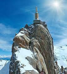
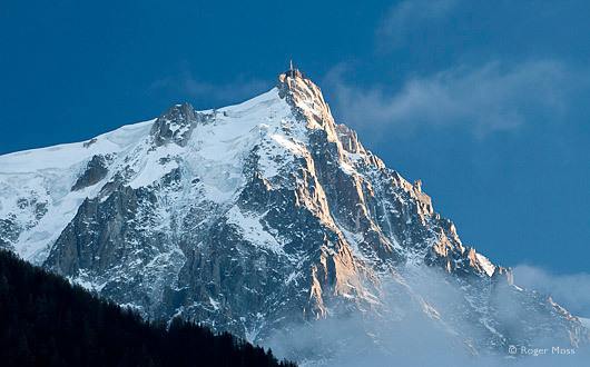
Le Mont Blanc près de l'Aiguille du Midi est le sommet le plus élevé du massif du Mont Blanc à 4810 m et continue de monter chaque année de l'ordre de 2 mm selon le soulèvement de la plaque tectonique.
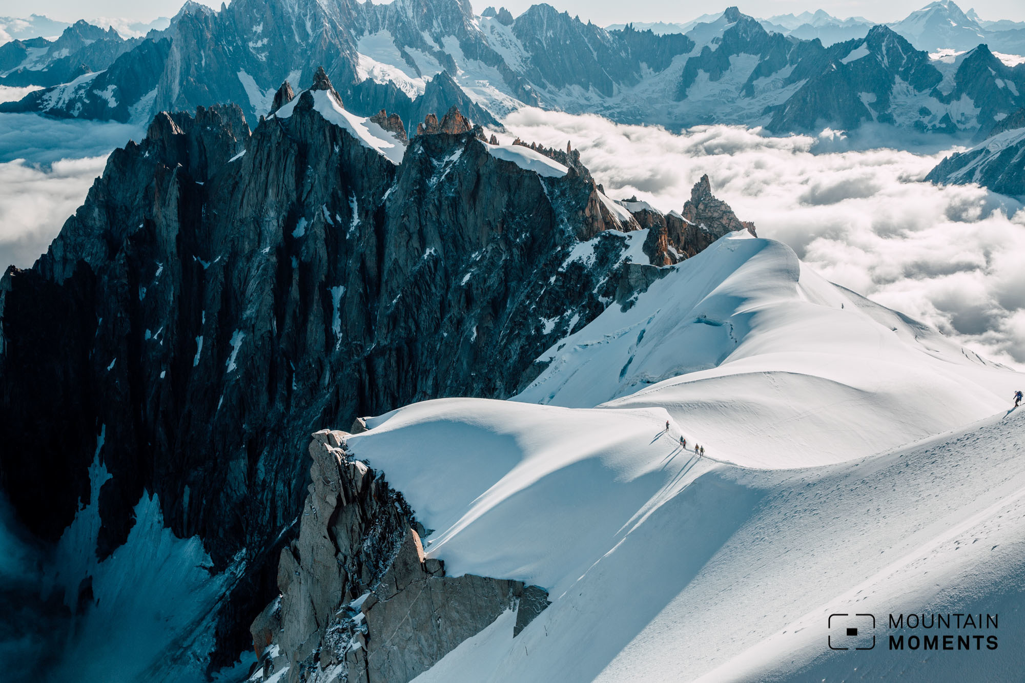
Le substratum rocheux du massif du Mont Blanc se compose de roches cristallines avec des sédiments superposés lors du secondaire et du tertiaire. Le paysage actuel s'est formé lors des plis et des failles de l'oligocène. Il existe plusieurs types de roches : granite, gneiss, granite à biotite, schiste et amphibolite. Divers sédiments peuvent s'observer dans la partie inférieure du massif.
Le massif du Mont-Blanc s'allonge du nord-est au sud-ouest dans la chaîne alpine nord occidentale. Il évolue en plein accord avec l'orientation actuelle des forces internes à la planète qui rapprochent les plaques européenne et africaine, cette dernière étant représentée par la plaine du Pô. Le massif du Mont-Blanc s'étire donc au contact de ces deux plaques. Sa diversité par rapport aux reliefs environnants vient du matériel dont il est constitué. Sa roche magmatique est née dans les entrailles surchauffées d'ne plaque continentale. Bien que parcouru par un réseau de fractures, notre massif garde la cohésion d'un bloc rigide. En répondant aux sollicitations internes du système alpin, il ne s'est pas plissé comme les roches sédimentaires environnantes, mais il a pris une forme d'amande. Son isolement dérive de sa surrection au milieu de terrains charriés et plissés. À l'avant, vers la Vallée d'Aoste, le Mont-Blanc a rencontré l'ancien front de chevauchement qui poussait les deux plaques à se superposer. Le sillon à son pied indique le début du plan incliné souterrain à partir duquel la plaque européenne glisse sous la châine alpine. À l'arrière, vers la Savoie, la surface se froisse comme un tapis glissant contre un obstacle. Bousculé par les Aiguilles-Rouges et coincée derrière le Mont-Blanc, la vallée de Chamonix est un exemple de ces déformations.
Pour enregistrer cette cache de la terre, veuillez répondre aux questions suivantes :
- Quelle est la hauteur au-dessus du niveau de la mer indiquée sur votre GPS ? N'oubliez pas de régler votre hauteur de référence, p. ex. à la station téléphérique dans la vallée ! Et expliquez-moi ce qui fait monter la chaîne alpine
- Sortez à l'extérieur, ou, en cas de mauvaise météo, entrez dans un des tunnels où vous observer observateur le substratum rocheux. Décrire ce substrat (forme des grains, taille des grains, couleur générale de la roche, ..), mentionner si la pierre est magmatique (ex granit) ou sédimentaire et expliquer comment ils ont été formés.
- Si vous le désirez (FACULTATIF) - prenez une photographie de vous-même OU de votre GPS au sommet de l'Aiguille du Midi et l'ajouter en pièce jointe avec votre entrée dans le journal. En cas de mauvaise météo, nous vous proposons de prendre votre photographie à l'intérieur et de montrer un élément typique (soyez créatifs !).
Ecrivez directement dans le journal et ensuite, veuillez me faire parvenir vos réponses à mon compte à : geocaching.com ou email dunaghiri@hotmail.com - Je vous tiendrai informé en cas de soucis.
Bonne journée à tous et bon voyage !
ENGLISH
The Mont Blanc near the Aguille du Midi is the highest peak in the Mont Blanc Massif with 4810m and it is still growing with an everage rate of 2 mm / year due to uplift of the whole tectonic plate.
The base of the Mont Blanc Massif is old crystalline bedrock which is overlain by sediments during the Mesozoic and Tertiary. Folding and faulting during the Oligocene formed the actual landscape. There are several rock types: Granite, gneiss, biotitegranite, schist and amphibolite. In the lower areas of the massif there are also some sediments.
Mont Blanc extends from north-east to south-west in the north-western Alpine chain. It therefore evolves in complete harmony with the current direction of the internal powers of the Planet, that tend to bring the European plate closer to the African one, the latter represented by the Padana Plain. Mont Blanc therefore lengthens following the contact points of the continental plates. Its isolation derives from the fact that it rises in the middle of a region with prevailing subsidence. At the feet of the mountain, towards the Valle d'Aosta (Aosta Valley), is the underground sloped plain that caused the European plate to submerge under the Alpine chain. Towards Savoie the European continental crust folds like a mat when it slides against an obstacle. Pushed on its shoulders by the Aiguilles Rouges and blocked behind Mont Blanc, the Chamonix valley narrows following this disforming model.
Its diversity from the surrounding relief comes from the material it is made of. Its rock was formed from a bubble of magma in the overheated bowels of a continental plate. Even though a network of fractures runs through it, the massif maintains the cohesion of a rigid block. Answering the internal stress of the system, it did not crumble or fold like the sedimentary rocks around it, but only took on an almond shape.
To log this Earthcache, please answer the following questions:
1. What height above sea level does your GPS show? Don't forget to put it to the right basis height at e.g. the cable car station down at the valley! And explain to me what causes the Alpine chain to rise
2. Go outside the station or if the weather is bad go inside one of the tunnels where you can see the bedrock. Describe this bedrock (grain form, grain size, grain colours, overall colour of rock, ...) and try to decide whether this rock is sedimentary or igneous (e.g. granite) and explain how the were formed.
3. Please take - if you like, this is OPTIONAL - a photo of you OR your GPS at the top of the Aiguille du Midi and attach it to your logentry. If there is bad weather, you can take this photo inside the buildings and show something characteristic (just be creative and flexible with this point).
You can make your log entry directly and after doing it, please send the answers via messenger here at geocaching.com or mail me at dunaghiri@hotmail.com- I will tell you, if there is something wrong.
I would like to wish all of you a good day and a safe trip!
