Le pli en champignon de la Cernaise
Le Jura possède de nombreux sites nous présentant le style tectonique jurassien, l’un des plus connus est celui du Chapeau de Gendarme, non loin d'ici...

Mais il y a aussi le pli en champignon de la Cernaise, son cousin, que vous allez découvrir à travers cette earthcache...
Il s'agit d'un géosite doublement remarquable à vocation géologique témoignant des actions tectoniques lors de la mise en place de la Haute-Chaîne Jurassienne, mais également à vocation géomorphologique locale témoin de la dernière glaciation. Son accès aisé en bord de route est une invitation à venir le découvrir sans effort...
Géologie :
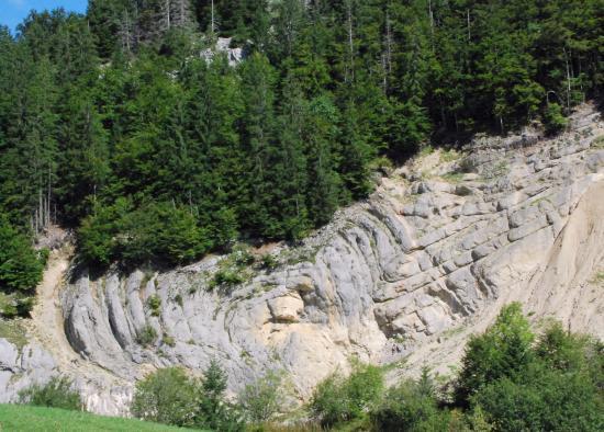
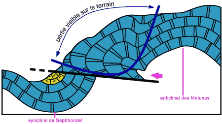
La coupe ci-dessous met en avant l’aspect tectonique du site en nous relatant le caractère disharmonique du pli (zone 2 en jaune).En effet, les couches composées de calcaires marneux ont été plus intensément courbées, donnant la forme de champigon alors que les calcaires plus purs ont été peu déformés. Le fort plissement des couches élastiques s’est produit lorsque le flanc Nord-Ouest de l’anticlinal des Molunes a chevauché le synclinal de septmoncel.
Géomorphologie:
 Lorsque l’on se trouve face au pli constitué de calcaire d’âge oxfordien supérieur (faciès séquanien), on remarque une paroi sur la gauche (zone 1 en rouge). Elle comporte une particularité que vous allez devoir découvrir sur place...
Il s'agit ici de l’œuvre d’une langue glaciaire qui venait se « frotter » contre le le pli en champignon (comme le montre les dépôts morainiques de ce glacier présents en pente tout à droite du plis).
Ainsi, l’action conjuguée du frottement de la glace et des eaux de fonte pendant les périodes estivales se faufilant entre le glacier et la paroi a façonné cette paroi.
De plus, l’action purement mécanique par frottement du glacier est attestée par l’intense striation de la paroi.
Lorsque l’on se trouve face au pli constitué de calcaire d’âge oxfordien supérieur (faciès séquanien), on remarque une paroi sur la gauche (zone 1 en rouge). Elle comporte une particularité que vous allez devoir découvrir sur place...
Il s'agit ici de l’œuvre d’une langue glaciaire qui venait se « frotter » contre le le pli en champignon (comme le montre les dépôts morainiques de ce glacier présents en pente tout à droite du plis).
Ainsi, l’action conjuguée du frottement de la glace et des eaux de fonte pendant les périodes estivales se faufilant entre le glacier et la paroi a façonné cette paroi.
De plus, l’action purement mécanique par frottement du glacier est attestée par l’intense striation de la paroi.
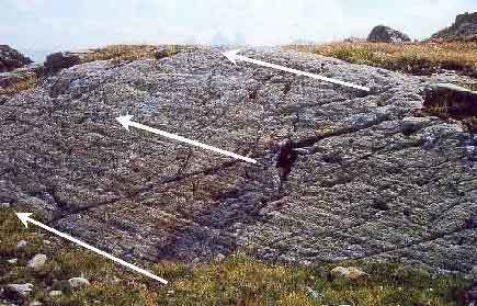 Stries glaciaires (Savoie)
 En effet, ces stries s’expliquent par l’action des blocs rocheux et autres cailloux pris dans la glace qui, au fur et à mesure que le glacier s’écoulait, rayaient la paroi. De près, on constate encore d'ailleurs des cailloux incrustés sur cette dernière...
Le saviez-vous ?
Si vous vous placez devant le pli approximativement aux coordonnées suivantes :
N 46° 20.833 E 5° 53.861
puis demandez à une personne de crier depuis le parking... Vous entendrez alors un bel echo renvoyé par les parois rocheuses du site. J'ai pu constater effectivement le phénomène d'écho par hasard lors de ma visite grâce à des enfants qui jouaient sur le parking... J'avais l'impression qu'ils étaient dans la forêt au dessus du pli en champignon... Et bien non... Le rendu est plutôt bluffant! Alors si vous êtes à plusieurs, n'hésitez pas à tenter l'expérience...
Rappel concernant les « Earthcaches »: Il n'y a pas de conteneur à rechercher ni de logbook à renseigner. Il suffit de lire le descriptif et se rendre sur les lieux afin de répondre au questions posées.
Loguez cette cache "Found it" et envoyez-moi vos propositions de réponses soit via mon profil, soit via la messagerie geocaching.com (Message Center), EN PRECISANT LE NOM ET CODE GC DE LA CACHE et je vous contacterai en cas de problème.
Il est aussi apprécié d'avoir des photos des géocacheurs sur les lieux des EarthCache. Sentez vous inspiré de poster des photos de vous lors de cette visite (optionnelle mais sympa)
QUESTIONS :
1 - Afin de bien faire la différence entre un synclinal et un anticlinal, regroupez les mots de cette liste en 2 groupes bien distincts
convexe - Septmoncel - mont - anticlinal - concave - val - synclinal - Molunes - cuvette - bosse
1er groupe : Septmoncel - ...
2ème groupe : Molunes - ...
2 - Le pli en champignon fait il partie du synclinal de Septmoncel ou de l'anticlinal des Molunes?
3 - Aux coordonnées de la earthcache, sur le panneau, vous trouverez une coupe sensiblement identique à celle du descriptif ci-dessus. Combien de types de calcaire y sont représentés? et quels sont ils?
4 - Toujours sur le panneau, quelle est l'échelle de la carte représentant "le site classé des gorges du flumen" à droite de la description du pli en champignon.
5 - Approchez-vous maintenant de la paroi rocheuse (Zone 1 en rouge).
Carressez sa surface avec votre main, que constatez-vous au touché? Quel élément naturel à l'époque a permis ce phénomène?
6 - De plus près, et pour finir, vous remarquerez aussi les stries sur cette surface (Définition des stries : sillons peu profonds parallèles entre eux qui marquent une surface). Sont elles plutôt horizontales ou verticales? Expliquez pourquoi?
7 - Optionnel mais bien venu, ajoutez à votre log une photo de vous ou votre GPS devant le pli en champignon.
Merci pour l'intérêt que vous avez porté à cette earthcache. Bon géocaching à tous!
The mushroom fold of the Cernaise
The Jura jas many sites presenting us the tectonic style of Jura, one of the best know is that of the Gendarme hat, not far from here...
But there is also the fold in mushroom of the Cernaise, his cousin, that you will discover through this earthcache...
It is a doubly remarkable geosite with geological vocation testifying to the tectonic actions during the establishment of the Haute-Chaîne Jurassienne, but also with local geomorphological vocation witness of the last glaciation. Its easy access by road is an invitation to come to discover it effortlessly ...
Geology :
The section below highlights the tectonic aspect of the site by recounting the disharmonic character of the fold. Indeed, the layers composed of marly limestones were more intensely curved, giving the shape of champigon whereas the purer limestones were little deformed. The strong wrinkling of the elastic layers occurred when the north-west flank of the anticline of Molunes overlapped the syncline of septmoncel.
Géomorphology:
When facing the fold of limestone of upper Oxfordian age (sequanian facies), we notice a wall on the left (zone 1 in red). It has a particularity that you will have to discover on site ...
This is the work of a glacial tongue that was "rubbed" against the mushroom fold (as shown by the morainic deposits of this glacier present on a slope to the right of the folds).
Thus, the combined action of the friction of ice and meltwater during the summer periods slipping between the glacier and the wall has shaped this wall.
Moreover, the purely mechanical action by friction of the glacier is attested by the intense striation of the wall.

Glacial striation (Savoie)
In fact, these streaks are explained by the action of the rock blocks and other pebbles caught in the ice, which, as the glacier flowed, scratched the wall. Close up, you can still see some pebbles encrusted on the latter ...
Did you know ?
If you position yourself in front of the fold at approximately the following coordinates:
N 46 ° 20.833 E 5 ° 53.861
then ask a person to scream from the parking lot ... You will then hear a beautiful echo returned by the rock walls of the site. I could see the phenomenon of echo by chance during my visit thanks to children playing in the parking lot ... I felt they were in the forest above the mushroom fold .. . Well no ... The rendering is rather bluffing! So if you are in a group, do not hesitate to try the experience ...
Reminder concerning the "Earthcaches": There is no container to be searched nor a logbook to be filled in. Just read the description and go to the site to answer the questions asked.

Log in this "Found it" cache and send me your suggestions for answers either via my profile or via the geocaching.com (Message Center) mailing, PRECISING THE NAME AND GC CODE OF THE CACHE and I will contact you in case of problem .

It is also appreciated to have photos of the geocachers on the premises of EarthCache. Feel inspired to post photos of you during this visit (optional but nice)
QUESTIONS :
1 - To make the difference between a syncline and an anticline, group the words of this list into 2 distinct groups
convex - Septmoncel - mont - anticline - concave - val - synclinale - Molunes - basin - bump
1st group: Septmoncel - ...
2nd group: Molunes - ...
2 - Does the mushroom fold form part of the syncline of Septmoncel or the anticline of Molunes?
3 - At the coordinates of the earthcache, on the panel, you will find a section substantially identical to that of the description above. How many types of limestone are represented? and what are they?
4 - Still on the board, what is the scale of the map representing "the classified site of the flumen grooves" to the right of the descent of the fold in mushroom.
5 - Now approach the rock face (Zone 1 in red).
Carry your surface with your hand, what do you notice? What natural element at the time allowed this phenomenon?
6 - Closer, you will also notice the streaks on this surface (Definition of streaks: shallow furrows parallel to each other that mark a surface). Are they rather horizontal or vertical? Explain why?
7 - Optional but come, add to your log a photo of you or your GPS in front of the mushroom fold.
Thank you for your interest in this earthcache. Good geocaching at all!