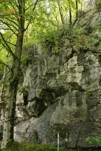
Oberhalb des Alpsees liegt der gut zugängliche Aufschluss im Bunten Liasbasiskalk (Hierlazkalk, Adneter Fazies). Die angewitterten Kalksteine sind meist kompakt und bilden eine markante, tw. von Klueften durchzogene Felswand. Die Wand steht senkrecht und bildet tw. Überhänge. [Bayrisches Geotopenkataster]
Als Kalkstein werden Sedimentgesteine bezeichnet, die ganz überwiegend aus dem chemischen Stoff Calciumcarbonat (CaCO3) in Form der Mineralien Calcit und Aragonit bestehen.
Kalkstein ist ein äußerst variables Gestein; das betrifft sowohl seine Entstehung als auch seine Eigenschaften, das Aussehen und die wirtschaftliche Verwendbarkeit. Es gibt daher innerhalb der Geologie eine eigene Fachrichtung, die Karbonatsedimentologie, die sich ausschließlich mit der Entstehung und den Eigenschaften der verschiedenen Kalksteintypen befasst. Der größte Teil aller Kalksteine ist biogener Entstehung (von Lebewesen abgelagert), es gibt aber auch chemisch ausgefällte und klastische Kalksteine.
Kalksteine besitzen eine enorme wirtschaftliche Bedeutung als Rohstoff für die Bauindustrie und als Naturwerkstein. Des Weiteren sind solche Lagerstätten Speichergestein für Erdöl und Erdgas. [de.wikipedia.org]
Dieser Aufschluss ist im bayrische Geotopkataster unter der Kennummer 777A015 geführt und weist einige Besonderheiten auf:
Im Lias und frühen Dogger wurde durch Dehnungstektonik und große Absenkungen der Ablagerungsraum der Nördlichen Kalkalpen in dem wir uns hier befinden in untermeerische Schwellen und Becken gegliedert. Auf den Schwellen lagerten sich wie hier dünne Kalke ab. Der Bereich der Nördlichen Kalkalpen ist ein typischer Falten- und Überschiebungsgürtel. Als Folge der den Ablagerungen nachfolgenden Faltungen hier die etwa 10 Meter mächtige Felswand um fast 90° aufgerichtet und steht nun fast senkrecht.
Aufgrund der vergleichsweise guten Löslichkeit des Carbonats ist Kalkstein ein durch chemische Verwitterung relativ anfälliges Gestein. An dieser Felswand ist die ursprüngliche Farbe des Kalkgesteins größtenteils grau angewittert an einigen Stellen aber noch erkennbar.
Die massive Wand ist an zahlreichen Stellen durch Kalkspat-Klüfte durchzogen, in denen das Calciumcarbonat. kristalline Struktur gebildet hat.
Um den Cache Loggen zu können beantworte bitte die folgenden Fragen:
1. Welche Höhe erreicht die senkrecht aufragende Wand deiner Schätzung nach?
2. Finde Spuren der ursprünglichen Farbgebung des offensichtlich ausgeblichenen Gesteins.
Welche Farbgebung hatten die Schichten ursprünglich?
3. Beschreibe das Gestein und die dies durchziehenden Kalkspat-Klüfte die du vor Ort vorfindest
(z. B. Zusammensetzung, Beschaffenheit, Farbe, Größe, Anordnung, Besonderheiten, ...)
4. Warum verlaufen so viele der Klüfte horizontal?
Schreibe mir eine eMail mit den Antworten oder kontaktiere mich über das Message-Center.
Es ist nicht notwendig, dass Du auf eine Logfreigabe wartest. Sollte etwas nicht stimmen, melde ich mich und helfe dir bei der Ermittlung der richtigen Antworten.
Ich freue mich sehr, wenn du ein Foto von dir vor Ort im Log hinterlässt.
Ich wünsche euch viel Spaß vor Ort
pico69
Dieses Listing erhält den EarthCache GC319Q2 von nordie69 am Leben, der leider seit Oktober 2017 inaktiv ist und seine ursprüngliche Version archiviert hat.
An EarthCache at the easy accessible outcrop of colorful Liasbaselime.
Above the Alpsees lies an easy accessible outcrop in the colorful Liasbaselime (Hierlazkalk, Adneter Fazies). The weathered limestones are usually compact and form a striking, partially cliff-lined rock face. The wall is vertical and forms partially overhangs. [Translation of Text from Bayrisches Geotopenkataster]
Limestone is a sedimentary rock, composed mainly of skeletal fragments of marine organisms such as coral, forams and molluscs. Its major materials are the minerals calcite and aragonite, which are different crystal forms of calcium carbonate (CaCO3).
About 10% of sedimentary rocks are limestones. The solubility of limestone in water and weak acid solutions leads to karst landscapes, in which water erodes the limestone over thousands to millions of years. Most cave systems are through limestone bedrock.
Limestone has numerous uses: as a building material, an essential component of concrete (Portland cement), as aggregate for the base of roads, as white pigment or filler in products such as toothpaste or paints, as a chemical feedstock for the production of lime, as a soil conditioner, or as a popular decorative addition to rock gardens. [en.wikipedia.org]
This digestion is listed in the Bavarian Geotope Cadastre under the identification number 777A015 and has some special features:
In the Lias and the early Dogger, the stretching space of the Northern Limestone Alps, where we are located here, was subdivided into submarine swells and basins by means of stretching tectonics and great subsidence. Thin skirts were deposited on the sleepers, as here. The Northern Limestone Alps are a typical fold and thrust belt. As a result of the folds following the deposit here the approximately 10 meter thick rock face erected by nearly 90° and is now almost vertical.
Due to the relatively good solubility of the carbonate limestone is a relatively prone to chemical weathering rocks. On this rock face, the original color of the limestone is mostly gray but still recognizable in some places.
The massive wall is pervaded by calcite fissures in numerous places, in which the calcium carbonate has formed crystalline structure.
To log this cache please answer the following questions:
1. What is the elevation of the vertical wall in your estimation?
2. Find traces of the original coloration of the apparently faded rock.
Which color did the layers originally have?
3. Describe the rocks and the calcite fissures that you will find on the site
(e.g. composition, texture, color, size, arrangement, characteristics, ...)
4. Why are so many of the gaps going horizontally?
Write me an email with the answers or contact me via the message center.
It is not necessary that you wait for a log release. If something is wrong, I'll contact you and help you find the right answers.
I am very happy if you leave a photo of you on the spot in the log.
I wish you a lot of fun on site
pico69