Cala Tuent – Volcanes en Mallorca EarthCache
Cala Tuent – Volcanes en Mallorca
-
Difficulty:
-

-
Terrain:
-

Size:  (other)
Please note Use of geocaching.com services is subject to the terms and conditions
in our disclaimer.
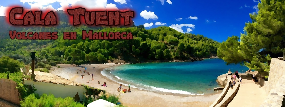


 Cala Tuent
Cala Tuent is a very secluded, quiet bay on the northwestern coast of Majorca. From here you have a magnificent view of the Puig Major and over the surrounding mountains of the Serra de Tramuntana. The bay can be reached by driving Majorca's spectacular 15 km serpentine road MA-2141, which also leads to Sa Calobra and Torrent de Pareis. The road starts at the junction with the MA-10 road (N39° 48.970 E002° 49.452). From here just follow the signs and enjoy the beautiful mountain landscape of the Serra de Tramuntana, which has been declared a World Heritage Site by UNESCO on 27 June 2011.
Like the surrounding Serra de Tramuntana, Puig Major is a limestone mountain and was formed from lime mud, which accumulated in huge quantities on the sea floor in the Jurassic period more than 180 million years ago. About 100 million years ago the African tectonic Plate started moving under the Eurasian Plate, which finally (about 20 million years ago) led to a massive tectonic uplift of the Earth's crust as well as the massive layers of limestone rocks from the bottom of the sea – giving birth to the Balearic Islands with the Serra de Tramuntana as their highest point. At the same time, the Alps, the Pyrenees, the Apennines and the Carpathians were also formed because of this alpine orogeny.
Quite in contrast to the Canary Islands, the Azores or other archipelagos, Majorca is anything but volcanic in origin ... but still you can find volcanic rocks in Majorca, which are much older than the island itself!
Volcanoes on Majorca
Before breaking apart in different tectonic plates, Pangaea was the latest supercontinent in earth's history. It existed as a coherent land mass from about 300 to 150 million years ago and was surrounded by a single giant ocean, Panthalassa. In the middle Keuper, about 220 million years ago, a wide platform towered out of the ocean, where in present-day the Balearic Islands are situated. This region was hot and dry, similar to present-day values in the Red Sea region. Next to the first mammals also volcanoes where very active in this area, leaving their landmarks on Pangaea at this pre-historic time. Liquid magma came to the earth's surface and cooled down rapidly, forming basalt. Basalt is an extrusive igneous rock that is very dark in color. At the same time, gypsum was deposited from the sea water and from volcanic vapors and loamy, reddish-lilac shining sediments were washed up. When the supercontinent Pangaea began to break apart in the middle Keuper 220 million years ago, these earth layers disappeared under the sea's surface to finally show up again, when the tectonic uplift of the Balearic Islands took place - a good 200 million years later.
These geological formations of volcanic and sedimentary rocks, which originated in the Keuper 230 to 200 million years ago, can be found in and around Cala Tuent – and only here!

Logging this Earth Cache
To log this Earth Cache, please e-mail me the answers to the following tasks:
- Describe in your own words, why you can find volcanic rocks can be found in Cala, although the island is not of volcanic origin!
- At the coordinates of the Earth Cache, next to a traditional Majorcan house, you can discover various unveiled earth layers from the Keuper.
- Which specific types of rocks from the middle Keuper can you discover?
- What colors are these different rock types?
- The traditional Majorcan house is surrounded by different stones. Take a closer look at the "stone" in the image, which obviously does not have its origin in the middle Keuper 220 million years ago.
- What type of rock is this?
- And how did you recognize this?
- And after all, and on a voluntary basis: From the position of the Earth Cache, please take a phote of mount Puig Major, by pointing your Camera to 158°.
You can directly start elaborating your log entry and spruce up your profile with the banner, after you sent your answers. If something should by wrong or missing – I am happy to get in touch with you.
Cala Tuent
Esta es la traducción al español hecha por Traductor de Google. Por favor ayuda con la traducción correcta – Estoy muy contento con el apoyo de los GeoCachers españoles.
¡Muchas gracias! 
La Cala Tuent es una bahía muy aislado y tranquilo en la costa noroeste de Mallorca, desde donde se tiene una magnífica vista del Puig Major y las montañas de la Serra de Tramuntana. Se puede llegar a la bahía de manera espectacular sobre la famosa carretera serpentina de Mallorca, MA-2141, que también conduce a Sa Calobra y al Torrent de Pareis. Sólo tiene seguir los signos en el desvío de la MA-10 (N39° 48.970 E002° 49.452) y disfrutar de los siguientes 15 kilómetros, las hermosas montañas de la Serra de Tramuntana. Desde 27 de junio 2011 la Serra de Tramuntana es Patrimonio de la Humanidad por la UNESCO en la categoría de Paisaje Cultural.
La mayor parte de la Serra de Tramuntana se compone de piedra caliza fosilizada, que fue depositada en el período Jurásico hace 180 millones de años en grandes cantidades en el mar. Un poco más de 100 millones de años atrás, la subducción, es decir, el cambio de la placa africana bajo la placa eurasiática, comenzó. Como ocurrió hace unos 20 millones de años, un resultado de este movimiento, con el tiempo a un gran plegamiento de la corteza terrestre, incluyendo las poderosas capas de sedimentación de piedra caliza desde el fondo del mar oriental - el nacimiento de las Islas Baleares había llegado a la Serra de Tramuntana como el punto culminante. Al mismo tiempo, los Alpes, los Pirineos, las montañas del Atlas en el lado de África, los Apeninos y los Cárpatos surgió como un producto de esta orogenia alpina.
En agudo contraste con las Islas Canarias, las Azores u otros archipiélagos, Mallorca no es origen volcánico ... y sin embargo existe. ¡Piedras volcánicas en Mallorca, que son mucho más antiguas que la propia isla!
Volcanes en Mallorca
Pangea era el último supercontinente de la historia de la tierra antes de que las placas continentales individuales comenzaran a separarse. Pangea existió como una masa terrestre cohesiva de hace unos 300 a 150 millones de años y estaba rodeada por un solo mar, el océano gigante de Panthalassa. Donde se encuentra la actual zona de las Islas Baleares, el Keuper medio (hace 220 millones de años) era una plataforma muy amplia del agua. Esta región se puede imaginar como el área actual alrededor del Mar Rojo. Estaba caliente y seco, y además de los primeros mamíferos había volcanes activos aquí, que dejaron su marca en Pangea. En todas partes el magma líquido llegó a la superficie de la tierra, se enfrió. El basalto es una roca volcánica muy oscuro fueron margoso Además en este momento, rojo a los colores púrpura varados sedimentos luminosos y de yeso se deposita a partir de la cual precipitó durante la evaporación de agua de mar. Como entonces, el supercontinente Pangea empezó a resquebrajarse antes de 220 millones años, estos estratos desaparecieron del Keuper Medio bajo la superficie del mar y no llegó hasta los 200 millones de años más tarde revelaron que las Islas Baleares se pliegan como un producto de la orogenia alpina del mar.
¡Es este suelo capas de rocas volcánicas y sedimentarias que han surgido en el Keuper entre 230 y 200 millones de años después de Pangea, se pueden admirar alrededor de la Cala Tuent – y solamente aquí!
Registro de este EarthCache
Para registrar este EarthCache deberéis responder vía correo electrónico a las siguientes preguntas:
- Describa en vuestras propias palabras por qué en el volcán Cala Tuent se encuentra, aunque la isla no es de origen volcánico.
- En las coordenadas de los Caches de la Tierra, se puede descubrir, además de una casa de pueblo tradicional, varias capas de tierra del Keuper, que fueron colocadas allí en una pared.
- ¿Qué tipos de roca de la Keuper media se puede descubrir?
- ¿Qué colores tienen estos diferentes tipos de rocas?
- La casa tradicional está rodeada de piedras, que están apoyadas contra las capas de tierra del Keuper. Echa un vistazo más de cerca a la piedra ("stone") en la imagen, que obviamente no viene de la Keuper medio hace 220 millones de años.
- ¿Qué tipo de roca es esta piedra?
- ¿Y qué reconocías?
- Y después de todo ... y por supuesto, de forma voluntaria, una foto del Puig Major desde el punto de la Cala Tuent es bienvenida. Solamente orientarse con su cámara rumbo 158°.
Podéis hacer el registro y compartir este banner en su perfil después de enviar vuestras respuestas. Si hay algún error ya haré un contacto.
 Cala Tuent
Die Cala Tuent ist eine sehr abgelegene, ruhige Bucht an der Nordwestküste Mallorcas, von der aus man einen herrlichen Blick auf den Puig Major und die umliegenden Berge der Serra de Tramuntana hat. Man erreicht die Bucht spektakulär über Mallorcas berühmte Serpentinenstraße MA-2141, die auch nach Sa Calobra und zum Torrent de Pareis führt. Folgt einfach bei der Abzweigung von der MA-10 (N39° 48.970 E002° 49.452) der Beschilderung und genießt auf den folgenden 15 Kilometern die wunderschöne Berglandschaft der Serra de Tramuntana, die am 27. Juni 2011 von der UNESCO zum Welterbe erklärt wurde.
Der überwiegende Teil des Tramuntana Gebirges besteht aus versteinertem Muschelkalk, der im Jura vor 180 Millionen Jahren in riesigen Mengen im Meer abgelagert wurde. Vor etwas mehr als 100 Millionen Jahren setzte dann die Subduktion, also die Verschiebung der afrikanischen Platte unter die eurasische Platte ein. Als Resultat dieser Bewegung kam es vor rund 20 Millionen Jahren schließlich zu einer gewaltigen Auffaltung der Erdkruste samt den mächtigen Sedimentationsschichten aus Kalkgestein vom Grund des damaligen Meeres – die Geburtsstunde der Balearen war gekommen mit der Serra de Tramuntana als Höhepunkt dieses natürlichen Kreißens. Zur gleichen Zeit entstanden als Produkt dieser alpidischen Orogenese auch die Alpen, die Pyrenäen, das Atlasgebirge auf afrikanischer Seite, der Apennin und die Karpaten.
Ganz im Gegensatz zu den Kanaren, den Azoren oder anderen Archipelen ist Mallorca somit alles andere, als vulkanischen Ursprungs ... und dennoch gibt es sie: Vulkanische Steine auf Mallorca, die wesentlich älter sind, als die Insel selbst!
Vulkane auf Mallorca
Pangäa war der bisher letzte Superkontinent der Erdgeschichte, bevor die einzelnen Kontinentalplatten begannen auseinander zu brechen. Pangäa existierte als zusammenhängende Landmasse etwa von 300 bis 150 Millionen Jahren und wurde von einem einzigen Meer, dem Riesenozean Panthalassa, umgeben. Wo sich das heutige Gebiet der Balearen befindet, ragte im mittleren Keuper (vor etwa 220 Millionen Jahren) eine sehr weitläufige Plattform aus dem Wasser. Diese Region kann man sich wie die heutige Gegend rund um das Rote Meer vorstellen. Sie war heiß und trocken und neben den ersten Säugetieren waren hier zu dieser Zeit auf Pangäa vor allem Vulkane aktiv, die ihre Spuren hinterlassen haben. Überall, wo flüssiges Magma an die Erdoberfläche gelangte, erkaltete es zu. Basalt ist ein sehr dunkles extrusives Eruptivgestein Zusätzlich wurden zu dieser Zeit lehmige, rot- bis lilafarben leuchtende Sedimente angeschwemmt und Gips lagerte sich ab, der bei der Verdampfung des Meerwassers ausgefällt wurde. Als der Superkontinent Pangäa dann vor 220 Millionan Jahren begann, auseinander zu brechen, verschwanden diese Erdschichten aus dem mittleren Keuper unter der Meeresobfläche und kamen erst 200 Millionen Jahre später wieder zutage, als die Balearen als Produkt der alpidischen Orogenese aus dem Meer aufgefaltet wurden.
Eben diese Erdschichten von Vulkan- und Sedimentgestein, die im Keuper vor 230 bis 200 Millionen Jahren auf Pangäa entstanden sind, können rund um die Cala Tuent bewundert werden – und zwar nur hier!
Logeintrag für diesen Earth Cache
Um diesen Earth Cache zu loggen, sende mir bitte die Antworten zu folgenden Aufgaben zu:
- Beschreibe mit deinen eigenen Worten, warum in der Cala Tuent Vulkangestein zu finden ist, obwohl die Insel nicht vulkanischen Ursprungs ist!
- An den Koordinaten des Earth Caches kannst Du neben einem traditionellen Dorfhaus diverse Erdschichten aus dem Keuper entdecken, die dort zu einer Wand aufgestellt wurden.
- Welche Gesteinstypen aus dem mittleren Keuper kannst Du entdecken?
- Welche Farben haben diese unterschiedlichen Gesteinstypen?
- Das traditionelle Dorfhaus ist ringsum mit Steinen eingefaßt, die es gegen die Erdschichten des Keuper abstützen. Sieh Dir den im Bild markierten Stein ("stone") etwas genauer an, der ganz offensichtlich nicht aus dem mittleren Keuper vor 220 Millionen Jahren stammt.
- Um was für einen Gesteinstyp handelt es sich bei diesem Stein?
- Und woran hast Du dieses erkannt?
- Und zu guter Letzt ... und selbstverständlich auf freiwilliger Basis: Mache vom Earth Cache aus ein Foto vom Puig Major, indem Du mit Deiner Kamera einfach in Richtung 158° peilst.
Du kannst sofort mit Deinem Logeintrag beginnen und das Banner in Dein Profil einbinden, nachdem Du mir die Antworten geschickt hast. Wenn etwas falsch ist oder fehlt – melde ich mich gerne bei Dir.
Additional Hints
(No hints available.)