
[FR]
Naurouze

Le seuil de Naurouze est situé à la frontière du département de la Haute-Garonne et du département de l'Aude sur la ligne de partage des eaux entre l’océan Atlantique et la mer Méditerranée; il constitue le point le plus élevé du canal du Midi, qui permet de relier l'Atlantique à la Méditerranée.
Ce seuil est connu depuis l'Antiquité. Strabon, géographe grec, avait appelé ce passage l'isthme gaulois, et la Via Aquitania, voie romaine reliant Narbonne à Toulouse, y passait. Il est la pierre angulaire du projet de construction du canal du Midi de Pierre-Paul Riquet.
C'est en effet le point le plus élevé du parcours (bief de partage), qui nécessite un apport en eau continu pour alimenter le canal. L'ingénieur Riquet a l'idée de récolter les eaux de la Montagne Noire et de les amener jusqu'au seuil. Il fait construire le lac de Saint-Ferréol près de Revel et la rigole qui amène l'eau depuis le lac jusqu'au canal au seuil de Naurouze.
Les deux parties du canal aboutissaient au bassin de Naurouze par deux écluses : l'écluse de l'Océan et l'écluse de la Méditerranée. Quand le bassin fut abandonné, on creusa le bief de partage et les écluses de l’Océan et de la Méditerranée furent reportées plus loin.
Le parcours
On vous propose une petite boucle de cache, de 7 types différents, qui permettent de découvrir ce magnifique site et ses points d’intérêts.
Les caches peuvent être faites dans n'importe quel ordre.
Voici un roadbook que vous pouvez imprimer pour vous aider sur le parcours : Roadbook Naurouze
Bonne promenade et bon géocaching
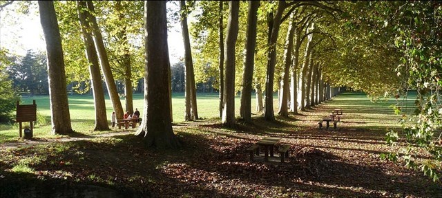
L'allée de platanes
Plantée en 1809, cette très belle allée de platane conduit à l'écluse de l'Océan. Elle est composée de 62 platanes atteignant près de 45 mètres de haut, dont le plus gros mesure 4,17m de circonférence
Elle est l'une des plus belle de France.
De 1974 à 1978, un projet de re-creusement du bassin, à des fins d'irrigation, envisageait de la détruire.

Pour valider cette cache Virtuelle, vous devez ajouter a votre log une photo de l'allée de platanes, en vous cachant derrière un des arbres comme les fortitou, et en ne laissant dépasser qu'une partie de votre corps ( soyez créatifs ! :-) )
Pour en plus bénéficier d'un petit souvenir exclusif, vous devez répondre, par mail ou en message privé via le centre de messagerie, a ces 2 questions :
- Quel était le projet de Riquet concernant l’aménagement du Bassin de Naurouze ?
- Grâce à qui l'allée de platanes fut conservée suite au projet de 1974 ?
Virtual Reward - 2017/2018
This Virtual Cache is part of a limited release of Virtuals created between August 24, 2017 and August 24, 2018. Only 4,000 cache owners were given the opportunity to hide a Virtual Cache. Learn more about Virtual Rewards on the Geocaching Blog.

[EN]
Naurouze
The Naurouze sill is located on the border between the Haute-Garonne department and the Aude department on the watershed between the Atlantic Ocean and the Mediterranean Sea; it constitutes the highest point of the Canal du Midi, which links the Atlantic to the Mediterranean.
This threshold has been known since ancient times. Strabon, a Greek geographer, had called this passage the Gallic isthmus, and the Via Aquitania, the Roman road linking Narbonne to Toulouse, passed through it. It is the cornerstone of Pierre-Paul Riquet's project to build the Canal du Midi.
This is the highest point of the route (sharing reach), which requires a continuous supply of water to feed the canal. The engineer Riquet has the idea of collecting the waters of the Montagne Noire and bringing them to the threshold. He built the lake of Saint-Ferréol near Revel and the gully that brings water from the lake to the canal at the Naurouze sill.
The two parts of the canal reached the Naurouze basin through two locks: the Ocean lock and the Mediterranean lock. When the basin was abandoned, the diversion bay was dug and the locks of the Ocean and the Mediterranean were moved further away.
The route
We propose you a small cache loop, of 7 different types, which allow you to discover this magnificent site and its points of interest.
Caches can be made in any order.
Here is a roadbook that you can print to help you on the way: Roadbook Naurouze
Good walk and good geocaching
The path of plane trees
Planted in 1809, this very beautiful path of plane tree leads to the lock of the Ocean. It is composed of 62 plane trees reaching nearly 45 meters high, the largest of which measures 4.17m in circumference
It is one of the most beautiful path of plane tree in France.
From 1974 to 1978, a project to re-create the basin for irrigation purposes planned to destroy it.
To validate this Virtual cache, you must add to your log a photo of the path of plane trees, hiding behind one of the trees as fortitou, and letting only a part of your body protrude (be creative !. :-) )
To benefit from a small exclusive souvenir , you must answer, by email or in private message through the message center, to these 2 questions:
- What was Riquet's project concerning the development of the Naurouze Basin ?
- Thanks to whom the path of plane trees was preserved following the 1974 project ?
Virtual Reward - 2017/2018
This Virtual Cache is part of a limited release of Virtuals created between August 24, 2017 and August 24, 2018. Only 4,000 cache owners were given the opportunity to hide a Virtual Cache. Learn more about Virtual Rewards on the Geocaching Blog.