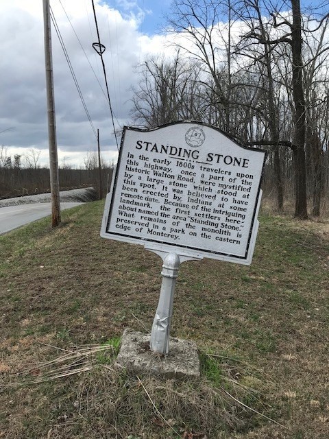
Depending on what you read, the original ""standing stone" resembling the shape of a dog and about 16 feet high and initially west of Monterey, Tennessee, was either a meeting place for the Cherokee and other tribes prior to moving west or a trail marker for the Indians and early settlers.
This stone predates to the infamous "trail of tears" and with the expansion of the railroad, the stone was destroyed, but a large piece was saved, engraved and moved to where it stands today, next to the Monterey Library. The engraving on one face of the stone comes from the Narraganett Tribe #25 – I.O.R.M. (Improved Order of Redmen).
The official dedication was October 17, 1895 and is celebrated every year since 1979 as "Standing stone" day, the second week of every October.
Here's a link to learn more about the "Standing Stone Monument” but won’t help finding the answers to the questions. "http://www.montereytn.com/StandingStone.html”
To log this virtual geocache as a "find", answer these questions after visiting the site and "message" them through the geocache site to me FIRST before logging as a "find". Logs will be deleted if answers are posted in logs or if I don't receive the required "correct" answers which are specific to the site and easily obtained there. Please take your time and check your answers as ALL the answers must be correct to log as a find. Please don't post pictures of yourself with the monument in the picture as pictures will NOT count towards providing visitation proof.
1- How many large stones make up the base of this monument?
2- Between the middle and upper bases, where the 2 marble plaques are mounted, how many stones are in the cylindrical monument?(they're separated by red paint on the grout lines for easy counting)
3-Facing, the stone side with the tomahawk, what is your compass “ numerical degree” reading? "hint" stand where the concrete walkway meets the concrete pad that the monument is on, making sure to face the side where the tomahawk is located and the “direction of travel” compass arrow is pointed directly at the tomahawk. *****The geocaching app will not work for this question. Only an actual compass and some compass apps may work.
4-How many "large" trees surround the monument in the immediate grassy area?
CONGRATULATIONS TO TNnomad ON A FTF!
This Virtual Cache is part of a limited release of Virtuals created between August 24, 2017 and August 24, 2018. Only 4,000 cache owners were given the opportunity to hide a Virtual Cache. Learn more about Virtual Rewards on the Geocaching Blog.