Jökuldalur - a glacial valley
When travelling along the ringroad from Mývatn to Egilsstaðir you pass the valley Jökuldalur which lies between the mountains of Sköldólfsstaðahnjúkur, Háfjall in the north and Hnefill in the south. It streches up to the open area in which finally Egilsstaðir is situated. This valley was formed over ten thousands of years by a glacier and you can still find many remains of the long disappeared glacier while driving through this valley. Not surprisingly a lot of Icelands valleys and mountains were formed by glaciers, but this valley is a good example to learn about how a glacier works and how its remains look like.
Glacier and Glacial erosion
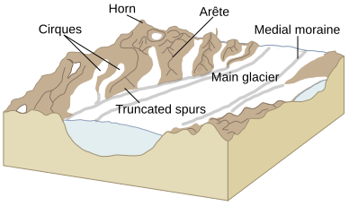
Features of a glacial valley
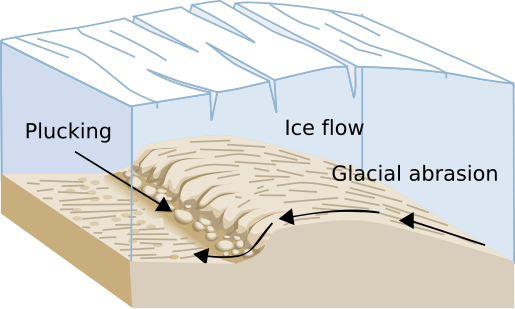
Glaciers still store almost 70% of earth's sweet water and move over periods of time downhill due to gravity and the internal deformation of ice. During this movement it erodes the terrain beneath it by two principal processes: abrasion and plucking.
Plucking
As it flows over bedrock it lifts blocks of rock into the ice and transports it with its overall movement downhill. The plucking is usually caused by subglacial water (which is formed by the high pressure of the glacier itself) that penetrates fractures in the bedrock and subsequently freezes and expands.
Abrasion
When ice and its load of rocks slide over bedrock it functions as sandpaper, smothing and polishing the bedrock below. Abrasion often leads to steeper valley walls.
If a glacier passes bedrock it may cause the rock to be sculpted into a knoll. This is called roche moutonée or sheepback rock. They may range from a few meters to hundred of meters in length.
U-shaped valleys
U-Shaped valleys are formed by glaciation and are characteristic of mountain glaciation. They have a characteristic shape with steep, straight sides and a flat bottom. They are formed when a glacier travels across and down a slope, carving the valley by abrasion. When the ice recedes the valley remains, often littered with small boulders that were transported within the ice. It takes geological tgime spans for a V-shaped valley to be carved in a U-shaped valley.
Glacial till
This is unsorted glacial sediment that can be found all along the glacial valley. Its derived from the erosion and entrainment of material by the moving of ice. It is deposited down the glacial flow to form terminal, lateral, medial and ground moraines.
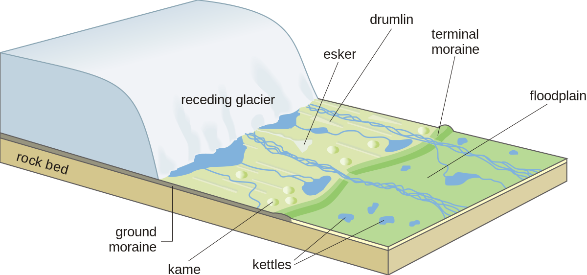
Moraines
Moraines is any glacially formed accumulation of rocks. They can be classified either by origin, location or by shape. There are eight types of moraines, six which form recognisable land forms and two which exist only as long as the glacier exists.
Lateral Moraines
They are parallel ridges of debris deposited along the sides of a glacier. They are formed ny the frost shattering of the valley walls and/or from tribute streams flowing into the valley
Ground Moraines
Ground moraines is till deposited over the valley floor. They are at the base of the ice but also may be deposited as the glacier retreats
Terminal Moraines
Also End Moraines are ridges of rocks and stones deposited at the snout or end of the glacier. They usually reflect the shape of the glacier's terminus. Glacier work like a conveyer belt, carrying debris from the top of the glacier to its very end. Size and shape of end moraines depend on whether the glacier is moving, withdrawing and/or for how long it stayed in one place. Usually terminal moraines grow in size with the time its forming glacier stands in one place.
Medial Moraine
They appear to be a long narrow line or zone of debris which is usually formed when two glaciers join their lateral moraines.
Recessional Moraine
Usually found as a series of ridges running across the valley. They are formed during temporary stops during the glacier's retreat.
At the waypoints you'll see examples of the descriptions above. On the road from wp1 to wp2 you'll probably observe how the valley changes and how broad it becomes when reaching WP2. At WP2 take a look on both sides of the valley and look how steep they are and how the bedrock is smoothed and transformed.
At the listing coordinates you'll find a lot of glacial till on both sides of the road. This is most likely a moraine from the former glacier. Have a closer look on the way the stones are spread over the ground. Which type of moraine is it probably?
When leaving the valley on WP3 you'll enter a great plain which spreads to the ocean. It unites several other valleys which are of a similar appearance like the one you just passed by. Ten thousends of years ago this was all covered by glaciers.
To claim this earthcache
On WP1 N 65° 19.870 W 015° 04.398:
1) How does the valley look like at this waypoint? Describe in your own words what you see and what you think is the reason for this. Did the valley change already when you look back at your drive downhill? Estimate the broadness of the valley at this point and describe its form. When you look on the southside of the valley you'll notice the smoothed bedrock. Is the top of the mountainside at that part of the valley pointy or smoothed? What does this tell you about the height of the glacier?
When you reach GZ at N 65° 21.650 W 014° 52.928 you passed already a lot of other signs of a former glacier in this valley and you see more of these signs at WP2.
2) You are in the middle of a moraine. With regards to the description in the listing - what do you think, what type of moraine is it?
When you reach WP3 at N 65° 25.805 W 014° 36.450 you left the valley already (no need to stop, you may answer this easily just by passing this point).
3) Did you see a terminal moraine? If not, what do you think is the reason for this?
4) Optional: Post a photo of yourself or your GPS at WP1 with the glacial valley in the back.
Send the answers to the questions to me, using my geocaching.com account (link above, username) or the messenger– DO NOT POST them into your log! I’m afraid that I have to delete all logs where no answers are sent.
Icelandic (Unfortunately only a google translation. If anybody could help me to correct this, I'd be very happy!)
Jökuldalur - jökul dalur
Þegar þú ferð meðfram hringveginum frá Mývatni til Egilsstaða ferst þér yfir Jökuldal sem liggur milli Sköldólfsstaðahnjúkar, Háfjalls í norðri og Hnefill í suðri. Það liggur upp á opið svæði þar sem Egilsstaðir eru að lokum staðsett. Þessi dalur var myndaður í tíu þúsundir ára af jökli og þú getur enn fundið margar leifar af löngum horfnum jökli meðan þú keyrir í gegnum dalinn. Ekki kemur á óvart að mikið af dölum og fjöllum Íslendinga myndast af jöklum, en þetta dalur er gott dæmi um að læra um hvernig jökullinn virkar og hvernig það lítur út.
Glacier and Glacial erosion
Lögun af jökul dal </ p> Jöklar geyma enn næstum 70% af söltu vatni jarðarinnar og fara yfir tímabundna tíma niður vegna þyngdarafls og innri aflögunar íss. Á þessari hreyfingu raskar það landslagið undir því með tveimur helstu ferlum: slit og púði.
Plucking
Þegar það rennur yfir bergið lyftir það blokkir bergs í ísinn og flytur það með heildar hreyfingu niður á við. Hreinsunin stafar venjulega af vatni sem er undir jöklinum (sem myndast af miklum þrýstingi jökulsins) sem kemst í brot á botninum og síðan frýs og stækkar.
Slit
Þegar ís og hlaupþrýstingur þess rennur yfir bergstein, virkar hún sem sandpappír, sleikir og fægir botninn að neðan. Slípun leiðir oft til steypu veggjum í dalnum.
Ef jökull fer yfir berggrunn getur það leitt til þess að kletturinn sé myndaður í knoll. Þetta heitir roche moutonée eða sheepback rokk. Þeir geta verið á bilinu nokkurra metra til hundruð metra að lengd.
U-laga dölur
U-lagðar dölur myndast af jökli og eru einkennandi fyrir fjallglaciation. Þeir eru með einkennandi lögun með brattum, beinum hliðum og flatt botni. Þeir myndast þegar jökull fer yfir og niður brekkuna og útskorið dalinn með því að slíta. Þegar ísinn dregur úr, er dalurinn ennþá fullur af litlum bjöllum sem voru fluttar í ísinn. Það tekur jarðfræðilegar tgime spannar fyrir V-laga dalnum að vera skorið í U-laga dalnum.
Glacial til
Þetta er óflokkað jökul seti sem er að finna allan jökulinn. Það er afleiðing af rof og meðhöndlun efnis með því að flytja ís. Það er sett niður í jökulflæði til að mynda flugstöðvar, hliðar-, miðgildi og jörðarmörk.
Moraines
Moraines er einhver glacially myndast uppsöfnun steina. Þau geta verið flokkuð annaðhvort með uppruna, staðsetningu eða lögun. Það eru átta tegundir moraines, sex sem mynda þekkta landform og tveir sem aðeins eru til staðar svo lengi sem jökullinn er til.
Lateral Moraines
Þeir eru samhliða hryggir af rusl sem eru afhent meðfram jökulhliðum. Þau eru mynduð ný frostbrot í dalveggjum og / eða frá hryggjunni sem flæðir inn í dalinn.
Ground Moraines
Ground moraines er þar til afhent yfir dalinn. Þau eru á botni íssins en einnig má afhenda sem jökulhæðin
Terminal Moraines
Enda Moraines eru hryggir af steinum og steinum sem eru settar í snjó eða enda jökulsins. Þeir endurspegla venjulega lögun járnbrautarstöðva. Jökull vinnur eins og færibandið og færir rusl frá jökulhæðinni til enda. Stærð og lögun endurnýjunarefna fer eftir því hvort jökullinn hreyfist, dregur úr og / eða hversu lengi hann var á einum stað. Venjulega verða járnbrautir í stærð við þann tíma sem myndast jökull stendur á einum stað. </ P>
Medial Moraine
Þeir virðast vera langur þröngur lína eða svæði af rusli sem venjulega myndast þegar tveir jöklar ganga í hliðarhæð þeirra.
Recessional Moraine
Venjulega að finna sem röð af hryggjum sem liggja yfir dalinn. Þau eru mynduð á tímabundnum hættum á undanförnum jöklum.
Á leiðarljóðum sjáum við dæmi um lýsingar hér að ofan. Á veginum frá wp1 til wp2 muntu líklega fylgjast með því hvernig dalurinn breytist og hversu breiður það verður þegar hann nær WP2. Á WP2 kíkja á báðum hliðum dalarinnar og líta á hversu bratt þau eru og hvernig berggrunnurinn er sléttur og umbreyttur.
Á skráningshnitunum finnur þú mikið af jöklum þar á báðum hliðum vegsins. Þetta er líklega morese frá fyrrum jökli. Kíktu á hvernig steinarnir dreifast yfir jörðu. Hvaða tegund af moraine er það líklega? Þegar þú ferð úr dalnum á WP3 kemst þú inn í stórt lát sem breiðist út í hafið. Það sameinar nokkrar aðrar dölur sem eru af svipuðum útliti eins og sá sem þú fórst bara framhjá. Tíu þúsundir ára síðan var þetta allt undir jöklum.
Til að krefjast þessa jarðskjálfta
Á WP1 N 65 ° 19.870 W 015 ° 04.398
1) Hvernig lítur dalurinn út á þessu leiðarpunkti? Lýstu í eigin orðum hvað þú sérð og hvað þér finnst er ástæðan fyrir þessu. Breyttu dalurinn þegar þú horfir aftur á akstursfjarlægðinni þinni? Meta breidd dalarinnar á þessum tímapunkti og lýsið formi hans. Þegar þú horfir á suðurhlið dalarinnar munt þú taka eftir því að sléttur berggrunnur. Er efst á fjallinu í þessum hluta dalarinnar punktur eða sléttur? Hvað segir þetta um hæð jökulsins?
Þegar þú nærð GZ á N 65 ° 21.650 W 014 ° 52.928 fórst þú nú þegar mikið af öðrum táknum fyrrverandi jökuls í þessum dal og þú sérð fleiri af þessum skilti á WP2.
2) Þú ert í miðri morene. Með tilliti til lýsingarinnar í skráningunni - hvað finnst þér, hvaða tegund morese er það?
Þegar þú nærð WP3 á N 65 ° 25.805 W 014 ° 36.450 þú fórst frá dalnum þegar (þú þarft ekki að hætta, þú getur svarað þessu auðveldlega bara með því að fara með þetta punkt).
3) Varð þú að sjá Terminal Moraine? Ef ekki, hvað finnst þér ástæðan fyrir þessu?
4) Valfrjálst: Settu inn mynd af sjálfum þér eða GPS þínum á WP1 með jökuldalnum í bakinu.
Sendu svörin við spurningunum til mín, með því að nota geocaching.com reikninginn minn (tengilinn hér fyrir ofan, notendanafn) eða sendiboðarinn-Ekki skrifaðu þær í þig! Ég er hræddur um að ég þarf að eyða öllum logs þar sem engin svör eru send.
Sources:
I used mainly wikipedia and http://www.geography-site.co.uk/ as a source to create this earthcache