About Village Sign Caches
|
 ⠀ ⠀ |
This cache belongs to the Village Sign Series, a series of caches based on ornate signs that depict the heritage, history and culture of the villages that put them up (generally on the village green!).
The signs can be made of different materials from fibreglass to wood, from forged steel to stone. They can depict anything from local industry to historical events. The tradition probably started in Norfolk or Suffolk and has now spread across most of the country so we thought we would base a series on them!
|
More information, bookmarks and statistics can be found at the Village Signs Website
If anybody would like to expand the Village Sign Series, please do.
I would ask that you request a number for your cache first at www.villagesignseries.co.uk
so we can keep track of the Village Sign numbers and names to avoid duplication.
The following information about this lovely Sussex village comes from the excellent Wikipedia:
The name Balcombe may mean "Mining Place Camp". Bal is a Cornish word meaning a mining place as in Bal Maidens, and the same word may have existed in Ancient British Celtic. Although Coombe or Combe can mean a valley, it can also come from the Roman "camp". So possibly from its name Balcombe could have once been a Romano-British mining settlement.
South of Balcombe on the London to Brighton railway line is the Ouse Valley Viaduct. Designed and engineered by John Urpeth Rastrick (1780–1856) in consultation with the talented architect David Mocatta, it was completed in 1842. It is 100 feet (30 m) high and 500 yards long. It has 37 arches and was built with 11 million imported Dutch bricks.
Balcombe sits in the middle of some lovely English countryside and is renowned far afield for the myriad hides of the distinguished cacher Flatcoat Walker(aka FCW) who lives not far away. The village is literally surrounded by her caches, set out in several well-maintained series, more than one of which dates back to 2008. In fact, her #1 Balcombe Boundaries is almost the nearest cache to this one. The nearest is probably our Fine Pair cache GC3Q3FK
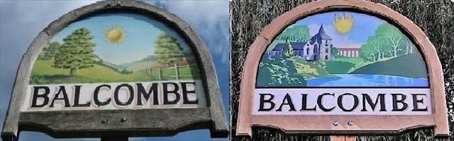
A year or more ago, we had the intention of doing our first Village Sign cache here but when the moment came to look at it seriously, the sign had - shock, horror - been removed! Passing through recently, Mr AnT saw that a brand new sign has been erected! What better moment to publish a new cache?
Here are what the old and the new signs look like up close:
![]()
What are the differences?
The new sign contains the additional images of the Ouse Valley Viaduct and the village church, St. Mary’s (see also sadexploration’s Church Micro 2001...Balcombe GC305WZ for a bit of its history.
At, or very near, the published co-ordinates you will find – nailed onto a pole – a small, partly rusted metal plate with partially serrated top and bottom edges. The plate also has 6 digits punched into it. Let’s call the first 2 digits, which are on the upper line, A and B. On the lower line are 4 digits we will call C D E and F. Due to these digits being a little unclear for the visually challenged, a cross-check is that the sum of the digits in the top line is 9 and the sum of the bottom line is 21.
Substitute the numbers represented here by the above letters in the following data set which will then be the co-ordinates you need to find the cache, but with a small correction applicable from 26/03/2022 due to the cache container having gone missing as the natural camo at its original location was removed.
So, having worked out a set of co-ordinates with the original formula:
N 51° 03.A(B+C)E W 000° 08.C(B-D)(A-C) add 0.010 onto the Westing. Easy peasy
The container is a 110 ml screw-top pot, double-boxed. Unfortunately, due to the proximity of other caches and a scout hut, we have had to give you a bit of a walk to the actual cache location. But not too far. Hope you enjoy it!
About Village Sign Caches
|
| ⠀ |
This cache belongs to the Village Sign Series, a series of caches based on ornate signs that depict the heritage, history and culture of the villages that put them up (generally on the village green!).
The signs can be made of different materials from fibreglass to wood, from forged steel to stone. They can depict anything from local industry to historical events. The tradition probably started in Norfolk or Suffolk and has now spread across most of the country so we thought we would base a series on them!
|
More information, bookmarks and statistics can be found at the Village Signs Website
If anybody would like to expand the Village Sign Series, please do.
I would ask that you request a number for your cache first at www.villagesignseries.co.uk
so we can keep track of the Village Sign numbers and names to avoid duplication.