[PL]
Czerwony granit
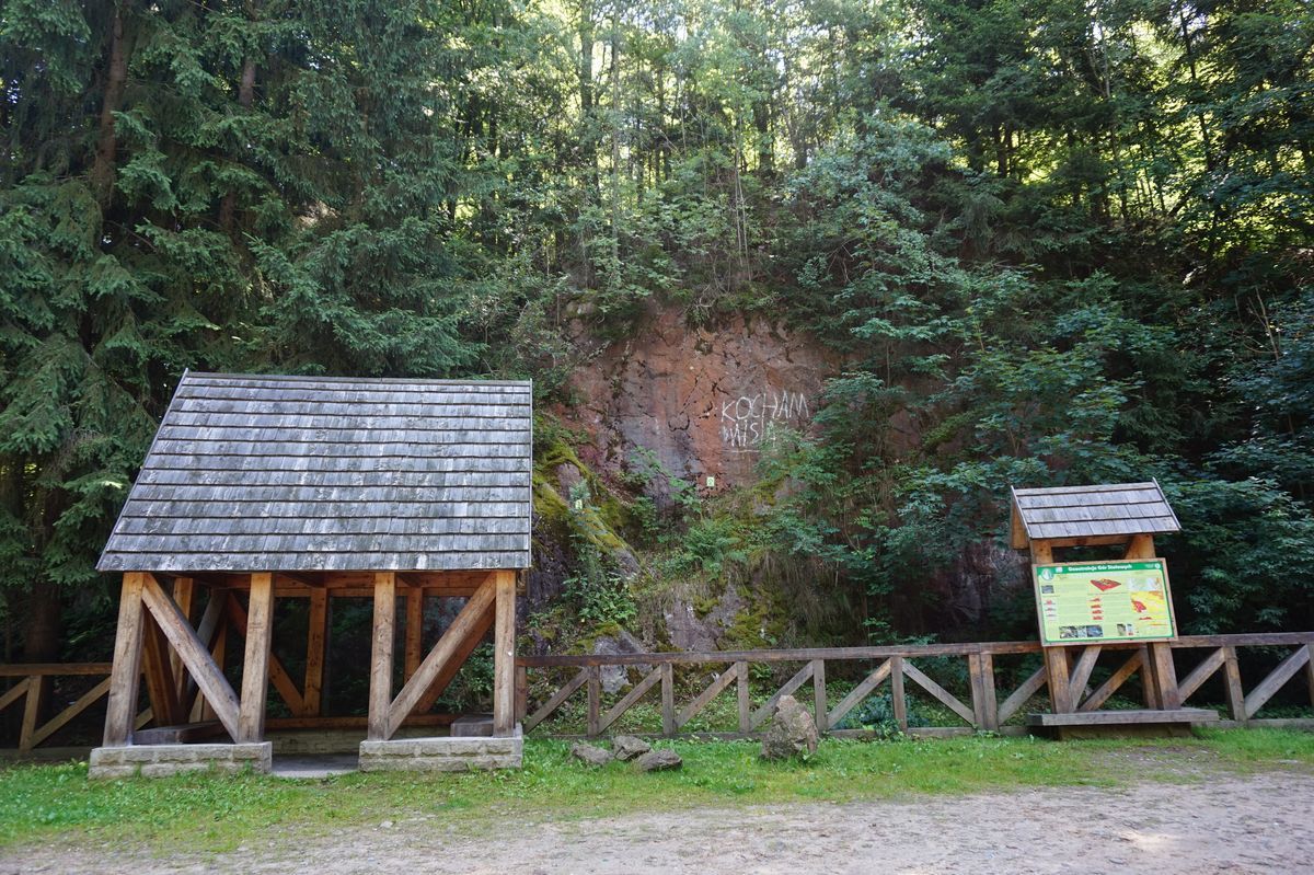
Czerwona skała tu występująca jest granitem, czyli skałą magmową, składającą się z kwarcu, skalenia i minerałów barwnych - tutaj ciemnego biotytu. Swoją barwę zawdzięcza dużym, czerwonym kryształom skalenia tzw. fenokryształom, które powstały w magmie jako pierwsze (dobrze wykształcone widoczne są gołym okiem). Nie jest to jedyna skała magmowa w tym rejonie Gór Stołowych - spotkamy tu granodioryty, tonality i kataklazyty, które wraz ze skałami metamorficznymi tworzą tzw. masyw Kudowy.
Skąd tutaj granit?
Magma granitowa płynąca z wnętrza ziemi intrudowała w skały masywu znanego pod nazwą jednostka Orlicy, a która uchodzi za jedną z najstarszych skał w Sudetach powstałych w paleozoiku - w ordowiku i sylurze. Wtryśnięcie lawy odbywało się naturalnymi kanałami poprzez spękania, uskoki i szczeliny - miejsca, gdzie istniała pustka w skale, a którędy magma mogła wniknąć. Jednym z takich szczególnych miejsc jest uskok Porici-Hronov - jeden z najważniejszych dla powstania Sudetów.
Granit ten już po powstaniu był wielokrotnie deformowany i niszczony w czasie kolejnych epok geologicznych. W wyniku tego powstały spękania i uskoki, w które wnikała z kolei gorąca woda magmowa zawierająca rozpuszczone w niej różne minerały. I tak z wody tej wytrącały się np. związki żelaza, uranu i inne.
Geneza Czerwonej Skały
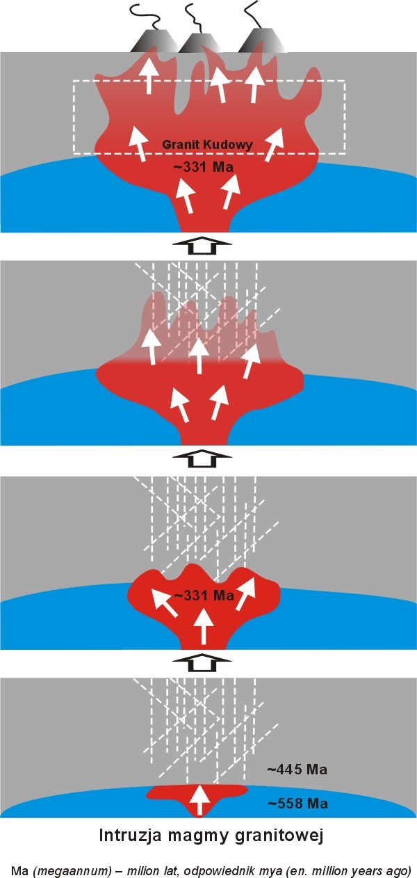
Pod koniec ery paleozoicznej w westfalu (górny karbon), gdy w wyniku orogenezy warycyjskiej doszło do wypiętrzenia granitu Kudowy, znalazł się on na powierzchni. Tu uległ wietrzeniu chemicznemu i przekształcił się w saprolity (czyli zwietrzelinę).
W permie nastąpiła erozja saprolitów i osadzały się on w nieckach w postaci czerwonego spągowca. Nastąpiło erozyjne zrównanie terenu nazywane pedyplenizacją.
W kredzie obszar Sudetów zalało morze i w wyniku działania fal morskich doszło do wypłukania zwietrzelin, które osadziły się w morzu w postaci piasków i mułów, które dały początek powstaniu skał osadowych tworzących obecnie Góry Stołowe.
W trzeciorzędzie, gdy Sudety stały się górami, znów obserwujemy erozję wszystkich skał i wymywanie ich przez wodę.
Struktura geologiczna
Czerwona Skała pozwala nam zaobserwować pewne deformacje tektoniczne obszaru Kudowy, charakterystyczne dla strefy uskokowej Porici-Hronov.
Na spękaniach możemy dostrzec lustra tektoniczne z rysami i zadziorami, które są śladami po przesuwaniu się mas skalnych, pokazując kierunek ich przemieszczania się względem siebie.
Możemy też zaobserwować tu struktury pierzaste, które powstają gdy skała pęka w wyniku rozciągania. Znajdziemy tu także tzw. kieszeń, gdzie zbierał się silnie zwietrzały granit jako tzw. grus. Jest on produktem erozji skały w warunkach ciepłych i wilgotnych - czyli w westfalu.
Grus jest częścią saprolitu - zwietrzeliny o charakterystycznym ułożeniu skał - od ziarnistej z mniej lub ostrokrawędziowymi bloczkami po drobnoziarnisty, gliniasty materiał o dużej ilości kaolinu.
Zadania:
- Rysy tektoniczne - znajdziesz je po lewej stronie na wystającym kawałku skały. Oceń w jakim kierunku są skierowane - czyli w jakim kierunku przesuwały się skały względem siebie?
- Na skale znajdziesz cyfry, będące częścią stałej instalacji - co symbolizuje cyfra 3, a co 2?
- Saprolit - w wyniku jakich procesów powstał i w którym miejscu odkrywki jest widoczny?
- Jakie procesy sprawiły, że w skałach w okolicy Kudowy pojawiły się rudy uranu i żelaza?
- Podaj swoją wysokość n.p.m.
- Nieobowiązkowo - zdjęcie swoje w tym miejscu lub twojego GPS.
[EN]
Red granite
The red rock that appears here is a granite, a kind of a magma rock, consisting of quartz, feldspar and color minerals - here a dark biotite. It owes its color to a large, red crystals of feldspar so-called phenocrystals, which were created in magma as a first crystals (well-developed are visible to the naked eye). This is not the only igneous rock in this region of the Table Mountains - here we can see granodorytes, tonalities and cataclysses, which together with metamorphic rocks form the Kudowa massif.
Where does granite come from?
Magma granite flowing from the interior of the earth intruded into the rocks of the massif known as the Orlica unit, which is considered one of the oldest rocks in the Sudety mountains formed in the Paleozoic - Ordovician and Silurian. The injection of lava took place through natural channels through cracks, faults and fissures - a place where there was a void in the rock, and which way magma could penetrate. One of such special places is Porici-Hronov fault - one of the most important for the creation of the Sudetes.
This granite, after the uprising, was repeatedly deformed and destroyed during subsequent geological eras. As a result, cracks and faults were formed, in which hot magma water contained various minerals dissolved in it. And so, for example, compounds of iron, uranium and others precipitated from this water.
Genesis of the Red Rock
At the end of the Paleozoic era in the Westphalian (Upper Carboniferous), when the Kudowa granite was stirred up as a result of conditional orogenesis, it found itself on the surface. Here, it has undergone chemical weathering and has transformed into saproliths (meaning sort of a dust).
In the Permian the saprolites eroded and settled in the basin in the form of a rotliegend. There has been an erosive equation of the area called pedyplenization.
In the Cret, the area of the Sudety mountains was flooded by the sea and as a result of the action of sea waves there was a washing out of the weathered air that settled in the sea in the form of sands and mules, which gave rise to the formation of sedimentary rocks currently forming the Table Mountains.
In the Tertiary, when the Sudetes became mountains, we again observe erosion of all rocks and washing them out through water.
Geological structure
The Red Rock allows us to observe some tectonic deformations of the Kudowa area, characteristic of the Porici-Hronov fault zone.
On the cracks we can see tectonic mirrors with scratches and burrs, which are traces of the rock masses moving, showing the direction of their movement relative to each other.
We can also observe here pinnate structures, which arise when the rock breaks as a result of stretching. We can also find here the so-called pocket, where heavily weathered granite was collected as so-called grus. It is a product of rock erosion in warm and humid conditions - means in Westphalian.
Grus is a part of saprolite - a decay with a characteristic rock arrangement - from grainy with less or sharp edges to fine-grained, loamy material with a lot of kaolin.
Tasks:
- Tectonic scratches - you will find them on the left side on a protruding piece of rock. Assess in which direction they are directed - in which direction did the rocks move in relation to each other?
- On the rock you will find digits, which are part of a permanent installation - what is the number 3 and what about 2?
- Saprolite - as a result of which process was created and in which place the opencast is visible?
- What processes caused uranium and iron ores to appear in the rocks near Kudowa?
- Enter your altitude n.p.m.
- Optionally - picture yours here or your GPS.
[PL]
Skrzynka typu EarthCache, nie posiada fizycznego pojemnika. Aby zalogować znalezienie tego EarthCache, musisz udać się pod wskazane współrzędne, odpowiedzieć na powyższe pytania. Odpowiedzi proszę wysyłać za pomocą mojego profilu. Nie trzeba czekać na moją odpowiedź, można od razu logować. Jeśli coś będzie nie tak, zgłoszę się sam. W razie potrzeby pomogę w rozwiązaniu zadań. Logi bez podesłanych odpowiedzi będą kasowane.
[EN]
EarthCache not have a physical container. To log in finding EarthCache, you must go to the provided coordinates and answer these questions. Please send answers via my profile. No need to wait for my answer, you can immediately log. If something is wrong, I will send you a message. If you need help in solving tasks just ask me. Logs without answers will be deleted.
Bibliografia / Bibliography:
- Wojewoda J., Geoatrakcje Gór Stołowych - przewodnik geologiczny po Parku Narodowym Gór Stołowych. Park Narodowy Gór Stołowych, 2011
- Janeczek J., Kozłowski K., Żaba J. Zbieramy minerały i skały. Wydawnictwa Geologiczne, Warszawa 1991