नेपाली, nepālī;
को स्मृति मा: Jerzy Kukuczka
Google संग अनुवाद:
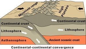
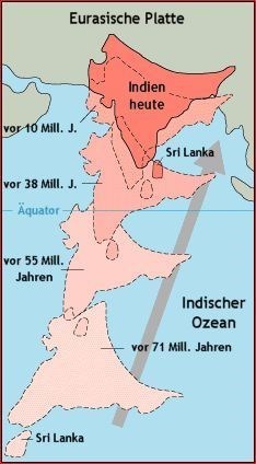
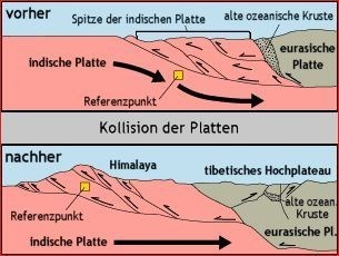
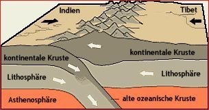
भारतीय एशिया मा एशियाली ल्याण्डमास मा वर्ष लाखौं सार्दा छ। यो प्रति वर्ष तीन सेन्टिमिटर संग उत्प्रेरित गर्छ। एक पटक दुवै महादेशमा एक समुद्र द्वारा विभाजित थिए। कारण समुद्र को जबरदस्त टकराव गर्न गायब। सागर तल माथिको धक्का र हिमालय भयो।
चट्टान (metamorphosis) बदल दुवै को कन्टिनेन्टल प्लेट को लागि उच्च दबाव र चरम गर्मी अन्तर्गत। सगरमाथा (बारेमा 5400 मीटर) को सबै भन्दा कम भाग हदसम्म गाढा रक हुन्छन्।
थप पहाड माथि, तपाईं विशाल उज्ज्वल ग्रेनाइट ब्लक पाउनुहुनेछ। 7500 मिटर भन्दा बढि मा एक पटक Tethys महासागर को तल थिए उच्च चट्टानहरु छन्। समुद्री जनावर यी रहलपहल सानो रूपान्तरण गर्न विषय थिए र यसरी बलुआ र चूना परिवर्तन गरेका थिए। यी तहहरू पहेंलो रंग छ। यसैले नाम "पहेंलो रिबन"। पर्वतमा (शिविर III र शिविर चतुर्थ बीच) को दक्षिण पश्चिम पक्षमा र (लगभग 8000 मिटरसम्मको) उत्तरका पक्षमा दुवै तपाईं चट्टानको यस प्रकारको पाउनुहुनेछ।
सगरमाथा को शिखर शुद्ध चूना बनेको छ। रंग खैरो छ। हिमालहरूको गठन सागर तल केहि सय मिलियन वर्ष मा, माथि सगरमाथा को शिखर गर्न सबै बाटो ओसारपसार छ। भूवैज्ञानिक मात्रा अवलोकन, यो प्रक्रिया धेरै छोटो समयमा भयो र अझै पनि चलिरहेको छ। प्रत्येक वर्ष पहाड केही मिलिमिटरमा लिफ्टहरु। यसलाई साथ क्षरण संग थप सुधार को अन्तरक्रिया लागि नौ हजार सगरमाथा हुन सक्छ कि देखेको गर्न रहनेछ।
क्यास लग, यी प्रश्नबारे हुनुपर्छ:
1. समन्वयमा विभिन्न आकारका पत्थर र चट्टानहरू छन् जुन चट्टानहरू तिनीहरूका हुन्?
2. क्या तपाईं ग्रेनाइट र gneiss को बीच अंतर को व्याख्या गर्न सक्छन्?
3. यदि तपाईं गोरक शेपबाट बेस क्याम्पमा जानुहुन्छ भने तपाईलाई खुम्बु ग्लेशियरमा जानुपर्छ?
4. साइट (वैकल्पिक) मा छवि गर्नुहोस्।
हामीलाई ई-मेल गरेर जवाफ पठाउन। त्यसपछि तपाईं लग गर्न सक्नुहुन्छ। केही गलत हो भने, हामी तपाईंलाई सम्पर्क गर्नेछौं।
Der indische Subkontinent driftet nach Norden
Subkontynent indyjski dryfuje na północ
The Indian subcontinent drifts north
Der Himalaya entsteht über der Subduktionszone
Himalaje powstają ponad strefą subdukcji
The Himalaya emerges above the subduction zone
Plattentektonik des Himalayas
Tektonika płyt Himalajów
Plate tectonics of the Himalayas

Deutsch:
In Erinnerung an meinen schlesischen Landsmann: Jerzy Kukuczka.
Der indische Subkontinent prallt bereits seit 50 Millionen Jahren gegen die asiatische Landmasse auf. Dieser bewegt sich mit ca. drei Zentimetern pro Jahr nach Norden. Einst waren beide Kontinente durch den Ur-Ozean namens Tethys getrennt. Durch den gewaltigen Zusammenstoß verschwand der Ozean. Der Ozeanboden schob sich nach oben und wurde in ein komplexes Faltengebirgssystem gezwungen, den Himalaya.
Unter dem gewaltigen Druck und der extremen Hitze dieses andauernden Zusammenstoßes beider Kontinentalplatten veränderte sich das Gestein (Metamorphose). Im gesamten Everest-Massiv besteht der unterste Teil der Gipfelpyramide ab 5400 Meter (die Höhe vom Base Camp) zum großen Teil aus metamorphem Gestein, vor allem dunklen, Gneisen und grobkörnigem Schiefergestein. Dieses wurde aus dem glühenden Erdmantel in die Basis des Massivs gepresst.
Weiter oben am Berg, also im unteren Teil der großen Wände des Everest, findet man riesige hell gefärbte Granitblöcke. In über 7500 Metern Höhe liegen Sedimentgesteine, die sich einst am Grund des Tethys-Ozeans befanden. Diese Tone, Schlicke und Kalkreste von Meerestieren unterlagen nur in geringem Maße der Metamorphose und wurden somit in Sandstein, Kalkstein und Schiefer umgewandelt. Beweis für diese Prozesse sind noch heute die Korallenfunde hoch oben im Himalaya. Diese Schichten haben eine helle gelbliche Grundfärbung. Daher auch die Bezeichnung „Gelbes Band“. Sowohl auf der Südwestseite des Berges (zwischen Lager III und Lager IV) als auch auf der Nordseite (auf ca. 8000 Meter gelegen) findet man diese markante Gesteinsformation.
Der Gipfelbereich des Mounts Everest besteht aus reinem Kalkstein. Die Grundfarbe ist grau mit sandigen Einlagerungen. Die Gebirgsbildung hat die Sedimente vom Grund des Ozeans in wenigen hundert Millionen Jahren ganz nach oben auf den Gipfel des Everest transportiert. In geologischen Maßstäben betrachtend hatte sich dieser Prozess in sehr kurzer Zeit abgespielt und er ist noch in vollem Gange. Jedes Jahr hebt sich der gesamte Gebirgsstock um einige Millimeter. Bleibt über die nächsten Jahrmillionen abzuwarten, ob und wann das Zusammenspiel aus weiterer Hebung bei gleichzeitiger Erosion den Everest zum Neuntausender werden lässt.
Um den Cache zu loggen müssen folgende Fragen beantwortet werden:
1. An den Koordinaten liegen Steine und Felsen in verschiedenen Grössen, aus welchen Gestein sind sie?
2. Kannst du mir den Unterschied zwischen Granit und Gneis erläutern?
3. Wenn man vom Gorak Shep zum Base Camp geht, muss man über den Khumbu Gletscher gehen?
4. Mache bitte ein Bild im Base Camp.
Sende die Antworten an uns. Du kannst dann direkt loggen. Wenn was nicht stimmen sollte, melden wir uns.
ACHTUNG: Logs, die nicht den Anforderungen entsprechen, werden kommentarlos gelöscht! Der Cache wurde am 07 November 2017 veröffentlicht. Ich akzeptiere keine Loggs die man vor dem Datum einfügt. Vor dem 07 November 2017 gabt es dort keinen Cache. Basta !!!

Polski:
Ku pamięci mojego śląskiego rodaka: Jerzy Kukuczka.
Subkontynent indyjski porusza się już od 50 milionów lat w kierunku azjatyckiego lądu i to około trzech centymetrów rocznie na północ. Obydwie płyty kontynentalne były oddzielone pierwotnie oceanem o nazwie: Tetyda. Ze względu na ogromną ilość kolizji ocean zniknoł. Dno oceanu przysunęło się do gόry, co doprowadziło do powstania Himalajów.
Pod wpływem dużego ciśnienia i wysikich temperatur w trakcie ciągłych kolizji tych obydwu płyt kontynentalnych powstały tu skały metamorficzne. Powyżej 5400 metrόw (wysokość bazy głόwnej) piramida masywu Everestu składa się głównie z skał metamorficznych, szczególnie z ciemnego gnejsu oraz gruboziarnistego łupku.
Wyżej w górze na wielkich ścianach Everestu znajdują się ogromne granitowe bloki o jasnych kolorach. Na wysokości ponad 7500 metrów znajdują się skały osadowe, które kiedyś były na dnie oceanu Tetydy. Te gliny, muły i wapienne resztki zwierząt morskich zostały poddane metamorfozie i zostały w ten sposób przekształcone w piaskowiec, wapień i łupki. Dowodem tych procesów są znaleziska koralowcόw wysoko w Himalajach. Warstwy te mają jasne żółte zabarwienie, stąd ich nazwa „żółta wstęga”. Zarówno od strony południowo-zachodniej części góry (pomiędzy obozen III i obozem IV), jak również na stronie północnej znajduje się taka formacja skalna.
Sam szczyt Mount Everestu składa się z czystego wapienia o szarym kolorze . W trakcie orogenezy Himalajόw osady z dna oceanu zostały przetransportowane w ciągu kilkuset milionów lat aż na sam szczyt Everestu. W skali standardów geologicznych proces ten odbył się w bardzo krótkim czasie i wciąż się odbywa. Każdego roku, cały masyw wznosi się o kilka milimetrów. W ciągu najbliższych milionόw lat okaże się czy Everest osiągnie wysokość dziewięciu tysięcy metrόw przy rόwnoczesnej erozji tej gόry.
Aby zalogować ten cache należy odpowiedzieć na następujące pytania:
1. Na współrzędnych leżą kamienie i skały o różnych rozmiarach, z jakiego minerału są one?
2. Czy możesz mi wytłumaczyć różnicę między granitem i gnejsem?
3. Jak idziesz z Gorak Shep do Base Camp, czy musisz przejść przez lodowiec Khumbu?
4. Proszę zrób zdjęcie w bazie głόwnej.
Zalogować "znalezienie" możesz bezpośrednio po przesłaniu odpowiedzi przez mój profil. Jeżeli Twoje odpowiedzi będą błędne, zgłoszę się sam.
UWAGA: Wpisy niespełniające wymagań zostaną usunięte bez komentarza! Skrytka (cache) została opublikowana 7 listopada 2017 r. Nie akceptuję logów-wpisów przed tą datą. Nie było tam żadnej Geo-skrytki przed 7 listopada 2017 roku. Basta !!!

English:
In memory of my Silesian countryman: Jerzy Kukuczka
The Indian subcontinent has been bouncing on the Asian landmass for 50 million years. This moves to the north at about three centimeters per year. Once, both continents were separated by the primeval ocean called Tethys. The ocean disappeared as a result of the huge clash. The ocean floor pushed upwards and was forced into a complex folding system, the Himalayas.
Under the enormous pressure and the extreme heat of this continual clash of both continental plates, the rock (metamorphosis) changed. In the entire Everest massif, the lowest unit of the summit pyramids above 5400 meters (The height of Base Camp) consists mainly of metamorphic rock, mainly dark, gneiss and coarse-grained slate rocks. This was pressed from the glowing mantle of the earth into the base of the massif.
Further up the mountain, in the lower part of the huge walls of the Everest, you will find huge brightly colored granite blocks. At an altitude of more than 7500 meters, sedimentary rocks are located, which once stood at the bottom of the Tethys Ocean. These clays, smears, and limestone deposits of marine animals were only slightly transformed into metamorphosis and were thus converted into sandstone, limestone, and slate. Evidence for these processes is still today the coral reefs high up in the Himalayas. These layers have a light yellowish coloration. Therefore their name is "The Yellow Band". Both on the south-west side of the mountain (between camp III and camp IV) as well as on the north side (located at about 8000 meters) is this striking rock formation.
The summit of the Mounts Everest consists of pure limestone. The basic color is gray with sandy deposits. The formation of the folds has transported the sediments from the bottom of the ocean to the summit of Everest in just a few hundred million years. In geological terms, this process has taken place in a very short time and is still in full swing. Every year, the entire mountain range rises by a few millimeters. It remains to be seen over the next millennia whether the interplay from further elevation with simultaneous erosion will make Everest a ninth.
To log the cache, these questions must be answered:
1. At the coordinates are stones and rocks of different sizes, what kind of mineral are they?
2. Can you explain the difference between granite and gneiss?
3. If you go from the Gorak Shep to the base camp, you have to go over the Khumbu Glacier?
4. Please take a photo in the base camp.
Send the answers to us. You can then log directly. If something is wrong, we will contact you.
ATTENTION: Logs that do not meet the requirements will be deleted without comment! The cache was released on November 07, 2017. I do not accept logs that are inserted before the date. There was no cache there before November 07, 2017. Basta !!!