Bordalsgjelet er en spektakulær naturattraksjon innen gangavstand fra Voss sentrum, med imponerende utsikt over en rekke jettegryter dannet i elvemunningen over en periode på mange tusen år.
Vennligst hold deg til de merkede stiene og ikke forsøk å klatre over gjerdet for din egen sikkerhet!
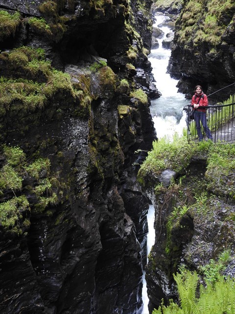
Lady Pinguin på Bordalsgjelet
Hvordan Bordalsgjelet ble dannet
Kløften selv består av fylitt, som er en av de mykere bergarter. Den inneholder mange store og små, halv og hele jettegryter. I de omkringliggende fjellene over gorge er det vanskeligere bergarter som kvartsitt og granitt.
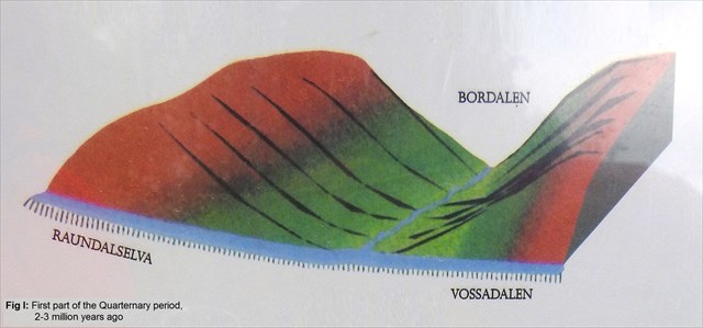
Før den siste istiden var situasjonen som vist i Fig I.
Elvene hadde gradvis gravd ut en dal med milde bakker.
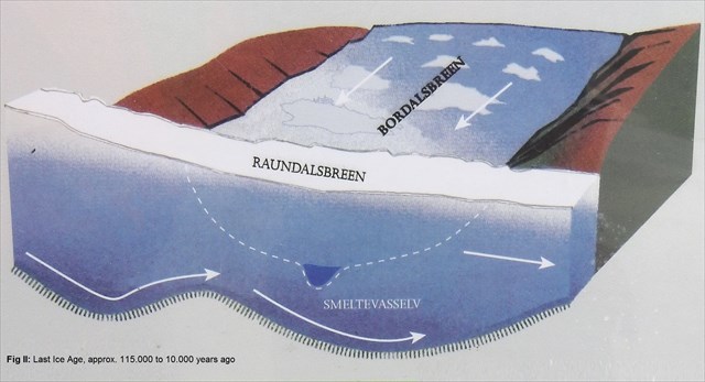
Kløften ble hovedsakelig dannet i den siste istiden, som varede fra ca 115.000 til 10.000 år siden. (se Fig. II)
Elva under isbreen skyllet store mengder glaciofluvialmateriale, som inneholdt hardrock og steinblokker, som raskt falt ned i den mykere steinen og hugget ut slugten. På det smaleste punktet er kløftenes bredde kun 1 meter bred, mens de bratte fjellsidene er over 50 meter høye.
I den nedre enden av canyon er det funnet to iskalkumulasjoner. I vest når en vifte som består av glaciofluvialmateriale 160 meter over havet. Dette antas å representere en subglacial opphopning, og klumper av svært vanskelig til ble funnet i en grusgruve (F på kartet). Kanien kan ha blitt fylt med till under deler av Weichselian-isbreften.
Det andre innskuddet er et marint delta med høyeste nivå som markerer den øvre havgrensen i området, 97 meter over havet, da en fjord nådde helt til Voss.
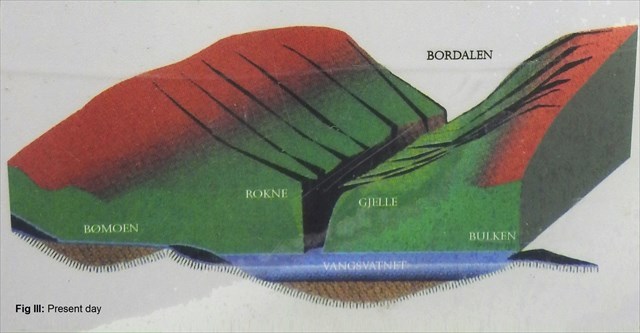
Bordalsgjelet canyon er en "justeringsdalen" som forbinder den tidligere dalgulvet i Bordalen-dalen til Vangsvatnet med en forskjell på 250 meter høyde. De nedre delene av denne 5 km lange canyonen er tilgjengelig for publikum langs en smal natursti i canyon.
Jettegrytene
Når du kommer til GZ, kan du se et godt antall jettegryter i og ved elven. Disse runde jettegryter danner langs eksponert berggrunn hvor en virvelstrøm virvler småstein og sandkorn i en sirkulær bane. Over tid har slipeffekten av disse slipemidlene boret sirkulære eller sylindriske hull inn i den underliggende berggrunden, og danner de store, glatt sidde hullene som ses her. Dette er en type fysisk forvitring kjent som korrosjon.
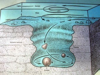
De spesifikke slipematerialene som skjærer hullene under dannelsen kalles grinders og finnes ofte i bunnen av jettegryter. Med den fortsatte nedadgående spiralvirkningen av kvernen blir jettegryter dypere og den en gang vinklede overflaten av kvernen glattes.
På cache
Hvis du kommer fra Voss og har litt tid, er det vel verdt å vandre 90 minutters returtur fra Voss til Bordalsgjelet. Det er også flere andre caches som finnes underveis.
Fra sentrum følger du grusveien langs Vangsvatnet mot Prestegardsmoen. Kryss broen over elven Vosso på slutten av Prestegardsmoen (merket som et trailhead waypoint), sving til høyre etter broen og følg Russarvegen langs elva. Veien er merket helt til Bordalsgjelet.
Hvis du ankommer med bil, kan du bruke de medfølgende parkeringskoordinatene.
For å logge denne Earthcache som en funnet, send svarene dine på spørsmålene nedenfor via e-post eller Message Center direkte til meg, og ikke legg dem inn i loggen din. Når du har sendt svarene dine, kan du logge deg på nettet online. Du trenger ikke å vente på svar, hvis det er problemer med svarene dine, vil jeg kontakte deg.
Spørsmål 1: Ved cachekoordinatene kan du se mange jettegryter i og ved elven. Beskriv størrelsen, formen og antall jettegryter som du observerer. Basert på dine observasjoner, hvordan tror du at disse jettegryter ble dannet?
Spørsmål 2: Beskriv i dine egne ord hvilke bevis som er tilstede her for å støtte ideen om at kløften du står i, ble dannet relativt rask.
Legg også til et bilde av deg selv, en personlig gjenstand og/eller GPS-en din på Bordalsgjelet i loggen din. Dette er en del av loggkravene og er ikke valgfritt.
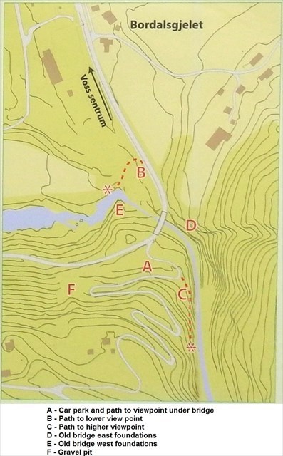
Vær oppmerksom på at i vintertid kan sti C som fører til Earthcaches koordinater, lukkes. Jettegryter som nevnt i spørsmål 1 kan også ses, men ikke som spektakulære, fra det andre synspunktet på østsiden av broen, overfor parkeringsplassen.
Sti B fører til enda et synspunkt med flott utsikt oppover dalen, og er også vel verdt et besøk.
Vennligst hold deg til de merkede stiene og ikke forsøk å klatre over gjerdet for din egen sikkerhet!

English
Bordalsgjelet is a spectacular natural attraction within walking distance from Voss town center, with impressive views of a variety of potholes formed in the riverbed over a period of many thousands of years.
Lady Pinguin at Bordalsgjelet
Please keep to the marked trails and do not attempt to climb over the fence for your own safety!
How the Bordalsgjelet was formed
The gorge itself is composed of phyllite, which is one of the softer kinds of rock. It contains many large and small, half and whole potholes. In the surrounding mountains above the gorge there are harder kinds of rock such as quartzite and granite.
Before the last Ice Age the situation was as shown in Fig I.
Rivers had gradually dug out a valley with gentle slopes.
The gorge was mainly formed during the last Ice Age, which lasted from approximately 115.000 to 10.000 years ago. (see Fig. II)
The river under the glacier washed down large quantities of glaciofluvial material, containing hard rock and boulders, which ground down into the softer rock quickly, carving out the gorge. At the narrowest point the width of the gorge is only 1 meter wide, while the steep mountain sides are over 50 meter high.
At the lower end of the canyon two glacial accumulations are found. To the west a fan composed of glaciofluvial material reaches 160 meter above sea level. This is thought to represent a subglacial accumulation, and lumps of very hard till were found in a gravel pit (F on the map). The canyon may have been filled with till during parts of the Weichselian glaciation.
The other deposit is a marine delta with the highest level marking the upper marine limit in the area, 97 meter above sea level, when a fjord reached all the way to Voss.
Bordalsgjelet canyon is a “valley of adjustment” connecting the former valley floor in Bordalen valley to Lake Vangsvatnet with a difference in elevation of 250 meter. The lower parts of this 5 km long canyon is accessible to the public along a narrow nature trail into the canyon.
Potholes
When you arrive at GZ you can see a fair number of potholes in and next to the riverbed. These round potholes form along exposed bedrock where an eddy current swirls pebbles and grains of sand in a circular path. Over time, the grinding action of these abrasive materials drilled circular or cylindrical holes into the underlying bedrock, forming the large, smooth-sided potholes seen here. This is a type of physical weathering known as corrasion.
The specific abrading materials which carve the potholes during their formation are called grinders and are frequently found in the bottom of the pothole. With the continued downward spiraling action of the grinder, the pothole becomes deeper and the once angular surface of the grinder is smoothed.
The cache
If you come from Voss and have some time, it is well worth to hike the 90 minutes return trip from Voss to Bordalsgjelet. There are also several other caches to be found along the way.
From the town center you follow the gravel path alongside Vangsvatnet lake towards Prestegardsmoen. Cross the bridge over the river Vosso at the end of Prestegardsmoen (marked as a trailhead waypoint), turn right after the bridge and follow Russarvegen road along the river. The road is marked all the way to Bordalsgjelet.
If you arrive by car you can use the provided parking coordinates.
To log this Earthcache as a found, please send your answers to the questions below to me by email or Message Center and do not post them in your log. Once you've sent your answers, you may log your find online. You don't have to wait for a reply, if there are any issues regarding your answers I will contact you.
Question 1: At the cache coordinates you can see many potholes in and next to the riverbed. Describe the size, shape and number of potholes that you observe. Based on your observations, how do you think these potholes were formed?
Question 2: Describe in your own words what evidence is present here to support the idea that the gorge you are standing in was formed relatively quick.
Also add a photo of yourself, a personal item and/or your GPS at Bordalsgjelet to your log. This is part of the log requirements and is not optional.
Please note that during winter times path C leading to the coordinates of the Earthcache can be closed. Potholes as mentioned in question 1 can also be seen, although not as spectaculair, from the other viewpoint on the east side of the bridge, across from the parking.
Path B leads to yet another viewpoint with a great view up the valley and is also well worth a visit.
Please keep to the marked trails and do not attempt to climb over the fence for your own safety!