EarthCaches are there for us to learn and see, but many of them are off the beaten track, where not all can get to, this is an attempt to try and meet the need of others who are not as able as others.
This EarthCache takes you to Bloomsbury Gardens..
So what do the co-ordinates take you to? Well look down at the paving slabs. Oh, I hear you sighing, but many may not be able to physically get up to where this stone comes from, and remember caching is there for all of us. No doubt you will have already walked through London, where the majority of the pavements are now man made, either concrete or some other form, but what you have here are original paving stones. These are known as Haslingden Flags. Haslingden is up the Irwell valley in Rossendale, Lancashire which used to be the centre for quarrying of this type of rock, indeed did you know that you are walking on the same material that they have in Trafalgar Square? So lets get down to the geology.
What is Haslingden Flag?
Flagstone is a type of sedimentary rock, relatively easy to split or quarry in slabs, and hence ideal for paving. It is also used for making fences and roofing. There are Upper and Lower Haslingden Flagstones and the name is given to layers of the stone that appear throughout the area (not only in Haslingden) although the most spectacular examples are in the Rossendale valley. It was quarried and mined in Rossendale.
When was it laid down?
The rocks that lie underneath the valleys and hills of Rossendale were formed millions of years ago at a time when the whole of what is now the North of England was covered by huge river deltas and lagoons. Sediments, mainly sands, silts and muds, were eroded from hills in an area that now includes Scandinavia and Greenland and were swept into vast river deltas and lagoons in a central basin in a position now occupied by the Pennines. The sediment settled to the bottom as the water slowed down in the deltas and lagoons. The nearest equivalent sediments of today are forming in huge river deltas such as the Mississippi delta. This sediment built up until it was hundreds of metres thick and was gradually compacted and cemented into the “sedimentary” rocks we know today. To geologists they form part of the Millstone Grit series. The overall thickness of sediments indicate infilling of a tremendous basin, yet features in the rocks, such as ripples like those on a beach, show shallow water conditions, so sediment infill must have kept pace with large-scale subsidence.
Whilst the general process that gave rise to sedimentary rocks was the same over the whole of the Pennines, conditions would vary from place to place giving rise to local variations in the type and sequence of rocks. Peculiar conditions in what was to become Rossendale gave rise to deep beds of hard sandstones, known geologically as Haslingden Flag. This stone has a hardness and silica content equivalent to granite and was the principal reason for the growth of quarrying in Rossendale. Haslingden Flag is of particular interest to geologists. Detailed geological mapping shows the shapes of the Millstone Grit deltas. The two most common types are found throughout the Pennines, but a third type is recognised only in the Haslingden Flags in Rossendale. This is an elongate delta: the nearest modern equivalent is the Mississippi / Everglades ‘Birds Foot’ type delta.
Why is this area special?
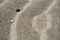
Now, I want you to look at each of the paving slabs, some of them are smooth, some are not, one has ripple marks Not like raspberry ripple ice cream, but like you find on a beach. When you have found this paving slab (it is a bit cracked), you are standing near or on an ancient marine bedform. Wow, marks from the Carboniferous area  .
.
Ripple Marks
Ripple marks are sedimentary structures, and indicate agitation by water (current or waves) or wind. This being geology there are different types of ripples.
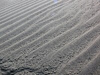 Straight ripples generate cross-laminae that all dip in the same direction, and lay in the same plane. These forms of ripples are constructed by unidirectional flow of the current.
 Sinuous ripples generate cross-laminae that are curvy. They show a pattern of curving up and down as shown in picture. Sinuous ripples produce trough cross lamination. All laminae formed under this type of ripple dip at an angle to the flow as well as downstream. These are also formed by unidirectional flow of current.
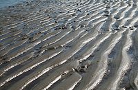 Catenary ripples generate cross-laminae that are curvy but have a unidirectional swoop. They show a pattern similar to what a repeated "W" would look like. Like the sinuous ripples, this form of ripple is created by unidirectional flow with the dip at an angle to the flow as well as downstream.
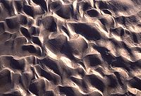 Linguoid ripples have lee slope surfaces that are curved generating a laminae similar to caternary and sinuous ripples. Linguoid ripples generate an angle to the flow as well as downstream. Linguoid ripples have a random shape rather than a "W" shape, as described in the catenary description.
This being an earthcache, in order to log it, I ask that you answer some questions. Please send them to me, and do not include them in your log. You can send them to me by using the message facility or email, both of which can be found by looking at my profile.
1. Generally what colour is the Haslingden flag?
2. Find the ripple marked stone, what type are the ripples?
3. Look around the area of the earthcache, can you see any other type of ripple formation, if so what type?
4. Why was Haslingden flag used here?