
Au point zéro de cette earthcache se trouve la source de l'Orne, une rivière naissante en ce lieu qui a donné le nom dans le département dans lequel nous nous trouvons.
"En 1790, année de création de 83 nouveaux départements, ce cours d'eau a donné son nom au département de l'Orne. On aurait pu l'appeler tout aussi bien la Sarthe qui prend naissance à Saint-Aquilin-de-Corbion près de Moulins-la-Marche ou la Mayenne dont la source est à La Lacelle, mais en nombre de kilomètres dans le département, il n'y a pas photo : l'Orne domine. Et puis c'est tout de même mieux de porter le nom d'un fleuve plutôt que celui d'une simple rivière !"
Le département de l’Orne compte environ 4000 km de fleuves et de rivières.
Ce fleuve est le deuxième plus important des cours d'eau normands, après la Seine, par sa longueur de 169,6 kilomètres et son débit 27,5 m3/s. Son dénivelé moyen est de 0,11%.
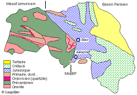
Le département de l'Orne comprend deux parties :
1) à l'Ouest : la partie armoricaine constituée de schistes précambriens, de granite et de grès primaires, parcourue par les plis hercyniens Est-Ouest.
2) à l'Est : le Bassin Parisien, constitué de couches quasi horizontales du Secondaire (Calcaire de la plaine Alençon-Sées et plus à l'Est, le Pays d'Auge et les sables du Perche).
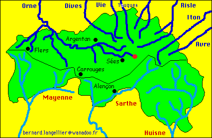
Dans sa course vers la Manche, l'Orne se charge de nombreux affluents, davantage sur sa rive gauche du fait de la présence du massif armoricain que sur sa rive droite. Il est ainsi rejoint tout au long de son parcours par la Sennevière, la Thouanne, la Cance, l'Udon, la Maire, la Rouvre, le Noireau, la Guigne, l'Odon, le Don, l'Ure, le Houay, la Baize et la Laize.
Né à Aunou-sur-Orne, à l’est de Sées, l’Orne serpente dans la plaine d'Argentan en direction du nord-ouest, puis, après avoir arrosé la cité épiscopale (Sées), Argentan et Écouché, l'Orne coule dans une vallée sinueuse et escarpée dans les granites d'Athis et les schistes et grès de la Suisse normande formant ainsi des gorges pittoresques.
De Putanges à la forêt de Grimbosq, l'Orne parcourt sa trouée héroïque dans un environnement de buttes élevées et sauvages (mont d'Ancre, mont Cerisy), traçant un sillon profond encadré de parois rocheuses impressionnantes (rochers des Parcs, rochers de la Houlle, Pain de Sucre) près de Clécy. Juste en aval de Putanges, à l'entrée des gorges, le barrage de Rabodanges a été édifié, en 1960, pour régulariser le débit du fleuve et produire de l'électricité (puissance de 6 500 kW), créant un lac artificiel d'une longueur de 7 km.
Dans la dernière partie de son cours, après avoir franchi, près de Thury-Harcourt, la boucle du Hom et ses schistes, témoins de la chaîne cadomienne vieille de 650 à 540 millions d'années, l'Orne contourne le Cinglais, traverse la plaine de Caen avant de rejoindre la Manche au Nord de Caen, à Ouistreham, dans le département du Calvados.
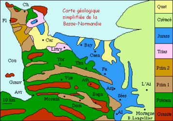
carte géologique simplifiée de la Basse Normandie
|
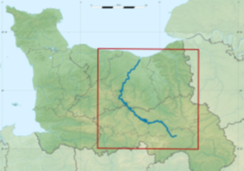
Le tracé de l'Orne en Basse Normandie
|
Le département subit également la ligne de partage des eaux Manche / Atlantique : au nord du département les cours d’eau se dirige vers la Manche, alors qu’au sud, ils s’écoulent vers la Loire puis l’Atlantique.
Définition : "Ligne de partage des eaux" :
(cf GC1JNRP)
Le bassin versant d'une rivière est l'ensemble des terrains tels que l'eau de pluie qu'ils reçoivent se retrouve par ruissellement et infiltration, plus ou moins directement, mais inéluctablement, dans cette rivière. Les bassins versants sont séparés l'un de l'autre par une ligne imaginaire qui correspond souvent à une crête de collines ou de montagnes, et qu'on peut comparer au faîte d'un toit, les gouttières représentant les rivières. Cette ligne s'appelle "ligne de partage des eaux". Le bassin versant d'un fleuve est constitué de l'addition des bassins de tous ses affluents en plus du sien propre avant son premier confluent.

Le partage des eaux

Photo de la Source de l'Orne, Juillet 2017
|
Pour loguer cette cache :
Pour valider votre visite sur le site, envoyez-moi vos réponses par mail ou centre de messagerie aux questions suivantes. Vous pouvez loguer "Found it" sans attendre mon accord, je vous contacterai si nécessaire.
Q0. Optionnel, une photo originale de vous ou de votre GPS sur les lieux ou au Mont Granier ou avec le Mont Granier sera fortement appréciée.
Q1. A la source de l'Orne, cloué à un arbre, quelle est l'altitude indiquée ? (ne cherchez pas cette réponse sur internet, les altitudes diffèrent). Si le panneau est toujours dans l'eau, donnez le nombre de kilomètres indiqués sur un autre panneau jusqu'à son embouchure.
Q2. Sur le panneau d'information, une autre commune est citée comme source probable de l'Orne.
2a) Quel est le nom de cette commune ?
2b) Citez la phrase qui explique pourquoi ce n'est pas le cas.
Q3. Sur le panneau d'information, on apprend qu'au XIXème siècle un projet de liaison entre Manche et Atlantique par voies navigables était envisagé.
3a) Citez les noms des trois rivières impliquées dans ce projet ?
3b) Pour quelle raison ce projet n'aboutit-il pas ?
Q4. En observant les cartes fournies dans le descriptif, à quelle échelle géologique appartient le sol où coule principalement l'Orne (source et embouchure) ?
|
At GZ of this earthcache is the source of the Orne , a nascent river in this place that gave the name in the department in which we find ourselves.
"In 1790, the year of creation of 83 new departments, this river gave its name to the department of Orne. It could also be called the Sarthe which originates at Saint-Aquilin-de-Corbion near Moulins-la-Marche or the Mayenne whose source is at La Lacelle, but in number of kilometers in the department, no matter : the Orne dominates. And it is better still to bear the name of a river rather than that of a simple river!"
The Orne department has about 4000 km of rivers and streams.
This river is the second largest river in Normandy, after the Seine river, with a length of 169.6 kilometers and a flow of 27.5 m3/s. Its average difference is 0.11%.
The department of Orne has two parts:
1) in the West: the Armorican part consisting of Precambrian schists, granite and primary sandstones, traversed by the East-West Hercynian folds.
2) in the East: the Paris Basin, made up of quasi horizontal layers of the Secondary (Limestone of the plain Alençon-Sées and more to the East, Pays d'Auge and the sands of the Perche).
In its course towards the Channel, the Orne is responsible for numerous tributaries, more on its left bank due to the presence of the Armorican massif than on its right bank. It is thus joined all along its route by the Sennevière, Thouanne, Cance, Udon, Mayor, Rouvre, Noireau, Guigne, Odon, Don, Ure, Houay, The Baize and the Laize.
Born in Aunou-sur-Orne, east of Sées, the Orne winds its way in the plain of Argentan towards the north-west, then, having watered the episcopal city (Sées), Argentan and Écouché, The Orne flows in a sinuous and steep valley in the granites of Athis and the shales and sandstones of the Swiss Normandy, forming picturesque gorges.
From Putanges to the forest of Grimbosq, the Orne traverses its heroic gap in an environment of high and wild mounds (Mount d'Ancre, Mount Cerisy), tracing a deep furrow framed by impressive rock walls (Parks rocks, Houlle, Sugar Loaf) near Clécy. Just downstream of Putanges, at the entrance to the gorges, the Rabodanges dam was built in 1960 to regulate the flow of the river and produce electricity (power of 6,500 kW), creating an artificial lake, A length of 7 km.
In the last part of his course, after crossing the loop of the Hom and its schists near Thury-Harcourt, witnesses of the Cadomian chain, which dates from 650 to 540 million years ago, the Orne bypasses the Cinglais, traverses the Plain of Caen before joining the Channel in the North of Caen, in Ouistreham, in the department of Calvados.
Geological map of Lower Normandy
|
The route of the Orne in Lower Normandy
|
The department also undergoes the watershed Manche / Atlantic: in the north of the department the rivers are directed towards the Channel, whereas in the south, they flow to the Loire then the Atlantic.
Definition: "Water dividing line" :
(cf GC1JNRP)
The watershed of a river is the whole of the land as the rainwater that it receives is found by runoff and infiltration, more or less directly, but inescapably, in this river. The watersheds are separated from one another by an imaginary line, which often corresponds to a crest of hills or mountains, and which can be compared to the ridge of a roof, the gutters representing the rivers. This line is called "watershed". The watershed of a river consists of the addition of the basins of all its tributaries in addition to its own before its first confluence.
Water dividing Line
Source of the Orne, July 2017
|
to log this cache :
To validate your visit on the site, you have to relay top the following questions and send me your answers by mail or message center. You can log your found it without waiting my permission, I will contact you if there is a problem.
Q0. Optional, an originaly photo of you or your GPS at GZ will be highly appreciated.
Q1. At the source of the Orne, nailed to a tree, what is the indicated altitude? (Do not look for this answer on the net, the altitudes differ). If the sign is still in the water, give the number of kilometers indicated on another sign to its mouth.
Q2. On the information panel, another municipality is cited as the probable source of the Orne.
2a) What is the name of this city ?
2b) Give the sentence that explains why this is not the case.
Q3. On the information panel, it is learned that in the 19th century a project of liaison between the Channel and the Atlantic by inland waterways was envisaged.
3a) Give the name of the three rivers implicated in this project.
3b) what is the reason the project didn't successfully ended ?
Q4. By observing the maps provided in the description, at what geological scale is the soil where the Orne flows (source and mouth)?
|