 Version en FRANCAIS
Le Plomb du Cantal, est le point culminant des monts du Cantal. Ses 1855 mètres d'altitude en font le deuxième plus haut sommet du Massif central, après le Puy de Sancy (1886 m).
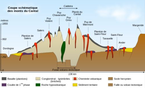
Avec ses voisins le Puy Griou, le Puy de Peyre-Arse, le Puy Mary ou encore le Puy Violent, il fait partie intégrante du stratovolcan du Cantal, le plus grand d'Europe, avec 60 km de diamètre et dont la hauteur, il y a 4 Ma, dépassait les 3 000 mètres.
Le stratovolcan du Cantal s'est édifié par étapes, pour l'essentiel entre 13 et 2 millions d’années. Ces différentes phases de construction et de destruction de l’édifice volcanique sont déterminées par les géologues grâce à l’observation de plusieurs couches de roches magmatiques distinctes. Cette édification de la montagne en strates identifiables est à l’origine de l’appellation « stratovolcan » pour désigner les Monts du Cantal.
On distingue plusieurs grandes périodes dans l’activité volcanique :
- Les premières éruptions basaltiques (13 à 7 Ma).
- L’édification du stratovolcan (10 à 6,5 Ma).
- L’effondrement du stratovolcan (autour de 7 Ma).
- Des intrusions phonolitiques (entre 7 et 6,5 Ma).
- Les basaltes supracantaliens (entre 7 et 2 Ma).
- L'érosion glaciaire et post-glaciaire de l'édifice volcanique (entre 120 000 et 10 000 ans)
Nous allons nous intérésser à la plus récente : L'érosion glaciaire et post-glaciaire.
A la fin de la dernière phase basaltique, les glaciers ont remodelé l'édifice volcanique en façonnant un réseau hydrographique dont la forme radiale actuelle naît au cœur de l'édifice.
Cette érosion a été particulièrement active au cours des épisodes glaciaires du Quaternaire, lorsque le centre du volcan du Cantal était largement recouvert par une épaisse calotte glaciaire.
Ces glaciers ont été de très grande importance. Epais de plusieurs centaines de mètres, ils s’allongeaient sur des dizaines de kilomètres et descendaient parfois très bas dans les vallées.
 |
Le phénomène d'inversion de relief
Il y a plus de 5 millions d'années, les coulées de basalte qui se sont épanchées des flancs du stratovolcan occupaient le fond des vallées (Plomb du Cantal). L'érosion (eaux de ruissellement, glacier...) ayant dégagé tous les matériaux "meubles", le basalte, beaucoup plus dur, s'est retrouvé en relief, formant une plateforme, les ruisseaux creusant de part et d'autre de nouvelles vallées. |
Le Plomb du Cantal lui-même, formé d'un culot de basanite (roche proche du basalte) vestige d'un lac de lave basaltique solidifiée, est la partie la plus récente de ce vaste édifice : il s'est formé il y a 2,9 Ma.
Celui-ci surmonte un amoncellement de plusieurs dizaines de coulées de trachyandésite et de brèches pyroclastiques (formées à la suite de nuées ardentes). Au Quaternaire récent, le Plomb du Cantal subit l'érosion glaciaire sans trop de dégâts puisqu'il y a 2,9 Ma il n'excédait pas 1 900 mètres.
(Source : http://www.laveissiere.fr/volcanisme-et-geologie-du-cantal_fr.html)
Voici les questions dont les réponses sont dans le texte ou aux tables d'orientation :
1. Durant quelle "grande période de l'activité volcanique" (parmi les 6 décrites précédement) s'est formée le Plomb du Cantal ?
2. De quelle table d'orientation est visible le Puy Mary ?
3. Citez le nom de la roche que vous avez sous les pieds.
4. (Non obligatoire mais appréciée) Votre photo au sommet du plomb du Cantal.
Loguez cette cache "Found it" et envoyez-moi vos propositions de réponses, soit via mon profil, soit via la messagerie geocaching.com (Message Center), et je vous contacterai en cas de problème..
 ENGLISH Version
Le Plomb du Cantal, is the highest point of the Cantal mountains. Its 1855 meters of altitude, make it the second highest summit of the Massif central, after le Puy de Sancy (1886 m).
With its neighbors Le Puy Griou, Le Puy de Peyre-Arse, Le Puy Mary and Le Puy Violent, it is an integral part of the stratovolcano of Cantal, the largest in Europe, with a diameter of 60 kms and whose height there are 4 My exceeded the 3,000 meters.
The stratovolcano of Cantal was built in stages, mostly between 13 and 2 million years ago. These different phases of construction and destruction of the volcanic edifice are determined by geologists through the observation of several layers of distinct magmatic rocks. This edification of the mountain in identifiable strata is at the origin of the name 'stratovolcan' to designate the Monts du Cantal.
There are several major periods in volcanic activity:
- The first basaltic eruptions (13 to 7 My).
- The construction of the stratovolcano (10 to 6.5 My)
- The collapse of the stratovolcano (around 7 My).
- Phonolite intrusions (between 7 and 6.5 My).
- The supracantalian basalts (between 7 and 2 My).
- The glacial and post-glacial erosion of the volcanic edifice (between 120,000 and 10,000 years).
We will be interested in the most recent: Glacial and post-glacial erosion.
At the end of the last basaltic phase, the glaciers reshaped the volcanic edifice by shaping a hydrographic network whose current radial form is born in the heart of the building.
This erosion was particularly active during the glacial episodes of the Quaternary, when the center of the Cantal volcano was largely covered by a thick ice cap.
These glaciers were of great importance. Thousands of meters thick, they stretched for tens of kilometers and sometimes descended very low into the valleys.
|
The phenomenon of inversion of relief
More than 5 million years ago, basalt flows poured out from the sides of the stratovolcano and occupied the bottom of the valleys (Plomb du Cantal). Since erosion (runoff, glacier ...) has evolved from all 'soft' materials, the basalt, which is much harder, has become raised, forming a platform, the streams New valleys. |
Le Plomb du Cantal itself, formed of a basanite pellet (rock near the basalt), remains the most recent part of this vast building: it was formed there 2.9 My.
The latter surmounts an accumulation of several dozen streams of trachyandesites and pyroclastic breccias (formed after fiery clouds). In the recent Quaternary, the Lead of the Cantal undergoes glacial erosion without too much damage since it is 2.9 My it did not exceed 1,900 meters.
(Source : http://www.laveissiere.fr/volcanisme-et-geologie-du-cantal_fr.html)
Here are the questions whose answers are in the text or at the orientation tables:
1. During what 'great period of volcanic activity' (among the 6 described above) was Le Plomb du Cantal formed?
2. From which orientation table is Le Puy Mary?
3. Name the stone under your feet.
4. (Not obligatory but appreciated) Your picture at the top of Le Plomb du Cantal.
Log this cache 'Found it' and send me your answers either via my profile or via geocaching.com (Message Center) and I will contact you in case of problem.