Sur les "earthcaches", il n'y a ni boîte, ni logbook. Pour valider votre Earthcache il vous suffit de vous rendre sur place et de répondre aux questions posées. Vous pouvez loguer en "Found it" sans attendre mais vous devez me faire parvenir vos réponses en même temps en me contactant soit par mail dans mon profil, soit via la messagerie geocaching.com (Message Center), et je vous contacterai en cas de problème. Les logs enregistrés sans réponses seront supprimés.
On " Earthcaches ", es gibt keine Box, kein Logbook. Um Ihr Earthcache zu validieren müssen Sie nur rausgehen und die Fragen beantworten. Sie können "Found it" loguen ohne Warten , aber Sie müssen mir Ihre Antworten zur gleichen Zeit senden , Sie können mich kontaktieren entweder per E-Mail in meinem Profil oder über geocaching.com Messaging ( Message Center), und ich werde Ihnen bei Problemen kontaktieren. Log ohne antworten werden gelöscht.
On " Earthcaches " , there is no box , no logbook . To validate your Earthcache you just have to go out there and answer the questions . You can log "Found it" without waiting but you must send me your answers at the same time by contacting me either by email in my profile or via geocaching.com messaging (Message Center ), and I will contact you in case of problems. Registered logs without answered will be deleted.
Origine de la tourbière de Hanau (historique)
Ursprung des Torfmoores von Hanau ( Geschichte)
Origin of the peat bog of Hanau ( history)
Le cadre géologique : point de départ
Les tourbières des Vosges du nord sont situées dans une bande de terrain d'environ 15 km de long sur 7 km de large. Elle correspond à la zone d'affleurement du toit des Couches de Trifels, coiffée de lambeaux résiduels qui appartiennent à l'unité supérieure des Couches de Rehberg. Le Grès vosgien qui forme cette série est constitué essentiellement de bancs résultant du dépôt de sables fluviatiles au Trias. Toutefois, les Couches de Rehberg comportent également des grès peu indurés, ces derniers ont été interprétés comme étant des dépôts éoliens (Dachroth). Cette moindre résistance conjuguée aux effets de la tectonique tertiaire a favorisé son déblaiement lors des périodes froides.
Der geologische Rahmen: Ausgangspunkt
Die Torfmoore der nördlichen Vogesen sind in einem Streifen von etwa 15 km lang und 7 km breit gelegt. Es entspricht der Ausstreichen Zone von des Daches der Schichten von Trifels, tragende Restschichten , die zur höheren Einheit Rehberg Schichten gehören. Der Vogesen-Sandstein , der diese Serie bilden besteht im wesentlichen aus Bänke, die aus der Ablagerung von Flusssand in der Trias ergibt. Aber auch die Schichten von Rehberg enthalten wenig verhärtet Sandsteine die als äolische Hinterlegungen (Dachroth) interpretiert sind. Dieser niedrigere Widerstand kombinierten mit tertiären tektonischen Effekten erleichtert seine Entfernung während der kalten Jahreszeit.
The geologic frame: starting point
The peat bogs of Vosges of the North are situated in a band of ground about 15 km long on 7 km wide. It corresponds to the zone of outcrop of the roof of the Layers of Trifels, combed by residual scraps which belong to the superior unit of the Layers of Rehberg. The Stoneware from Vosge which forms this series is essentially constituted by benches resulting from the deposit of fluviatiles sands in the Trias. However, the Layers of Rehberg also contain little hardened stonewares, the latter were interpreted as being wind deposits (Dachroth). This slightest resistance conjugated to the effects of the tertiary tectonics favored its clearing during cold periods.
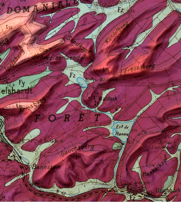
Le résultat visible sur l'extrait de carte ci-dessus est une géomorphologie marquée par des échines de grès résiduelles séparées par des vallées larges à fond plat. Les fonds de vallées sont comblés par des alluvions sableuses provenant du démantèlement des grès. Elles favorisent l'installation de sols hydromorphes (montrant des marques physiques d'une saturation régulière en eau ) colonisés par des formations de type tourbières. C'est le cas du cours du ruisseau de Waldeck qui se jette dans le Falkensteinbach.
Das sichtbare Ergebnis auf dem obigen Karte Bereich wird durch eine Geomorphologie Restsandsteinkragen durch weite Täler mit flachem Boden getrennt markiert. Die Talböden sind mit Sand Schwemmland aus demontierten Sandstein gefüllt. Sie fördern die Installation von schlammigen Böden (körperlichen Anzeichen einer regelmäßigen Vernässung zeigt) kolonisierten durch Moor artige Formationen. Dies ist der Fall natürlich der Waldeck Strom, der in das Falkensteinbach fließt.
The result visible on the map extract above is a geomorphology marked by residual sandstone spines separated by broad flat-bottomed valleys. The bottoms of the valleys are filled with sandy alluvium from the dismantling of the sandstones. They favor the installation of hydromorphic soils (showing physical marks of a regular saturation of water) colonized by formations of peat type. This is the case of the course of the Waldeck stream which flows into the Falkensteinbach.
Dans les Vosges du nord, malgré l'altitude relativement basse, les vallons et cuvettes forment des poches où le froid stagne (moyenne de température annuelle proche de 10°c). Les précipitations sont élevées (950 mm) et réparties sur l'année en raison de la double influence atlantique et continentale (orages d'été). Le grès se désagrège en sables très pauvres en éléments minéraux ce qui rend l'eau de ruissellement acide (PH voisin de 5). La végétation qui convient à ces milieux engorgés comporte des espèces à affinité boréale considérées comme relictuelles des périodes glaciaires et des espèces à affinité atlantique.
In den nördlichen Vogesen, trotz der relativ geringen Höhe, Täler und Becken bilden Taschen, in denen kalten stagnierenden (jährliche Durchschnittstemperatur von etwa 10 ° C). Niederschlag ist hoch (950 mm) und erstreckt sich über das Jahr wegen der doppelten Atlantik und kontinentalem Einfluss (Sommerstürme ). Der Sandstein zerfällt in sehr arm an Mineralien Sanden Herstellung Säure Ablaufwasser (pH-Wert nahe 5). Die Vegetation, die diese überlasteten Gebiete paßt umfasst boreale Affinität Spezies betrachtet relict Eiszeiten und Atlantic Affinität Arten.
In the northern Vosges, despite the relatively low altitude, the valleys and basins form pockets where the cold stagnates (average annual temperature close to 10 ° c). Precipitation is high (950 mm) and spread over the year due to the double Atlantic and continental influence (summer storms). The sandstone disintegrates into sand very poor in mineral elements which makes the water runoff acid (PH near 5). The vegetation suitable for these congested environments includes species with boreal affinity considered to be relictual of the glacial periods and species with Atlantic affinity.
Une tourbière c’est quoi ?
Was ist ein Torfmoor?
What is a bog?
La tourbière résulte d'un équilibre entre différents facteurs :
Das Torfmoor ergibt sich aus einem Gleichgewicht zwischen unterschiedlichen Faktoren :
The peat bog results from a balance between various factors :
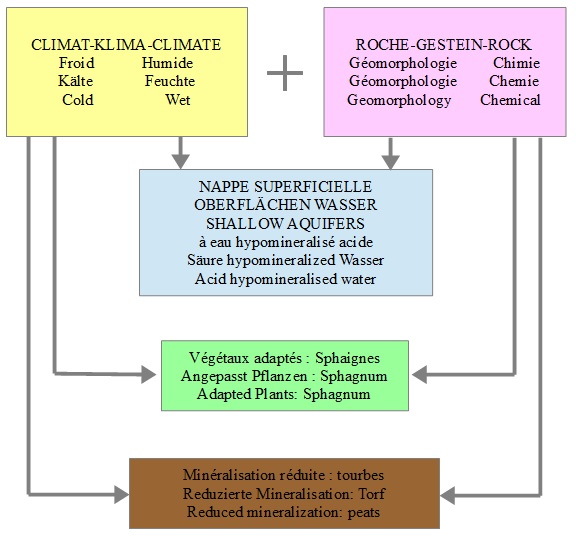
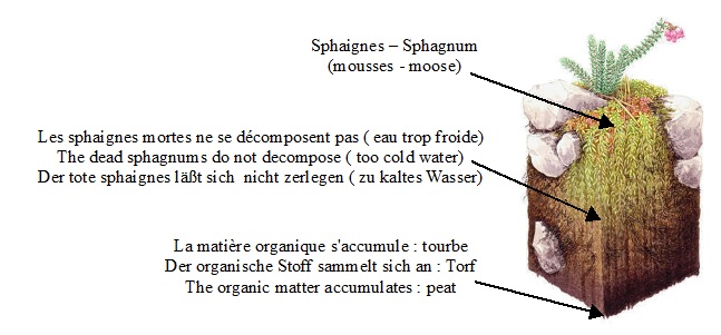
Une tourbière est le lieu où se forme de la tourbe. La tourbe est un sol composé de végétaux dont la décomposition est incomplète. Dans le cas d’une tourbière acide, les sphaignes (mousses absorbant de grandes quantités d’eau) sont les principales composantes de la tourbe.
Ein Torfmoor ist ein Ort wo sich Torf bildet. Der Torf ist ein Boden, der aus Pflanzen ohne komplette Verwesung besteht. Bei einem sauren Torfmoor, sind Spagrums (Moose, die eine Menge Wasser absorbieren) die Hauptkomponenten des Torfes.
A bog is a peat accumulating wetland that supports plant communities able to thiwe in waterlogged, acid, nutriment-poor conditions. The peat is a vegetal compound whose decag is not finished. An acid bog is one made of Sphagnum’s (mosses which can carry heavy water)
La Tourbière de l'étang de Hanau
Elle est située dans une cuvette qui recueille les eaux de pluie et des ruisseaux.
Le grès du sous-sol donne un sol sablonneux très pauvre.
Le climat y est continental, c’est à dire froid en hiver et sec en été.
Ces conditions particulières ont permis la formation de cette tourbière abritant des espèces animales et végétales rares.
Un sentier long d’un kilomètre jalonné de panneaux explicatifs a été aménagé au cœur de cette tourbière permettant de comprendre la lente évolution des tourbières et ses multiples intérêts.
Der Entdeckungspfad des hanauer Torfmoores
Er befindet sich in einem Kessel, der alle Regen-und Bachwässer auffängt.
Der hier vorkommende Sandstein bedingt einen nährstoffarmen Boden.
Es herrscht kontinentales Klima, d.h. kalt im Winter und trocken im Sommer.
Diese besonderen Eigenschaften haben die Bildung dieses Torfmoores zur Folge, in dem seltene Pflanzen und Tiere zu finden sind.
In seiner Mitte wurde ein Kilometer langer Lehrpfad mit Schildern eingerichtet, die erklären, wie sich diese Torfmoore langsam entwickelt haben und welch Interessante Dinge sie bieten.
The "peatery" of Hanau's pond
It is located in a basin which catchs the rain and river waters.
The underground's sand stone gives a poorish sandy ground.
Climate is continental, which means cold in winter and dry in summer.
These particular conditions permitted this peatery to develop itself.
It shelters rare vegetals and animals species .
A one kilometer long footpath is marked with noticeboards for explanations details, so that one can understand easily the slow evolution of the peateries and its numerous interests.
Une nature à préserver Une tourbière est un milieu naturel très fragile et, afin de conserver et protéger cet environnement précieux, merci de respecter ces quelques consignes :
- Rester sur le sentier balisé et les caillebotis
- Interdiction de cueillir des plantes
- Prière d’emporter vos déchets
- Les chiens sont interdits (même en laisse).
Eine Natur, die zu schützen ist Ein Torfmoor ist ein empfindliches Naturgebiet. Um die Umwelt zu pflegen und schützen, bitte beachten Sie folgende Regeln:
- Bleiben Sie auf dem ausgeschilderten Pfad und Lattenroste
- Das Pflücken der Pflanzen ist verboten
- Nehmen Sie die Abfälle mit
- Hunde sind verboten (auch an der Leine geführt).
A nature to be preserved A bog is a very fragile area, in order to protest it please follow these recommendations:
- Stay on the guided path
- Do not pick up the plants
- Don’t leave trash
- Dogs are forbidden (even with a doglead)
Pour valider cette Earthcache veuillez répondre aux questions suivantes:
Um diesen Earthcache zu validieren beantworten Sie bitte die folgenden Fragen:
To validate this Earthcache please answer the following questions:
- Quelles sont les conditions nécessaires à la formation de la tourbe ?
- Quel est le rythme de croissance de la tourbière?
- Grâce aux informations des panneaux et à vos observations, décrivez la plante à l'origine de la tourbe (nom, taille approximative de la partie en croissance, couleur …)
- Rendez-vous au ponton au bord du lac, observez et décrivez la terre au pied du premier poteau du ponton (couleur, texture...)
- Was sind die Voraussetzungen für die Bildung von Torf?
- Wie ist der Wachstumsrhythmus des Torfmoores?
- Beschreiben Sie anhand der Informationen auf den Tafeln und Ihrer Beobachtungen die Pflanze, die die Quelle des Torfes ist (Namen, ungefähre Größe des wachsenden Teils, Farbe ...)
- Gehen Sie auf der Schiffsbrüke am Seeufer, beobachten Sie und beschreiben Sie die Erde am Fuß des ersten Pfostens der Schiffsbrüke (Farbe, Textur...)
- What are the conditions necessary for the formation of the peat?
- What is the growth rate of the peat bog?
- Using the information on the panels and your observations, describe the plant that is at the origin of the peat (name, approximate size of the growing part, color ...)
- Go to the pontoon by the lake, observe and describe the ground at the foot of the first stake of the pontoon (color, texture …)